Bestand:Saint Helena Airport location.svg

Afmetingen van deze voorvertoning van het type PNG van dit SVG-bestand: 740 × 600 pixels Andere resoluties: 296 × 240 pixels | 592 × 480 pixels | 948 × 768 pixels | 1.264 × 1.024 pixels | 2.527 × 2.048 pixels | 802 × 650 pixels.
Oorspronkelijk bestand (SVG-bestand, nominaal 802 × 650 pixels, bestandsgrootte: 617 kB)
| Dit is een bestand van Wikimedia Commons. Onderstaande beschrijving komt van de beschrijving van het bestand daar. |
Beschrijving
| Beschrijving |
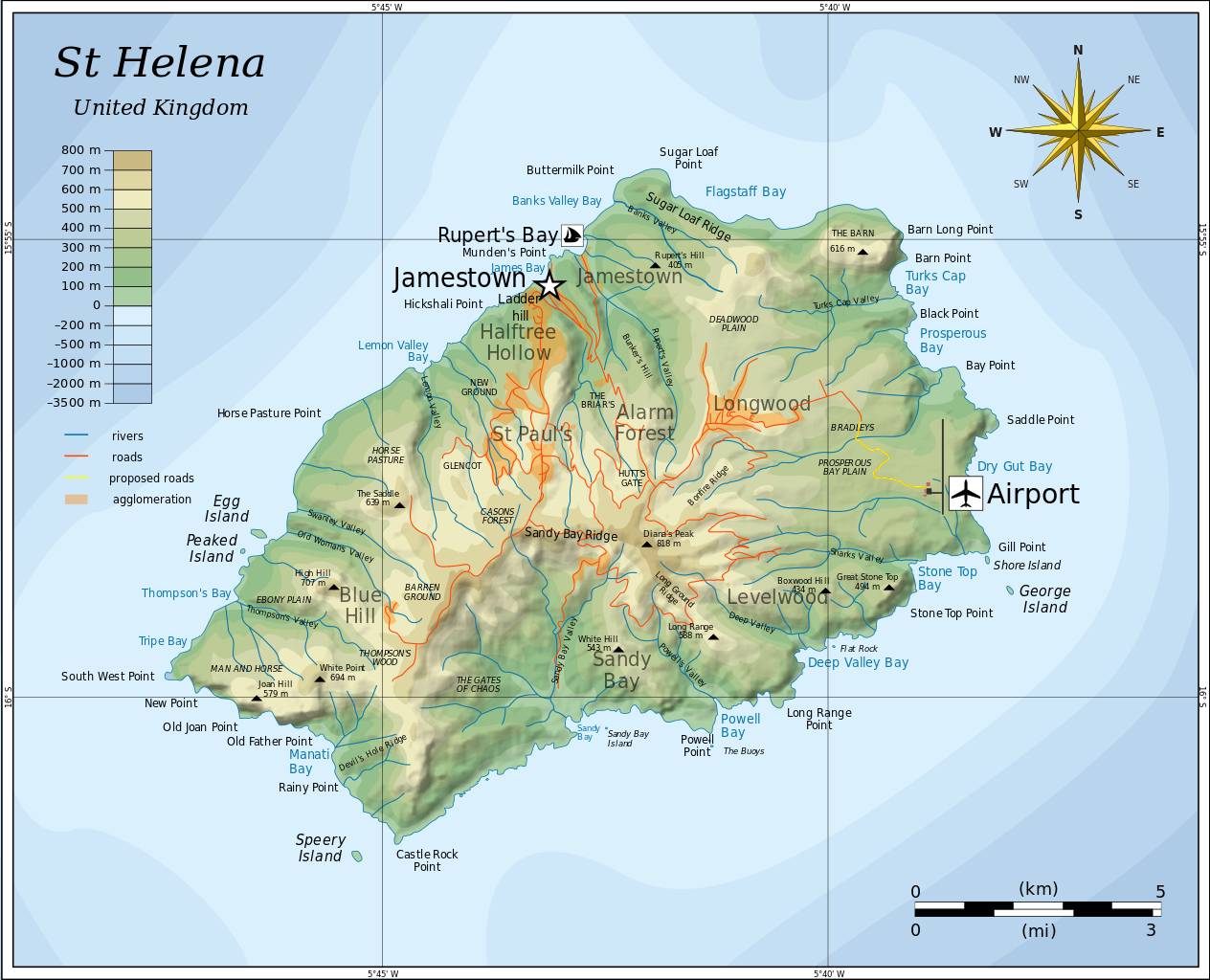
English: Topographic map of the British island of Saint Helena showing Airport. |
| Datum | |
| Bron |
Modified Mysid's topographic map (Topographic map of Saint Helena-en.svg) in Inkscape. Based on several sources:
|
| Auteur | cvdr |
| Andere versies |
Afgeleide werken van dit bestand: |
| SVG ontwikkeling |
Licentie
Ik, de auteursrechthebbende van dit werk, maak het hierbij onder de volgende licenties beschikbaar:
Dit bestand is gelicenseerd onder de Creative Commons-licentie Naamsvermelding-Gelijk delen 3.0 Unported
- De gebruiker mag:
- Delen – het werk kopiëren, verspreiden en doorgeven
- Remixen – afgeleide werken maken
- Onder de volgende voorwaarden:
- naamsvermelding – U moet op een gepaste manier aan naamsvermelding doen, een link naar de licentie geven, en aangeven of er wijzigingen in het werk zijn aangebracht. U mag dit op elke redelijke manier doen, maar niet zodanig dat de indruk wordt gewekt dat de licentiegever instemt met uw werk of uw gebruik van zijn werk.
- Gelijk delen – Als u het werk heeft geremixt, veranderd, of erop heeft voortgebouwd, moet u het gewijzigde materiaal verspreiden onder dezelfde licentie als het oorspronkelijke werk, of een daarmee compatibele licentie.

|
Toestemming wordt verleend voor het kopiëren, verspreiden en/of wijzigen van dit document onder de voorwaarden van de GNU-licentie voor vrije documentatie, versie 1.2 of enige latere versie als gepubliceerd door de Free Software Foundation; zonder Invariant Sections, zonder Front-Cover Texts, en zonder Back-Cover Texts. Een kopie van de licentie is opgenomen in de sectie GNU-licentie voor vrije documentatie. |
U mag zelf één van de licenties kiezen.
Beschrijving
Bestandsgeschiedenis
Klik op een datum/tijd om het bestand te zien zoals het destijds was.
| Datum/tijd | Miniatuur | Afmetingen | Gebruiker | Opmerking | |
|---|---|---|---|---|---|
| huidige versie | 25 dec 2011 21:34 | | 802 × 650 (617 kB) | Cvdr | == Summary == {{Information |Description={{en|1=Topographic map of the British island of Saint Helena.}} |Source=Modified in Inkscape. Based on several sources: * Mysid's Topographic map of Saint Helena-en.svg * [ht |
| 24 dec 2011 23:54 |  | 600 × 600 (5 kB) | Cvdr |
Bestandsgebruik
Dit bestand wordt op de volgende pagina gebruikt:
Globaal bestandsgebruik
De volgende andere wiki's gebruiken dit bestand:
- Gebruikt op cs.wikipedia.org
- Gebruikt op de.wikipedia.org
- Gebruikt op en.wikipedia.org
- Gebruikt op es.wikipedia.org
- Gebruikt op fi.wikipedia.org
- Gebruikt op fr.wikipedia.org
- Gebruikt op fy.wikipedia.org
- Gebruikt op it.wikipedia.org
- Gebruikt op ja.wikipedia.org
- Gebruikt op uk.wikipedia.org
- Gebruikt op zh.wikipedia.org