Bestand:Saint Empire après 1801.svg

Afmetingen van deze voorvertoning van het type PNG van dit SVG-bestand: 779 × 600 pixels Andere resoluties: 312 × 240 pixels | 623 × 480 pixels | 997 × 768 pixels | 1.280 × 986 pixels | 2.560 × 1.971 pixels | 1.344 × 1.035 pixels.
Oorspronkelijk bestand (SVG-bestand, nominaal 1.344 × 1.035 pixels, bestandsgrootte: 449 kB)
| Dit is een bestand van Wikimedia Commons. Onderstaande beschrijving komt van de beschrijving van het bestand daar. |
Beschrijving
| Beschrijving |
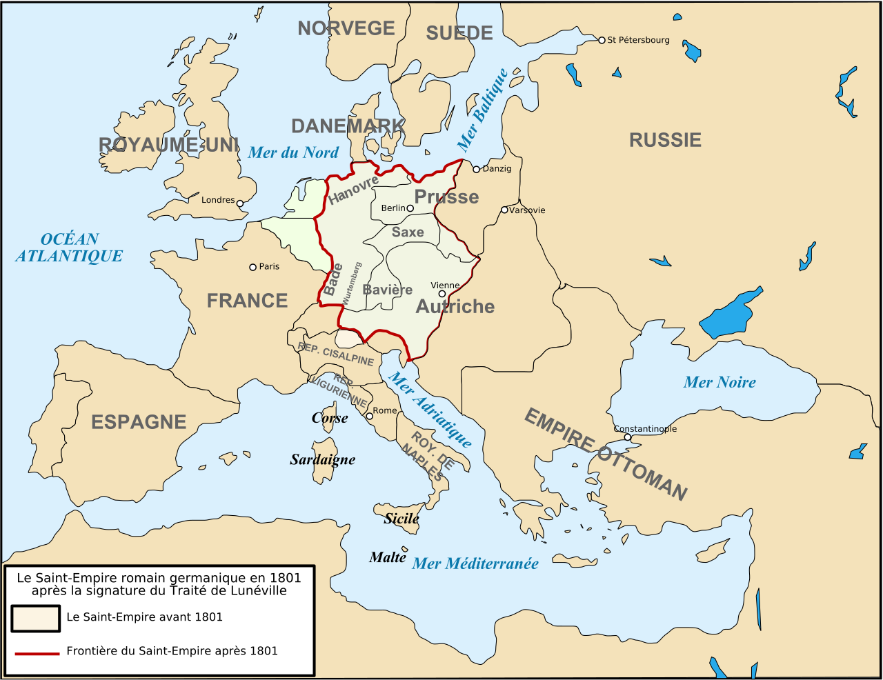
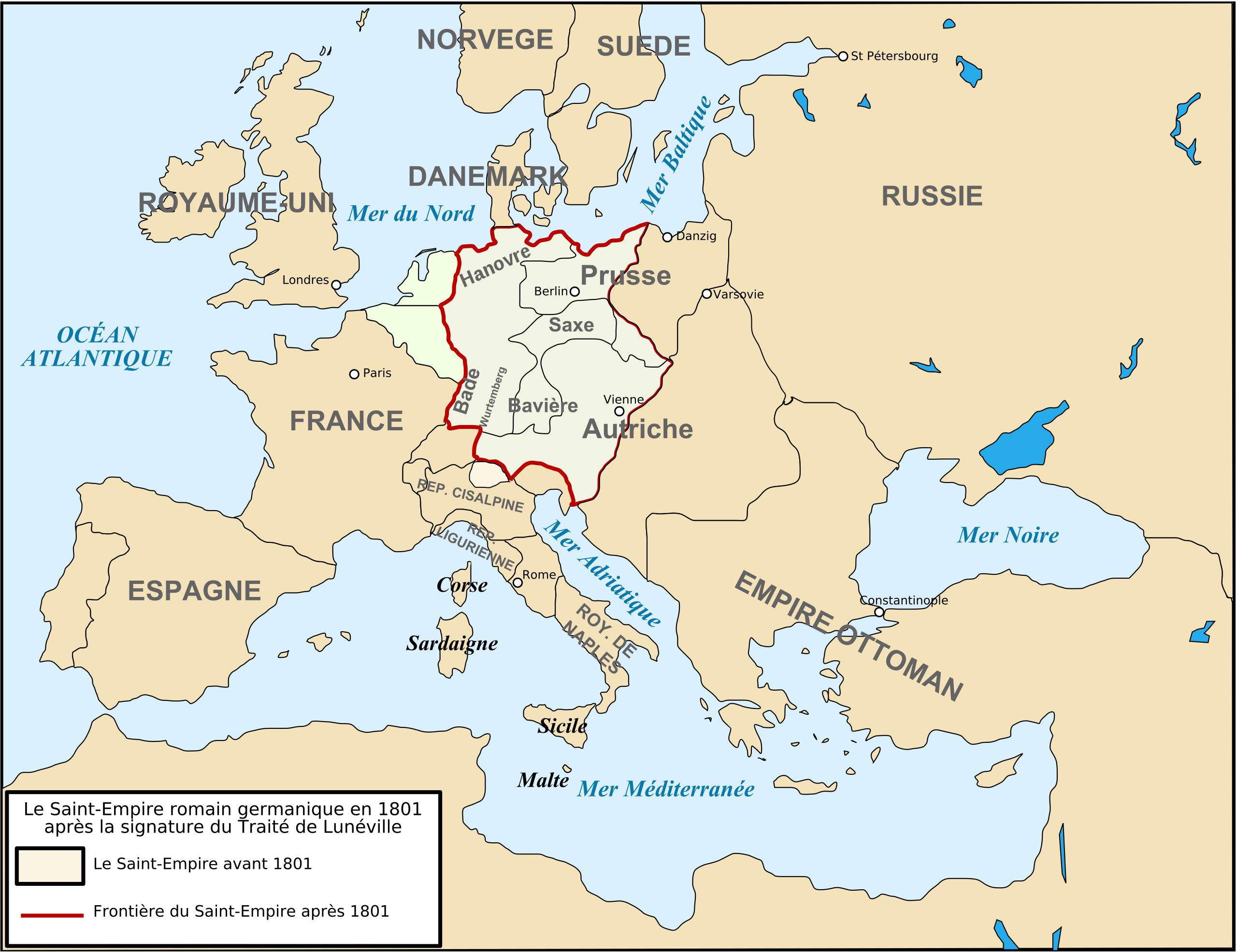
Français : Carte de l'Europe après le traité de Lunéville de 1801. |
| Datum | |
| Bron | Eigen werk |
| Auteur | Tinodela |
| Andere versies |
  |
Licentie
Ik, de auteursrechthebbende van dit werk, maak het hierbij onder de volgende licenties beschikbaar:

|
Toestemming wordt verleend voor het kopiëren, verspreiden en/of wijzigen van dit document onder de voorwaarden van de GNU-licentie voor vrije documentatie, versie 1.2 of enige latere versie als gepubliceerd door de Free Software Foundation; zonder Invariant Sections, zonder Front-Cover Texts, en zonder Back-Cover Texts. Een kopie van de licentie is opgenomen in de sectie GNU-licentie voor vrije documentatie. |
Dit bestand is gelicenseerd onder de Creative Commons-licenties Naamsvermelding-Gelijk delen 3.0 Unported, 2.5 Algemeen, 2.0 Algemeen en 1.0 Algemeen.
- De gebruiker mag:
- Delen – het werk kopiëren, verspreiden en doorgeven
- Remixen – afgeleide werken maken
- Onder de volgende voorwaarden:
- naamsvermelding – U moet op een gepaste manier aan naamsvermelding doen, een link naar de licentie geven, en aangeven of er wijzigingen in het werk zijn aangebracht. U mag dit op elke redelijke manier doen, maar niet zodanig dat de indruk wordt gewekt dat de licentiegever instemt met uw werk of uw gebruik van zijn werk.
- Gelijk delen – Als u het werk heeft geremixt, veranderd, of erop heeft voortgebouwd, moet u het gewijzigde materiaal verspreiden onder dezelfde licentie als het oorspronkelijke werk, of een daarmee compatibele licentie.
U mag zelf één van de licenties kiezen.
Bestandsgeschiedenis
Klik op een datum/tijd om het bestand te zien zoals het destijds was.
| Datum/tijd | Miniatuur | Afmetingen | Gebruiker | Opmerking | |
|---|---|---|---|---|---|
| huidige versie | 10 mei 2019 09:53 | | 1.344 × 1.035 (449 kB) | Isaac Sanolnacov | Orthographe : Hanovre ne prend qu'un en français |
| 23 aug 2008 15:04 |  | 1.260 × 970 (584 kB) | Tinodela | {{Information |Description= |Source= |Date= |Author= |Permission= |other_versions= }} | |
| 23 aug 2008 14:51 |  | 1.260 × 970 (584 kB) | Tinodela | {{Information |Description= |Source= |Date= |Author= |Permission= |other_versions= }} | |
| 23 aug 2008 14:50 |  | 1.260 × 970 (176 kB) | Tinodela | {{Information |Description={{fr|1=Carte de l'Europe après le traité de Lunéville de 1801.}} |Source=travail personnel (own work) |Author=Tinodela |Date=23/08/2008 |Permission= |other_versions=[[Image:Strategic Situation of Europe 1801 |
Bestandsgebruik
Dit bestand wordt op de volgende 2 pagina's gebruikt:
Globaal bestandsgebruik
De volgende andere wiki's gebruiken dit bestand:
- Gebruikt op an.wikipedia.org
- Gebruikt op ar.wikipedia.org
- Gebruikt op br.wikipedia.org
- Gebruikt op ca.wikipedia.org
- Gebruikt op cs.wikipedia.org
- Gebruikt op da.wikipedia.org
- Gebruikt op el.wikipedia.org
- Gebruikt op es.wikipedia.org
- Gebruikt op fr.wikipedia.org
- Gebruikt op id.wikipedia.org
- Gebruikt op it.wikipedia.org
- Gebruikt op ka.wikipedia.org
- Gebruikt op lmo.wikipedia.org
- Gebruikt op ms.wikipedia.org
- Gebruikt op pl.wikipedia.org
- Gebruikt op sv.wikipedia.org
- Gebruikt op tr.wikipedia.org
- Gebruikt op zh.wikipedia.org