Bestand:Rokycany District 2010 names RO CZ.png

Grootte van deze voorvertoning: 484 × 600 pixels. Andere resoluties: 194 × 240 pixels | 387 × 480 pixels | 702 × 870 pixels.
Oorspronkelijk bestand (702 × 870 pixels, bestandsgrootte: 101 kB, MIME-type: image/png)
| Dit is een bestand van Wikimedia Commons. Onderstaande beschrijving komt van de beschrijving van het bestand daar. |
| Beschrijving |
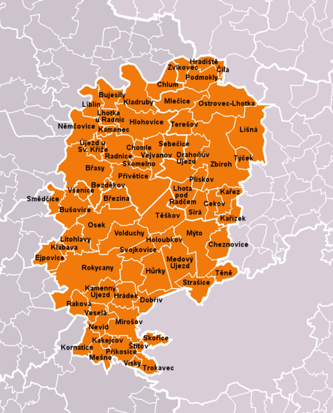
Čeština: Obce okresu Rokycany dle stavu k roku 2010 (68 obcí). Bílé linie o různé tloušťce představují hranice obcí, správních obvodů, okresů a krajů. S územím okresu je rozsahem totožný správní obvod obce s rozšířenou působností Rokycany.
English: Municipalities of Rokycany District as of 2010 (68 municipalities in total). White lines of variable thickness show boundaries of municipalities, administrative areas, districts and regions. The territory is identical with administrative area of Rokycany as a Municipality with Extended Competence. |
| Datum | |
| Bron | Self made, based on File:Rokycany District 2010 RO CZ.png |
| Auteur | User:Miaow Miaow |
| Toestemming (Hergebruik van dit bestand) |
PD-self |
| Andere versies |
|

Licentie
| Ik, de auteursrechthebbende van dit werk, geef dit werk vrij in het publieke domein. Dit is wereldwijd van toepassing. In sommige landen is dit wettelijk niet mogelijk; in die gevallen geldt: Ik sta iedereen toe dit werk voor eender welk doel te gebruiken, zonder enige voorwaarden, tenzij zulke voorwaarden door de wet worden voorgeschreven. |
Bestandsgeschiedenis
Klik op een datum/tijd om het bestand te zien zoals het destijds was.
| Datum/tijd | Miniatuur | Afmetingen | Gebruiker | Opmerking | |
|---|---|---|---|---|---|
| huidige versie | 14 mrt 2010 23:40 | | 702 × 870 (101 kB) | Miaow Miaow | {{Information |Description={{cs|'''Obce okresu Rokycany''' dle stavu k roku 2010 (68 obcí). Bílé linie o různé tloušťce představují hranice obcí, správních obvodů, okresů a krajů. S územím okresu je rozsahem totožn |
Bestandsgebruik
Dit bestand wordt op de volgende pagina gebruikt:
Globaal bestandsgebruik
De volgende andere wiki's gebruiken dit bestand:
- Gebruikt op azb.wikipedia.org
- Gebruikt op bg.wikipedia.org
- Gebruikt op cs.wikipedia.org
- Gebruikt op de.wikipedia.org
- Gebruikt op en.wikipedia.org
- Gebruikt op eo.wikipedia.org
- Gebruikt op fa.wikipedia.org
- Gebruikt op fr.wikipedia.org
- Gebruikt op hu.wikipedia.org
- Gebruikt op it.wikipedia.org
- Gebruikt op ko.wikipedia.org
- Gebruikt op ms.wikipedia.org
- Gebruikt op pl.wikipedia.org
- Gebruikt op pnb.wikipedia.org
- Gebruikt op pt.wikipedia.org
- Gebruikt op ru.wikipedia.org
- Gebruikt op sk.wikipedia.org
- Gebruikt op war.wikipedia.org
- Gebruikt op zh.wikipedia.org