Bestand:Randstad Population Bubbles (nl).svg

Afmetingen van deze voorvertoning van het type PNG van dit SVG-bestand: 651 × 599 pixels Andere resoluties: 261 × 240 pixels | 521 × 480 pixels | 834 × 768 pixels | 1.112 × 1.024 pixels | 2.225 × 2.048 pixels | 2.000 × 1.841 pixels.
Oorspronkelijk bestand (SVG-bestand, nominaal 2.000 × 1.841 pixels, bestandsgrootte: 475 kB)
| Dit is een bestand van Wikimedia Commons. Onderstaande beschrijving komt van de beschrijving van het bestand daar. |
.svg)
Beschrijving
| Beschrijving |
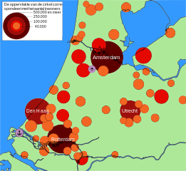
English: Map of towns and cities with more than 30.000 inhabitants in the central western Netherlands. The conurbation in this part of the country is known as the Randstad. The area (not diameter) of the circles correspond to the size of the population.
Number of inhabitants 500,000 and more
250,000 - 500,000
100,000 - 250,000
40,000 - 100,000
Map made with Inkscape. |
| Datum | (UTC) |
| Bron |
Dit bestand is afgeleid van: Randstad Population Bubbles.svg: |
| Auteur |
|
| Dit is een geretoucheerde foto, wat betekent dat de originele versie digitaal aangepast is. Het origineel kan hier bekeken worden: Randstad Population Bubbles.svg.
|
Licentie
Ik, de auteursrechthebbende van dit werk, maak het hierbij onder de volgende licenties beschikbaar:
Dit bestand is gelicenseerd onder de Creative Commons-licentie Naamsvermelding-Gelijk delen 3.0 Unported
- De gebruiker mag:
- Delen – het werk kopiëren, verspreiden en doorgeven
- Remixen – afgeleide werken maken
- Onder de volgende voorwaarden:
- naamsvermelding – U moet op een gepaste manier aan naamsvermelding doen, een link naar de licentie geven, en aangeven of er wijzigingen in het werk zijn aangebracht. U mag dit op elke redelijke manier doen, maar niet zodanig dat de indruk wordt gewekt dat de licentiegever instemt met uw werk of uw gebruik van zijn werk.
- Gelijk delen – Als u het werk heeft geremixt, veranderd, of erop heeft voortgebouwd, moet u het gewijzigde materiaal verspreiden onder dezelfde licentie als het oorspronkelijke werk, of een daarmee compatibele licentie.

|
Toestemming wordt verleend voor het kopiëren, verspreiden en/of wijzigen van dit document onder de voorwaarden van de GNU-licentie voor vrije documentatie, versie 1.2 of enige latere versie als gepubliceerd door de Free Software Foundation; zonder Invariant Sections, zonder Front-Cover Texts, en zonder Back-Cover Texts. Een kopie van de licentie is opgenomen in de sectie GNU-licentie voor vrije documentatie. |
U mag zelf één van de licenties kiezen.
Oorspronkelijk uploadlogboek
This image is a derivative work of the following images:
- File:Randstad_Population_Bubbles.svg licensed with Cc-by-sa-3.0, GFDL
- 2010-06-14T13:53:09Z Junuxx 2000x1841 (492883 Bytes) Improved legend and color scheme
- 2010-06-14T13:27:13Z Junuxx 2000x1841 (491623 Bytes) Added land/water color.
- 2010-06-12T02:57:06Z Junuxx 2000x1841 (393897 Bytes) Fixed a problem with unsupported flowRoot namespace. Also changed nominal size.
- 2010-06-12T02:02:27Z Junuxx 744x1052 (570256 Bytes) One more time.
- 2010-06-12T01:57:34Z Junuxx 744x1052 (570248 Bytes) Fixed image, hope it will actually show now.
- 2010-06-12T01:49:43Z Junuxx 744x1052 (155638 Bytes) {{Information |Description={{en|1=Map of towns and cities with more than 40.000 inhabitants in the central western Netherlands. The conurbation in this part of the country is known as the [[:en:Randstad|Randstad]]. The area (
Uploaded with derivativeFX
Bestandsgeschiedenis
Klik op een datum/tijd om het bestand te zien zoals het destijds was.
| Datum/tijd | Miniatuur | Afmetingen | Gebruiker | Opmerking | |
|---|---|---|---|---|---|
| huidige versie | 12 jul 2013 18:07 | | 2.000 × 1.841 (475 kB) | Richardw | bijschrift: 500.000 of meer |
| 8 mei 2012 13:23 |  | 2.000 × 1.841 (475 kB) | Karlfk | == {{int:filedesc}} == {{Information |Description={{en|1=Map of towns and cities with more than 30.000 inhabitants in the central western Netherlands. The conurbation in this part of the country is known as the Randstad. The area (not ... |
Bestandsgebruik
Dit bestand wordt op de volgende 3 pagina's gebruikt:
Globaal bestandsgebruik
De volgende andere wiki's gebruiken dit bestand:
- Gebruikt op de.wikivoyage.org
- Gebruikt op no.wikipedia.org
.svg)