Bestand:Pictus-Topography of Ankara.svg

Afmetingen van deze voorvertoning van het type PNG van dit SVG-bestand: 683 × 600 pixels Andere resoluties: 273 × 240 pixels | 547 × 480 pixels | 874 × 768 pixels | 1.166 × 1.024 pixels | 2.332 × 2.048 pixels | 1.890 × 1.660 pixels.
Oorspronkelijk bestand (SVG-bestand, nominaal 1.890 × 1.660 pixels, bestandsgrootte: 472 kB)
| Dit is een bestand van Wikimedia Commons. Onderstaande beschrijving komt van de beschrijving van het bestand daar. |
Beschrijving
| Beschrijving |
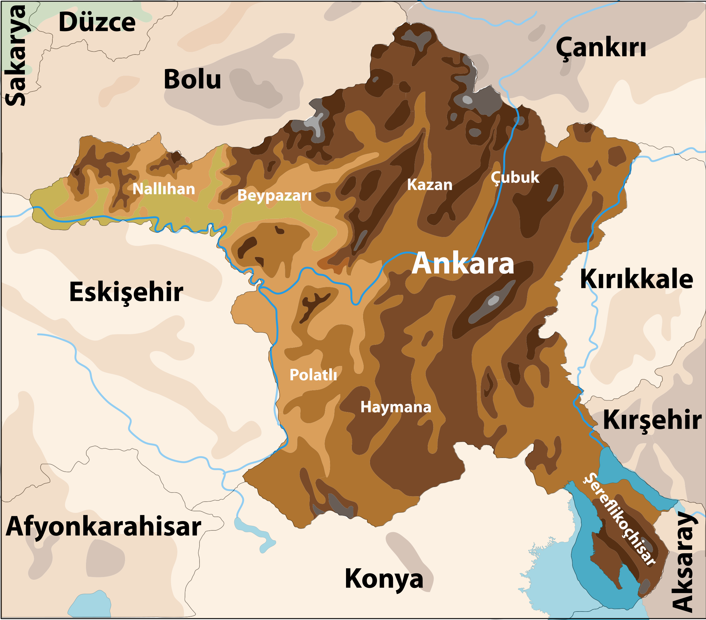
English: Topographic map of Ankara Province.
Türkçe: Ankara ilinin fiziki haritası. |
| Datum | |
| Bron | Eigen werk |
| Auteur |
|
Licentie
Ik, de auteursrechthebbende van dit werk, maak het hierbij onder de volgende licentie beschikbaar:
Dit bestand is gelicenseerd onder de Creative Commons-licentie Naamsvermelding 3.0 Unported
- De gebruiker mag:
- Delen – het werk kopiëren, verspreiden en doorgeven
- Remixen – afgeleide werken maken
- Onder de volgende voorwaarden:
- naamsvermelding – U moet op een gepaste manier aan naamsvermelding doen, een link naar de licentie geven, en aangeven of er wijzigingen in het werk zijn aangebracht. U mag dit op elke redelijke manier doen, maar niet zodanig dat de indruk wordt gewekt dat de licentiegever instemt met uw werk of uw gebruik van zijn werk.
Bestandsgeschiedenis
Klik op een datum/tijd om het bestand te zien zoals het destijds was.
| Datum/tijd | Miniatuur | Afmetingen | Gebruiker | Opmerking | |
|---|---|---|---|---|---|
| huidige versie | 2 jun 2010 18:22 | | 1.890 × 1.660 (472 kB) | The Emirr | The texts has been added. |
| 2 jun 2010 12:01 |  | 1.890 × 1.660 (424 kB) | The Emirr | The colors has been lighter. | |
| 29 mei 2010 19:51 |  | 1.890 × 1.660 (424 kB) | The Emirr | The rivers has been added. | |
| 29 mei 2010 19:49 |  | 1.890 × 1.660 (423 kB) | The Emirr | The size has been changed. | |
| 29 mei 2010 19:47 |  | 189 × 166 (355 kB) | The Emirr | The map has been made better. | |
| 14 mrt 2010 16:17 |  | 857 × 757 (377 kB) | The Emirr | ||
| 14 mrt 2010 16:07 |  | 857 × 757 (472 kB) | The Emirr | {{Information |Description={{en|1=Topographic map of Ankara Province.}} {{tr|1=Ankara ilinin fiziki haritası.}} |Source={{own}} |Author={{click|image=TheEmirr-Logo.png|link=User:The Emirr|width=60px|height=60px}} |Date=2010-03-14 |Permission={{The Emirr} |
Bestandsgebruik
Dit bestand wordt op de volgende pagina gebruikt:
Globaal bestandsgebruik
De volgende andere wiki's gebruiken dit bestand:
- Gebruikt op de.wikipedia.org
- Gebruikt op tr.wikipedia.org