Bestand:Philippine climate map.png

Grootte van deze voorvertoning: 384 × 599 pixels. Andere resoluties: 154 × 240 pixels | 308 × 480 pixels | 492 × 768 pixels | 656 × 1.024 pixels | 2.000 × 3.120 pixels.
Oorspronkelijk bestand (2.000 × 3.120 pixels, bestandsgrootte: 204 kB, MIME-type: image/png)
| Dit is een bestand van Wikimedia Commons. Onderstaande beschrijving komt van de beschrijving van het bestand daar. |
Beschrijving
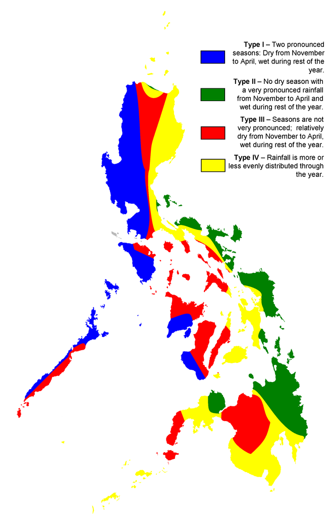
| Beschrijving | Map showing the ditribution of rainfall in the Philippines |
| Datum | |
| Bron | map created by user:Howard the Duck based on map of Philippine meteorological institute PAG-ASA; originally uploaded to English Wikipedia |
| Auteur | en:User:Howard the Duck |
| Toestemming (Hergebruik van dit bestand) |
CC-BY-2.5 |
| Andere versies | English Wikipedia |
Licentie
Dit bestand is gelicenseerd onder de Creative Commons-licentie Naamsvermelding 2.5 Unported
- De gebruiker mag:
- Delen – het werk kopiëren, verspreiden en doorgeven
- Remixen – afgeleide werken maken
- Onder de volgende voorwaarden:
- naamsvermelding – U moet op een gepaste manier aan naamsvermelding doen, een link naar de licentie geven, en aangeven of er wijzigingen in het werk zijn aangebracht. U mag dit op elke redelijke manier doen, maar niet zodanig dat de indruk wordt gewekt dat de licentiegever instemt met uw werk of uw gebruik van zijn werk.

|
Deze meteorology-afbeelding zou opnieuw moeten worden aangemaakt als een SVG-bestand door vectorafbeeldingen te gebruiken. Dit heeft een aantal voordelen; zie Commons:Media for cleanup voor meer informatie. Als er een SVG-formaat van deze afbeelding bestaat, dan deze graag uploaden. Nadat u dit heeft gedaan, gelieve dit sjabloon te vervangen door het sjabloon {{vector version available|nieuwe bestandsnaam.svg}} op deze afbeeldingspagina.
|
Bestandsgeschiedenis
Klik op een datum/tijd om het bestand te zien zoals het destijds was.
| Datum/tijd | Miniatuur | Afmetingen | Gebruiker | Opmerking | |
|---|---|---|---|---|---|
| huidige versie | 5 mrt 2007 00:10 | | 2.000 × 3.120 (204 kB) | Magalhães | {{Information |Description= |Source=map created by user:Howard the Duck based on map of Philippine meteorological institute [http://www.pagasa.dost.gov.ph/cab/coronas2.jpg PAG-ASA]; originally uploaded to English Wikipedia |Date=02/23/2007 |Author=[[:en:U |
Bestandsgebruik
Dit bestand wordt op de volgende pagina gebruikt:
Globaal bestandsgebruik
De volgende andere wiki's gebruiken dit bestand:
- Gebruikt op de.wikipedia.org
- Gebruikt op en.wikipedia.org
- Gebruikt op sq.wikipedia.org
- Gebruikt op uk.wikipedia.org