Bestand:Offa Kent map.gif
Geen hogere resolutie beschikbaar.
Offa_Kent_map.gif (552 × 390 pixels, bestandsgrootte: 69 kB, MIME-type: image/gif)
| Dit is een bestand van Wikimedia Commons. Onderstaande beschrijving komt van de beschrijving van het bestand daar. |
| Beschrijving |
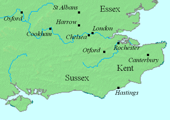
English: This map shows locations in southeastern England relevant to the article on Offa of Mercia.
This file was created using DMIS. On that site it is stated that "We do not claim copyright on the images, so you can use them for Wikipedia." |
||
| Datum | Uploaded to the English language Wikipedia in January 2008 (log) | ||
| Bron | en:Image:Offa Kent map.gif | ||
| Auteur | Mike Christie (talk) | ||
| Toestemming (Hergebruik van dit bestand) |
|
Bestandsgeschiedenis
Klik op een datum/tijd om het bestand te zien zoals het destijds was.
| Datum/tijd | Miniatuur | Afmetingen | Gebruiker | Opmerking | |
|---|---|---|---|---|---|
| huidige versie | 13 aug 2008 00:19 | | 552 × 390 (69 kB) | Elinnea | {{Information |Description=This map shows locations in southeastern England relevant to the article on Offa of Mercia. This file was created using [http://www.demis.nl/home/pages/home.htm DMIS]. On that site it is [http://support.demis.nl/forums/thr |
Bestandsgebruik
Dit bestand wordt op de volgende pagina gebruikt:
Globaal bestandsgebruik
De volgende andere wiki's gebruiken dit bestand:
- Gebruikt op arz.wikipedia.org
- Gebruikt op azb.wikipedia.org
- Gebruikt op ca.wikipedia.org
- Gebruikt op el.wikipedia.org
- Gebruikt op en.wikipedia.org
- Gebruikt op fa.wikipedia.org
- Gebruikt op id.wikipedia.org
- Gebruikt op ja.wikipedia.org
- Gebruikt op sv.wikipedia.org