Bestand:Netherlands, Veur, map of 1867.jpg

Oorspronkelijk bestand (2.340 × 1.996 pixels, bestandsgrootte: 1,79 MB, MIME-type: image/jpeg)
| Dit is een bestand van Wikimedia Commons. Onderstaande beschrijving komt van de beschrijving van het bestand daar. |
Beschrijving
| Beschrijving |
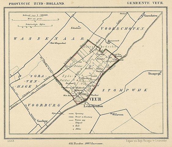
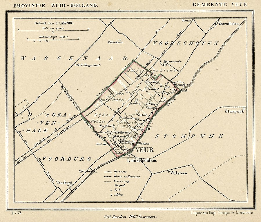
Nederlands: Kaart uit 1867 van de gemeente Veur (Zuid-Holland). Veur fuseerde in 1938 met Stompwijk tot Leidschendam.
English: Map from 1867 of the former municipality of Veur (Province of South Holland, Netherlands). In 1938 Veur merged with the municipality of Stompwijk to form Leidschendam. |
| Datum | 1867. Published around 1870 as part of a series of provincial atlases of the Netherlands. |
| Bron | Gemeente-atlas van Nederland naar officieele bronnen bewerkt. |
| Auteur | J. Kuyper |
| Toestemming (Hergebruik van dit bestand) |
This image is in the public domain. The author J. Kuyper died in 1908. [In the Netherlands copyright expires 70 years after the death of the author or 70 years after first publication in the case of anonymous or pseudonymous works or works published by a legal entity]. [Het auteursrecht in Nederland vervalt 70 jaar na de dood van de auteur of 70 jaar na de eerste openbaarmaking van het werk, indien het gaat om een anoniem of om een onder pseudoniem verschenen werk of werk van een rechtspersoon]. |
The church of Leidschendam (just south of Veur in the map) is located at:
| Cameralocatie | | Deze en andere afbeeldingen in: OpenStreetMap |
|---|
Licentie
|
Dit werk bevindt zich in het publiek domein in landen en gebieden waar de auteursrechttermijn het leven van de auteur plus 70 jaar of minder is.
| |
| Van dit bestand is vastgesteld dat er geen bekende auteursrechtaanspraken op rusten, alle aanverwante en naburige rechten daarbij inbegrepen. | |
Bestandsgeschiedenis
Klik op een datum/tijd om het bestand te zien zoals het destijds was.
| Datum/tijd | Miniatuur | Afmetingen | Gebruiker | Opmerking | |
|---|---|---|---|---|---|
| huidige versie | 13 dec 2011 23:31 | | 2.340 × 1.996 (1,79 MB) | Loranchet | {{Information |Description ={{nl|1=Kaart uit 1867 van de gemeente Veur (Zuid-Holland). Veur fuseerde in 1938 met Stompwijk tot Leidschendam.}} {{en|1=Map from 1867 of the former municipality of Veur (Province of South Holland, Netherlands). In 1938 Veu |
Bestandsgebruik
Dit bestand wordt op de volgende 2 pagina's gebruikt:
Globaal bestandsgebruik
De volgende andere wiki's gebruiken dit bestand:
- Gebruikt op en.wikipedia.org