Bestand:Map of USA AK full.png
Geen hogere resolutie beschikbaar.
Map_of_USA_AK_full.png (284 × 184 pixels, bestandsgrootte: 19 kB, MIME-type: image/png)
| Dit is een bestand van Wikimedia Commons. Onderstaande beschrijving komt van de beschrijving van het bestand daar. |

|
Bestand:Map of USA AK full.svg is een vectorversie van dit bestand. Indien niet van slechtere kwaliteit dient deze gebruikt te worden in plaats van deze rasterafbeelding.
File:Map of USA AK full.png → File:Map of USA AK full.svg
Zie Help:SVG voor meer informatie. |
 |
Beschrijving
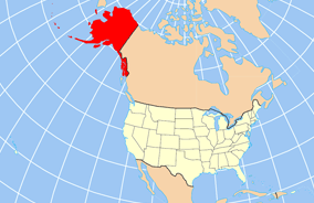
| Beschrijving | Map of USA with Alaska highlighted and shown in true position |
| Datum | |
| Bron | http://www.nationalatlas.gov/printable/reference.html |
| Auteur | |
| Andere versies | File:Map of USA AK full.svg |
Licentie
This map was obtained from an edition of the National Atlas of the United States. Like almost all works of the U.S. federal government, works from the National Atlas are in the public domain in the United States.
Online access: NationalAtlas.gov | 1970 print edition: Library of Congress, Perry-Castañeda Library
|
Bestandsgeschiedenis
Klik op een datum/tijd om het bestand te zien zoals het destijds was.
| Datum/tijd | Miniatuur | Afmetingen | Gebruiker | Opmerking | |
|---|---|---|---|---|---|
| huidige versie | 17 dec 2012 22:43 | | 284 × 184 (19 kB) | Ras67 | cropped |
| 2 apr 2007 18:31 |  | 286 × 186 (20 kB) | MattWright | fix to more standard map colors | |
| 2 apr 2007 08:20 |  | 286 × 186 (19 kB) | MattWright | {{Information |Description=Map of USA with Alaska highlighted and shown in true position |Source=http://www.nationalatlas.gov/printable/reference.html |Date=2007-04-02 |Author= |Permission= |other_versions= }} Category:Maps of the United States [[Cat |
Bestandsgebruik
Geen enkele pagina gebruikt dit bestand.
Globaal bestandsgebruik
De volgende andere wiki's gebruiken dit bestand:
- Gebruikt op am.wikipedia.org
- Gebruikt op ar.wikipedia.org
- Gebruikt op az.wikipedia.org
- Gebruikt op az.wiktionary.org
- Gebruikt op ba.wikipedia.org
- Gebruikt op bn.wikipedia.org
- Gebruikt op ce.wikipedia.org
- Gebruikt op cy.wikipedia.org
- Gebruikt op da.wikipedia.org
- Gebruikt op de.wikipedia.org
- Gebruikt op el.wikipedia.org
- Gebruikt op en.wikipedia.org
- Gebruikt op es.wikibooks.org
- Gebruikt op fa.wikipedia.org
- Gebruikt op fr.wikinews.org
- Gebruikt op ga.wikipedia.org
- Sitka
- Buirg Aleutians Thoir, Alasca
- Buirg Anchorage, Alasca
- Buirg Artach Thiar Thuaidh, Alasca
- Buirg Bristol Bay, Alasca
- Buirg Denali, Alasca
- Buirg Fairbanks Réalta Thuaidh, Alasca
- Buirg Haines, Alasca
- Buirg Juneau, Alasca
- Buirg Leithinis Kenai, Alasca
- Buirg Tairseach Ketchikan, Alasca
- Buirg Oileán Kodiak, Alasca
- Buirg Loch agus Leithinis, Alasca
- Buirg Matanuska-Susitna, Alasca
Globaal gebruik van dit bestand bekijken.