Bestand:Map of Lilliput - Gulliver's Travels 1726 edition.png

Grootte van deze voorvertoning: 352 × 599 pixels. Andere resoluties: 141 × 240 pixels | 400 × 681 pixels.
Oorspronkelijk bestand (400 × 681 pixels, bestandsgrootte: 187 kB, MIME-type: image/png)
| Dit is een bestand van Wikimedia Commons. Onderstaande beschrijving komt van de beschrijving van het bestand daar. |
Beschrijving
| Beschrijving |
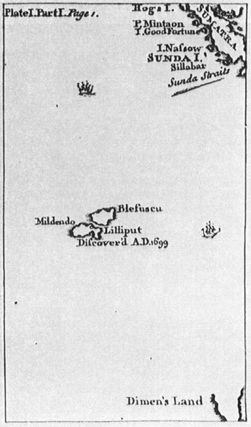
English: Map of Lilliput, for the 1726 edition of Jonathan Swift's Gulliver's Travels (or, Travels into Several Remote Nations of the World, 1726). Lilliput is situated south of Sumatra and north of "Dimen's Land" (Van Diemen's Land (Tasmania)?). Real islands in the far neigbourhood are nowadays the Cocos (Keeling) Islands (Australia) and Christmas Island (Great-Britain) and further south the pair Île Amsterdam (Amsterdam Island, Amsterdam or Nieuw-Amsterdam) and Île Saint-Paul at a distance of 85 km, which resemble the pair Blefuscu and Lilliput in the novel Gulliver's Travels. |
| Datum | |
| Bron | The 1726 edition of Jonathan Swift's Lemuel Gulliver's travels into several remote nations of the world |
| Auteur | Benjamin Motte, printer, after the style of Herman Moll |
Licentie
|
Het tweedimensionale kunstwerk afgebeeld op deze afbeelding valt in het publiek domein omdat:
Reproducties van het werk kunnen ook worden beschouwd als publiek domein omdat ze geen oorspronkelijk karakter hebben. Dit geldt voor reproducties gemaakt in de Verenigde Staten (zie Bridgeman Art Library v. Corel Corp.), Duitsland en veel andere landen.
| ||||
Bestandsgeschiedenis
Klik op een datum/tijd om het bestand te zien zoals het destijds was.
| Datum/tijd | Miniatuur | Afmetingen | Gebruiker | Opmerking | |
|---|---|---|---|---|---|
| huidige versie | 24 sep 2016 22:25 | | 400 × 681 (187 kB) | Cmdrjameson | Compressed with pngout. Reduced by 93kB (33% decrease). |
| 22 sep 2005 17:10 |  | 400 × 681 (281 kB) | Frank Schulenburg | Hermann Moll: ''Map of Lilliput'', for the 1726 edition of Jonathan Swift's ''Lemuel Gulliver's travels into several remote nations of the world'' {{Creator:Herman Moll}} |
Bestandsgebruik
Globaal bestandsgebruik
De volgende andere wiki's gebruiken dit bestand:
- Gebruikt op als.wikipedia.org
- Gebruikt op de.wikipedia.org
- Gebruikt op en.wikipedia.org
- Gebruikt op eo.wikipedia.org
- Gebruikt op eu.wikipedia.org
- Gebruikt op fa.wikipedia.org
- Gebruikt op fi.wikipedia.org
- Gebruikt op fr.wikipedia.org
- Gebruikt op hr.wikipedia.org
- Gebruikt op it.wikipedia.org
- Gebruikt op it.wikiquote.org
- Gebruikt op ko.wikipedia.org
- Gebruikt op pt.wikipedia.org
- Gebruikt op ru.wikipedia.org
- Gebruikt op sq.wikipedia.org
- Gebruikt op uk.wikipedia.org