Bestand:Map of Cesar (municipalities).png
Geen hogere resolutie beschikbaar.
Map_of_Cesar_(municipalities).png (230 × 544 pixels, bestandsgrootte: 102 kB, MIME-type: image/png)
| Dit is een bestand van Wikimedia Commons. Onderstaande beschrijving komt van de beschrijving van het bestand daar. |
.png)
Beschrijving
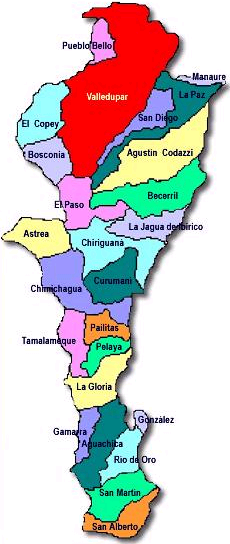
| Beschrijving | Map of Cesar, a department of Colombia. The map shows the municipalities. |
| Datum | (UTC) |
| Bron | 1, some changes by 08:30, 28 September 2006 (UTC) |
| Auteur | |
| Toestemming (Hergebruik van dit bestand) |
1 |
Licentie
| Dit bestand is gelicenseerd onder de Creative Commons-licentie Naamsvermelding-Gelijk delen 3.0 Unported Onderhevig aan disclaimers. | ||
| ||
| Deze licentietag is toegevoegd aan dit bestand in verband met de GFDL licentie-update. |

|
Toestemming wordt verleend voor het kopiëren, verspreiden en/of wijzigen van dit document onder de voorwaarden van de GNU-licentie voor vrije documentatie, versie 1.2 of enige latere versie als gepubliceerd door de Free Software Foundation; zonder Invariant Sections, zonder Front-Cover Texts, en zonder Back-Cover Texts. Een kopie van de licentie is opgenomen in de sectie GNU-licentie voor vrije documentatie. Onderhevig aan disclaimers. |
Bestandsgeschiedenis
Klik op een datum/tijd om het bestand te zien zoals het destijds was.
| Datum/tijd | Miniatuur | Afmetingen | Gebruiker | Opmerking | |
|---|---|---|---|---|---|
| huidige versie | 28 sep 2006 10:30 | | 230 × 544 (102 kB) | Ninane | {{Information| |Description= Map of Cesar, a department of Colombia. The map shows the municipalities. |Source=[http://en.wikipedia.org/wiki/Image:Cesarmunicipios.JPG 1], some changes by ~~~~~ |Date=~~~~~ |Author= |Permission=[http://en.wikipedia.org/wiki |
Bestandsgebruik
Dit bestand wordt op de volgende pagina gebruikt:
Globaal bestandsgebruik
De volgende andere wiki's gebruiken dit bestand:
- Gebruikt op fr.wikipedia.org
.png)