Bestand:Maharlika Highway map.png
Grootte van deze voorvertoning: 384 × 599 pixels. Andere resoluties: 154 × 240 pixels | 500 × 780 pixels.
Oorspronkelijk bestand (500 × 780 pixels, bestandsgrootte: 34 kB, MIME-type: image/png)
| Dit is een bestand van Wikimedia Commons. Onderstaande beschrijving komt van de beschrijving van het bestand daar. |
| Beschrijving |
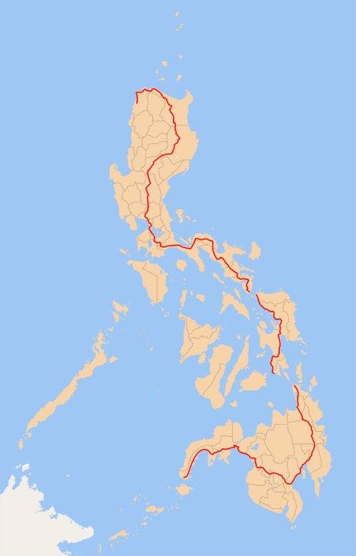
English: Map of the Philippines (with provincial borders in grey) showing the en:Pan-Philippine Highway (red). Ferry services connect Luzon to Samar and Leyte to Mindanao, and the en:San Juanico Bridge connects Samar and Leyte.
Made by me, released under the GFDL. |
||||||||
| Datum | 17 juni 2006 (originele uploaddatum) | ||||||||
| Bron | Verplaatst vanaf en.wikipedia naar Commons door Ludger1961 met behulp van CommonsHelper. | ||||||||
| Auteur | De originele uploader was TheCoffee op de Engelstalige Wikipedia | ||||||||
| Andere versies |
|

Oorspronkelijk uploadlogboek
De oorspronkelijke beschrijving van deze afbeelding stond hier. Alle volgende gebruikersnamen verwijzen naar en.wikipedia.
- 2006-06-17 16:04 TheCoffee 500×780× (34758 bytes) Map of the [[Philippines]] (with provincial borders in grey) showing the [[Pan-Philippine Highway]] (red). Ferry services connect Luzon to Samar and Leyte to Mindanao, and the [[San Joaquin Bridge]] connects Samar and Leyte. Made by him, released under th
Bestandsgeschiedenis
Klik op een datum/tijd om het bestand te zien zoals het destijds was.
| Datum/tijd | Miniatuur | Afmetingen | Gebruiker | Opmerking | |
|---|---|---|---|---|---|
| huidige versie | 6 jan 2009 09:28 | | 500 × 780 (34 kB) | File Upload Bot (Magnus Manske) | {{BotMoveToCommons|en.wikipedia}} {{Information |Description={{en|Map of the en:Philippines (with provincial borders in grey) showing the en:Pan-Philippine Highway (red). Ferry services connect Luzon to Samar and Leyte to Mindanao, and the [[:e |
Bestandsgebruik
Dit bestand wordt op de volgende pagina gebruikt:
Globaal bestandsgebruik
De volgende andere wiki's gebruiken dit bestand:
- Gebruikt op bcl.wikipedia.org
- Gebruikt op de.wikipedia.org
- Gebruikt op en.wikipedia.org
- Gebruikt op en.wikibooks.org
- Gebruikt op es.wikipedia.org
- Gebruikt op fr.wikipedia.org
- Gebruikt op id.wikipedia.org
- Gebruikt op it.wikipedia.org
- Gebruikt op no.wikipedia.org
- Gebruikt op th.wikipedia.org
- Gebruikt op tl.wikipedia.org
- Gebruikt op www.wikidata.org
- Gebruikt op zh.wikipedia.org