Bestand:Luxembourg administrative subdivisions coloured.gif
Grootte van deze voorvertoning: 444 × 599 pixels. Andere resoluties: 178 × 240 pixels | 600 × 809 pixels.
Oorspronkelijk bestand (600 × 809 pixels, bestandsgrootte: 30 kB, MIME-type: image/gif)
| Dit is een bestand van Wikimedia Commons. Onderstaande beschrijving komt van de beschrijving van het bestand daar. |
Beschrijving
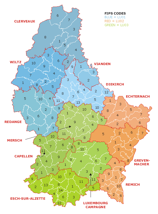
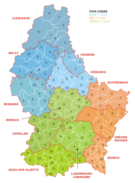
| Beschrijving | Map of the administrative divisions of Luxembourg. Districts, cantons, and communes are marked and numbered according to FIPS code. |
| Datum | |
| Bron | Own work based on w:Image:Luxembourg.geohive.gif, which previously had all rights released by its original author and publisher, GeoHive. Updated for the commune mergers of 2006-01-01. |
| Auteur | User:Bastin8 |
| Toestemming (Hergebruik van dit bestand) |
Released into public domain. See licence below. |
Licentie
| Ik, de auteursrechthebbende van dit werk, geef dit werk vrij in het publieke domein. Dit is wereldwijd van toepassing. In sommige landen is dit wettelijk niet mogelijk; in die gevallen geldt: Ik sta iedereen toe dit werk voor eender welk doel te gebruiken, zonder enige voorwaarden, tenzij zulke voorwaarden door de wet worden voorgeschreven. |
Bestandsgeschiedenis
Klik op een datum/tijd om het bestand te zien zoals het destijds was.
| Datum/tijd | Miniatuur | Afmetingen | Gebruiker | Opmerking | |
|---|---|---|---|---|---|
| huidige versie | 21 jul 2006 02:19 | | 600 × 809 (30 kB) | Bastin8 | {{Information |Description=Map of the administrative divisions of Luxembourg. Districts, cantons, and communes are marked and numbered according to FIPS code. |Source=Own work based on w:Image:Luxembourg.geohive.gif, which previously had all rights r |
Bestandsgebruik
Dit bestand wordt op de volgende pagina gebruikt:
Globaal bestandsgebruik
De volgende andere wiki's gebruiken dit bestand:
- Gebruikt op an.wikipedia.org
- Gebruikt op ast.wikipedia.org
- Gebruikt op es.wikipedia.org
- Gebruikt op eu.wikipedia.org
- Gebruikt op fur.wikipedia.org
- Gebruikt op gag.wikipedia.org
- Gebruikt op id.wikipedia.org
- Gebruikt op it.wikipedia.org
- Gebruikt op kk.wikipedia.org
- Gebruikt op ko.wikipedia.org
- Gebruikt op lt.wikipedia.org
- Gebruikt op mk.wikipedia.org
- Gebruikt op pt.wikipedia.org
- Gebruikt op ro.wikipedia.org
- Gebruikt op ru.wikipedia.org
- Gebruikt op sco.wikipedia.org
- Gebruikt op sq.wikipedia.org
- Gebruikt op tr.wikipedia.org
- Gebruikt op uz.wikipedia.org
- Gebruikt op zh.wikipedia.org