Bestand:Limpopo 2001 dominant language map.svg

Afmetingen van deze voorvertoning van het type PNG van dit SVG-bestand: 800 × 530 pixels Andere resoluties: 320 × 212 pixels | 640 × 424 pixels | 1.024 × 679 pixels | 1.280 × 848 pixels | 2.560 × 1.697 pixels | 1.228 × 814 pixels.
Oorspronkelijk bestand (SVG-bestand, nominaal 1.228 × 814 pixels, bestandsgrootte: 812 kB)
| Dit is een bestand van Wikimedia Commons. Onderstaande beschrijving komt van de beschrijving van het bestand daar. |
Beschrijving
| Beschrijving |
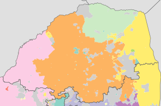
English: Map showing the dominant home languages in Limpopo province of South Africa, according to Census 2001 at the "Subplace" level. In this context, a language is dominant if it more than 50% of the population in an area speak it at home, or more than 33% speak it and no other language is spoken by more than 25%.
Afrikaans
English
isiNdebele
isiXhosa
isiZulu
Sesotho sa Leboa
Sesotho
Setswana
siSwati
Tshivenda
Xitsonga
No language dominant |
| Datum | |
| Bron | Statistics South Africa's Census 2001 is the source of the basic population data. The map results from my own processing of the data. |
| Auteur | Htonl |
Licentie
The following license applies to the population data on which the map is based:

|
De auteursrechthebbende van dit bestand, Stats SA, staat iedereen toe het voor willekeurig welk doel te gebruiken, mits de auteursrechthebbende correct met naam wordt genoemd.
Heruitgave, afgeleide werken, commercieel gebruik en alle andere vormen van gebruik zijn toegestaan. |
Naamsvermelding:
"the user acknowledges Stats SA as the source of the basic data wherever they process, apply, utilise, publish or distribute the data, and also that they specify that the relevant application and analysis (where applicable) result from their own processing of the data" [1]
|
The following tag applies to the map itself:
| Ik, de auteursrechthebbende van dit werk, geef dit werk vrij in het publieke domein. Dit is wereldwijd van toepassing. In sommige landen is dit wettelijk niet mogelijk; in die gevallen geldt: Ik sta iedereen toe dit werk voor eender welk doel te gebruiken, zonder enige voorwaarden, tenzij zulke voorwaarden door de wet worden voorgeschreven. |
Bestandsgeschiedenis
Klik op een datum/tijd om het bestand te zien zoals het destijds was.
| Datum/tijd | Miniatuur | Afmetingen | Gebruiker | Opmerking | |
|---|---|---|---|---|---|
| huidige versie | 5 okt 2010 07:50 | | 1.228 × 814 (812 kB) | Htonl | equal-area projection, map styling |
| 16 feb 2010 13:08 |  | 1.136 × 692 (1,67 MB) | Htonl | size | |
| 15 feb 2010 22:25 |  | 1.000 × 609 (1,77 MB) | Htonl | tweak | |
| 15 feb 2010 22:19 |  | 1.000 × 609 (1,77 MB) | Htonl | fix errors | |
| 10 feb 2010 23:55 |  | 1.000 × 609 (1,7 MB) | Htonl | =={{int:filedesc}}== {{Information |Description={{en|1=Map showing the dominant home languages in Limpopo province of South Africa, according to Census 2001 at the "Subplace" level. In this context, a language is dominant if it more than 50% of the popula |
Bestandsgebruik
Dit bestand wordt op de volgende pagina gebruikt:
Globaal bestandsgebruik
De volgende andere wiki's gebruiken dit bestand:
- Gebruikt op af.wikipedia.org
- Gebruikt op ca.wikipedia.org
- Gebruikt op de.wikipedia.org
- Gebruikt op en.wikipedia.org
- Gebruikt op frr.wikipedia.org
- Gebruikt op he.wikipedia.org
- Gebruikt op hy.wikipedia.org
- Gebruikt op ja.wikipedia.org
- Gebruikt op ka.wikipedia.org
- Gebruikt op nso.wikipedia.org
- Gebruikt op ru.wikipedia.org
- Gebruikt op zu.wikipedia.org