Bestand:Kent UK location map.svg

Afmetingen van deze voorvertoning van het type PNG van dit SVG-bestand: 800 × 561 pixels Andere resoluties: 320 × 225 pixels | 640 × 449 pixels | 1.024 × 719 pixels | 1.280 × 898 pixels | 2.560 × 1.796 pixels | 1.425 × 1.000 pixels.
Oorspronkelijk bestand (SVG-bestand, nominaal 1.425 × 1.000 pixels, bestandsgrootte: 2,11 MB)
| Dit is een bestand van Wikimedia Commons. Onderstaande beschrijving komt van de beschrijving van het bestand daar. |
| Beschrijving |
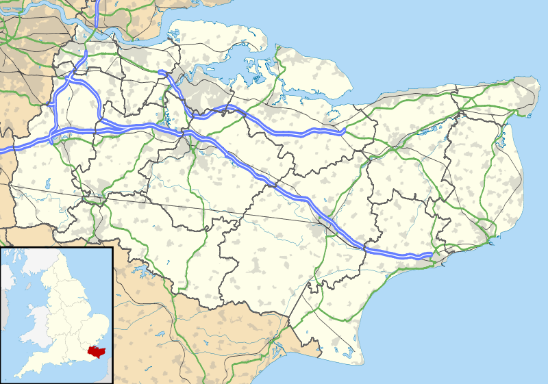
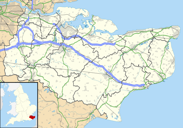
Map of Kent, UK with the following information shown:
Equirectangular map projection on WGS 84 datum, with N/S stretched 160% Geographic limits:
|
| Datum | |
| Bron |
|
| Auteur | Nilfanion, created using Ordnance Survey data |
| Toestemming (Hergebruik van dit bestand) |
Dit bestand is gelicenseerd onder de Creative Commons-licentie Naamsvermelding-Gelijk delen 3.0 Unported Naamsvermelding: Contains Ordnance Survey data © Crown copyright and database right
|
| Andere versies | File:Kent UK district map (blank).svg - Blank map |
.svg)
Bestandsgeschiedenis
Klik op een datum/tijd om het bestand te zien zoals het destijds was.
| Datum/tijd | Miniatuur | Afmetingen | Gebruiker | Opmerking | |
|---|---|---|---|---|---|
| huidige versie | 26 sep 2010 20:58 | | 1.425 × 1.000 (2,11 MB) | Nilfanion | {{Information |Description=Map of Kent, UK with the following information shown: *Administrative borders *Coastline, lakes and rivers *Roads and railways *Urban areas Equirectangular map projection on WGS 84 datum, with N/S stretched 160% Geo |
Bestandsgebruik
Meer dan 100 pagina's gebruiken dit bestand. De volgende lijst geeft alleen de eerste 100 pagina's weer die dit bestand gebruiken. Er is ook een volledige lijst beschikbaar.
- Acrise
- Adisham
- Aldington (Kent)
- Alkham
- Allhallows (Kent)
- Appledore
- Ashford (Engeland)
- Aylesford
- Aylesham
- Bapchild
- Barming
- Bearsted
- Bekesbourne-with-Patrixbourne
- Benenden
- Bethersden
- Bicknor
- Bidborough
- Biddenden
- Bilsington
- Birchington-on-Sea
- Bobbing
- Bonnington
- Borough Green
- Boughton Aluph
- Boughton Malherbe
- Boughton Monchelsea
- Boughton under Blean
- Boxley
- Brabourne
- Brasted
- Bredgar
- Bredhurst
- Brenchley
- Brenzett
- Broadstairs
- Burham
- Burmarsh
- Canterbury (Verenigd Koninkrijk)
- Chatham (Kent)
- Chilham
- Cobham (Kent)
- Cranbrook (Engeland)
- Dartford (plaats)
- Deal (Kent)
- Dover (Engeland)
- Drellingore
- East Langdon
- Eastry
- Edenbridge (Kent)
- Eythorne
- Faversham
- Folkestone
- Fordwich
- Frindsbury
- Gillingham (Kent)
- Goudhurst
- Grain Tower Battery
- Gravesend
- Greenhithe
- Herne (Engeland)
- Herne Bay (Kent)
- High Halstow
- Higham (Kent)
- Hildenborough
- Hoo St. Werburgh
- Hythe (Kent)
- Ightham
- Isle of Grain
- Kingsdown (Kent)
- Lamberhurst
- Maidstone
- Margate (Engeland)
- Minster-in-Thanet
- New Romney
- Otford
- Paddock Wood
- Pembury
- Queenborough
- Rainham (Kent)
- Ramsgate
- Richborough
- Rochester (Kent)
- Royal Tunbridge Wells
- Sandgate (Kent)
- Sandwich (Engeland)
- Sevenoaks (plaats)
- Sheerness
- Shoreham (Kent)
- Sissinghurst
- Sittingbourne
- Southborough
- Staplehurst (Kent)
- Strood
- Sturry
- Swanley
- Tenterden (Kent)
- Tonbridge
- Walmer
- West Kingsdown
- Whitstable
Meer koppelingen naar dit bestand bekijken.
Globaal bestandsgebruik
De volgende andere wiki's gebruiken dit bestand:
- Gebruikt op ar.wikipedia.org
- Gebruikt op bg.wikipedia.org
- Gebruikt op br.wikipedia.org
- Gebruikt op ca.wikipedia.org
- Gebruikt op ceb.wikipedia.org
- Gebruikt op cs.wikipedia.org
- Gebruikt op cy.wikipedia.org
- Gebruikt op el.wikipedia.org
- Gebruikt op en.wikipedia.org
- Lullingstone Roman Villa
- Dover
- Canterbury
- Chatham, Kent
- Dartford Crossing
- Hever Castle
- Leeds Castle
- Sandwich, Kent
- Folkestone
- Minster-in-Thanet
- Aylesford
- Maidstone
- Rochester, Kent
- Snodland
- Romney Marsh
- Dover Castle
- Walmer Castle
- Walmer
- Wye, Kent
- Isle of Sheppey
- Bedgebury National Pinetum
- Gravesend
- Eythorne
- Ramsgate
- Herne Bay
- Sevenoaks
- Tonbridge
- Stansted, Kent
- Royal Tunbridge Wells
- Ashford, Kent
- Broadstairs
- Hythe, Kent
- Queenborough
- New Romney
- Whitstable
- Otford
- Paddock Wood
- Knole
Globaal gebruik van dit bestand bekijken.