Bestand:Karte Kanton Appenzell Innerrhoden.png
Grootte van deze voorvertoning: 626 × 600 pixels. Andere resoluties: 251 × 240 pixels | 501 × 480 pixels | 1.003 × 961 pixels.
Oorspronkelijk bestand (1.003 × 961 pixels, bestandsgrootte: 156 kB, MIME-type: image/png)
| Dit is een bestand van Wikimedia Commons. Onderstaande beschrijving komt van de beschrijving van het bestand daar. |
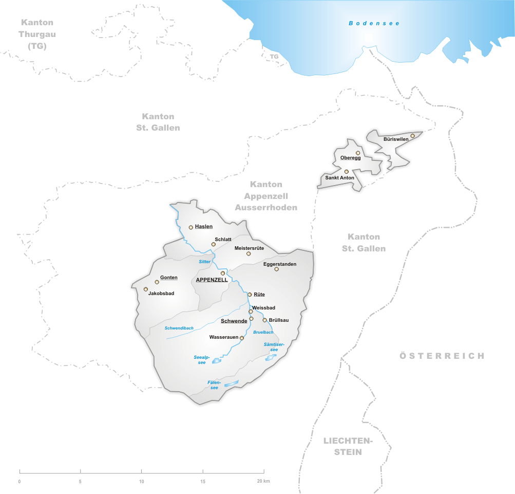
Deutsch: Karte des Kantons Appenzell Innerrhoden.
English: Map of canton Appenzell Innerrhoden.
drawn by/gezeichnet von de:Benutzer:Tschubby 12. Aug 2004

|
Toestemming wordt verleend voor het kopiëren, verspreiden en/of wijzigen van dit document onder de voorwaarden van de GNU-licentie voor vrije documentatie, versie 1.2 of enige latere versie als gepubliceerd door de Free Software Foundation; zonder Invariant Sections, zonder Front-Cover Texts, en zonder Back-Cover Texts. Een kopie van de licentie is opgenomen in de sectie GNU-licentie voor vrije documentatie. |
| Dit bestand is gelicenseerd onder de Creative Commons-licentie Naamsvermelding-Gelijk delen 3.0 Unported | ||
| ||
| Deze licentietag is toegevoegd aan dit bestand in verband met de GFDL licentie-update. |
Bestandsgeschiedenis
Klik op een datum/tijd om het bestand te zien zoals het destijds was.
| Datum/tijd | Miniatuur | Afmetingen | Gebruiker | Opmerking | |
|---|---|---|---|---|---|
| huidige versie | 30 aug 2005 21:04 | | 1.003 × 961 (156 kB) | Tschubby | |
| 30 aug 2005 20:54 |  | 1.003 × 961 (156 kB) | Tschubby | ||
| 30 aug 2005 18:48 |  | 1.003 × 961 (134 kB) | Tschubby | ||
| 15 apr 2005 22:45 |  | 826 × 785 (124 kB) | Wikibob~commonswiki | *'''de'': Karte Kanton Appenzell Innerrhoden. *'''en'': Map of Appenzell Innerrhoden. *Artist: drawn by/selbstgezeichnet von de:Benutzer:Tschubby 12. Aug 2004 *Licence/Lizenz: GNU-FDL *Source/Quelle: http://upload.wikimedia.org/wikipedia/de/5/54/Kar |
Bestandsgebruik
Dit bestand wordt op de volgende pagina gebruikt:
Globaal bestandsgebruik
De volgende andere wiki's gebruiken dit bestand:
- Gebruikt op de.wikipedia.org
- Gebruikt op hr.wikipedia.org
- Gebruikt op id.wikipedia.org
- Gebruikt op ja.wikipedia.org
- Gebruikt op jv.wikipedia.org
- Gebruikt op la.wikipedia.org
- Gebruikt op li.wikipedia.org
- Gebruikt op pl.wikipedia.org
- Gebruikt op pms.wikipedia.org
- Gebruikt op pnb.wikipedia.org
- Gebruikt op pt.wikipedia.org
- Gebruikt op rm.wikipedia.org