Bestand:Java Locator Topography.png

Grootte van deze voorvertoning: 800 × 515 pixels. Andere resoluties: 320 × 206 pixels | 640 × 412 pixels | 1.024 × 660 pixels | 1.280 × 825 pixels | 2.525 × 1.627 pixels.
Oorspronkelijk bestand (2.525 × 1.627 pixels, bestandsgrootte: 1,36 MB, MIME-type: image/png)
| Dit is een bestand van Wikimedia Commons. Onderstaande beschrijving komt van de beschrijving van het bestand daar. |
Beschrijving
| Beschrijving |
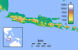
Topographic location map of Java (Indonesia). Created with GMT from SRTM data Left: 104.5, Right: 117.0, Bottom: -12.0666667 Top: -4.0. For non-locator version, see Image:Java Topography.png |
| Datum | |
| Bron | Eigen werk |
| Auteur | Sadalmelik |
Licentie
| Ik, de auteursrechthebbende van dit werk, geef dit werk vrij in het publieke domein. Dit is wereldwijd van toepassing. In sommige landen is dit wettelijk niet mogelijk; in die gevallen geldt: Ik sta iedereen toe dit werk voor eender welk doel te gebruiken, zonder enige voorwaarden, tenzij zulke voorwaarden door de wet worden voorgeschreven. |
Bestandsgeschiedenis
Klik op een datum/tijd om het bestand te zien zoals het destijds was.
| Datum/tijd | Miniatuur | Afmetingen | Gebruiker | Opmerking | |
|---|---|---|---|---|---|
| huidige versie | 9 jun 2010 00:24 | | 2.525 × 1.627 (1,36 MB) | Ras67 | cropped |
| 30 aug 2007 20:13 |  | 2.546 × 1.644 (1,37 MB) | Sadalmelik | {{Information |Description=Topographic location map of Java (Indonesia). Created with GMT from SRTM data Left: 104.5, Right: 117.0, Bottom: -12.0666667 Top: -4.0 |Source=self-made |Date=30 August, 2007 |Author= Sadalmelik }} [[Categor |
Bestandsgebruik
Dit bestand wordt op de volgende pagina gebruikt:
Globaal bestandsgebruik
De volgende andere wiki's gebruiken dit bestand:
- Gebruikt op an.wikipedia.org
- Gebruikt op ar.wikipedia.org
- Gebruikt op ceb.wikipedia.org
- Gebruikt op cs.wikipedia.org
- Gebruikt op en.wikipedia.org
- Gebruikt op es.wikipedia.org
- Gebruikt op fr.wikipedia.org
- Temple de Borobudur
- Merapi
- Bromo
- Caldeira Tengger
- Îles Karimunjawa
- Wilis
- Kamojang
- Mont Gede
- Mont Penanggungan
- Parc national d'Ujung Kulon
- Péninsule de Blambangan
- Semeru
- Merapi (Ijen)
- Kawah Ijen
- Guntur (Indonésie)
- Parc national de Meru Betiri
- Arjuno-Welirang
- Lawu
- Homme de Java
- Kelud
- Raung
- Plateau de Dieng
- Parc national de Bromo-Tengger-Semeru
- Butak
- Kawi (volcan)
- Argapura
- Parc national d'Alas Purwo
- Baluran
- Parc national de Baluran
- Segara Anakan
- Slamet
- Massacre de Rawagede
- Ciremai
- Parc national Halimun Salak
Globaal gebruik van dit bestand bekijken.