Bestand:Italy and Illyria 1084 AD.svg

Afmetingen van deze voorvertoning van het type PNG van dit SVG-bestand: 478 × 600 pixels Andere resoluties: 191 × 240 pixels | 383 × 480 pixels | 612 × 768 pixels | 816 × 1.024 pixels | 1.633 × 2.048 pixels | 586 × 735 pixels.
Oorspronkelijk bestand (SVG-bestand, nominaal 586 × 735 pixels, bestandsgrootte: 522 kB)
| Dit is een bestand van Wikimedia Commons. Onderstaande beschrijving komt van de beschrijving van het bestand daar. |

Beschrijving
| Beschrijving |
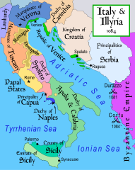
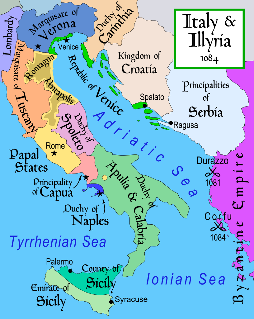
English: Map of Italy and the Illyrian coast in the year 1084.
Part of a series of maps on the history of Italy:
|
| Datum | |
| Bron | Eigen werk |
| Auteur | MapMaster |
| Andere versies |
[]
|
| SVG ontwikkeling | De broncode van dit SVG-bestand is deugdelijk. |


References
- This map from Allyn & Bacon, Longman, textbook publishers.
- Bjorklund, Oddvar; Holmboe, Haakon; Rohr, Anders (1970) Historical Atlas of the World, Barnes & Noble, NY, SBN: 389-00253-4.
- Hammond Atlas Corporation (2007) Hammond Historical World Atlas.
- Matthew, Donald (1989) Atlas of Medieval Europe, Time-Life Books.
- This map of 1000 AD Italy from Fordham University, adapted from Muir's Historical Atlas, (1911).
- This map of 1050 AD Italy, from the 1923 The Historical Atlas by William R. Shepherd
- This Wikipedia map of the w:en:Holy Roman Empire
- Šišić, Ferdo (1990) Povijest Hrvata u vrijeme narodnih vladara & the Baška tablet (to denote the territorial integrity of Croatia; islands, coastal borders etc.)
Licentie
Ik, de auteursrechthebbende van dit werk, maak het hierbij onder de volgende licentie beschikbaar:
Dit bestand is gelicenseerd onder de Creative Commons-licentie Naamsvermelding-Gelijk delen 2.5 Unported
- De gebruiker mag:
- Delen – het werk kopiëren, verspreiden en doorgeven
- Remixen – afgeleide werken maken
- Onder de volgende voorwaarden:
- naamsvermelding – U moet op een gepaste manier aan naamsvermelding doen, een link naar de licentie geven, en aangeven of er wijzigingen in het werk zijn aangebracht. U mag dit op elke redelijke manier doen, maar niet zodanig dat de indruk wordt gewekt dat de licentiegever instemt met uw werk of uw gebruik van zijn werk.
- Gelijk delen – Als u het werk heeft geremixt, veranderd, of erop heeft voortgebouwd, moet u het gewijzigde materiaal verspreiden onder dezelfde licentie als het oorspronkelijke werk, of een daarmee compatibele licentie.
derivative works
Afgeleide werken van dit bestand: Italy and Illyria 1084 v2-ar.svg
Bestandsgeschiedenis
Klik op een datum/tijd om het bestand te zien zoals het destijds was.
| Datum/tijd | Miniatuur | Afmetingen | Gebruiker | Opmerking | |
|---|---|---|---|---|---|
| huidige versie | 22 okt 2017 21:19 | | 586 × 735 (522 kB) | Ras67 | frame removed |
| 23 nov 2011 14:16 |  | 588 × 735 (644 kB) | Kathovo | Reverted to version as of 12:20, 29 July 2007 not an svg | |
| 23 jan 2011 20:06 |  | 480 × 600 (224 kB) | Er-vet-en | whoops, sorry for this | |
| 23 jan 2011 20:04 |  | 480 × 600 (224 kB) | Er-vet-en | resize | |
| 23 jan 2011 19:50 |  | 744 × 1.052 (224 kB) | Er-vet-en | plit and some islands are are actually in Croatia's dominion from about 1076 (since the previous map relied on maps from earlier) This is proven by the acclaimed historian Ferdo Šišić, and the culturally significant Bashka tablet (which proved that ki | |
| 29 jul 2007 14:20 |  | 588 × 735 (644 kB) | Lokal Profil | Cleaned up code (specifically loads of empty groups) | |
| 15 apr 2007 07:43 |  | 588 × 735 (695 kB) | MapMaster | Minor changes | |
| 13 feb 2007 05:56 |  | 588 × 735 (694 kB) | MapMaster | Map of Italy and the Illyrian coast in the year 1084 |
Bestandsgebruik
Geen enkele pagina gebruikt dit bestand.
Globaal bestandsgebruik
De volgende andere wiki's gebruiken dit bestand:
- Gebruikt op ar.wikipedia.org
- Gebruikt op azb.wikipedia.org
- Gebruikt op bg.wikipedia.org
- Gebruikt op bn.wikipedia.org
- Gebruikt op bs.wikipedia.org
- Gebruikt op ca.wikipedia.org
- Gebruikt op cs.wikipedia.org
- Gebruikt op da.wikipedia.org
- Gebruikt op de.wikipedia.org
- Gebruikt op el.wikipedia.org
- Gebruikt op en.wikipedia.org
- Gebruikt op et.wikipedia.org
Globaal gebruik van dit bestand bekijken.