Honduras_carte.png(328 × 352 pixels, bestandsgrootte: 34 kB, MIME-type: image/png)


Beschrijving

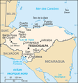
Beschrijving Map in French of Honduras
Datum translation : September 2006
Bron CIA World Factbook
Auteur of the translation : Eric Gaba (Sting)
Toestemming
(Hergebruik van dit bestand)
PD
Andere versies original English version : Image:Honduras-CIA_WFB_Map.png


Français : * Sujet : Carte en français du Honduras ;

Licentie

Public domain
Deze afbeelding bevindt zich in het publiek domein omdat het materiaal bevat dat oorspronkelijk afkomstig is van het CIA World Factbook.

Bahasa Indonesia  čeština  Deutsch  eesti  English  español  Esperanto  français  galego  hrvatski  italiano  Nederlands  norsk nynorsk  polski  português  sicilianu  slovenščina  suomi  Türkçe  Zazaki  беларуская (тарашкевіца)  македонски  русский  српски / srpski  українська  ქართული  বাংলা  தமிழ்  മലയാളം  한국어  日本語  中文  中文(简体)  中文(繁體)  العربية  +/−


Public domain This work was previously under Public Domain, or a Free License. It has been digitally enhanced and/or modified. This derivative work has been (or is hereby) released into the public domain by its author, Sting at the French Wikipedia project. This applies worldwide.

In some countries this is not legally possible; if so:
Sting grants anyone the right to use this work for any purpose, without any conditions, unless such conditions are required by law.


English  简体中文‎  繁體中文‎  +/−

Bestandsgeschiedenis

Klik op een datum/tijd om het bestand te zien zoals het destijds was.

Datum/tijdMiniatuurAfmetingenGebruikerOpmerking
huidige versie5 sep 2006 17:24Miniatuurafbeelding voor de versie van 5 sep 2006 17:24328 × 352 (34 kB)Sting{{Information |Description=Map in French of Honduras |Source=[https://www.cia.gov/cia/publications/factbook/index.html CIA World Factbook] |Date=translation : September 2006 |Author=of the translation : Eric Gaba (Sting) |Permission=PD |oth

Dit bestand wordt op de volgende pagina gebruikt:

Globaal bestandsgebruik

De volgende andere wiki's gebruiken dit bestand: