Bestand:Heathrow Before World War II Map.jpg
Oorspronkelijk bestand (1.422 × 740 pixels, bestandsgrootte: 398 kB, MIME-type: image/jpeg)
| Dit is een bestand van Wikimedia Commons. Onderstaande beschrijving komt van de beschrijving van het bestand daar. |
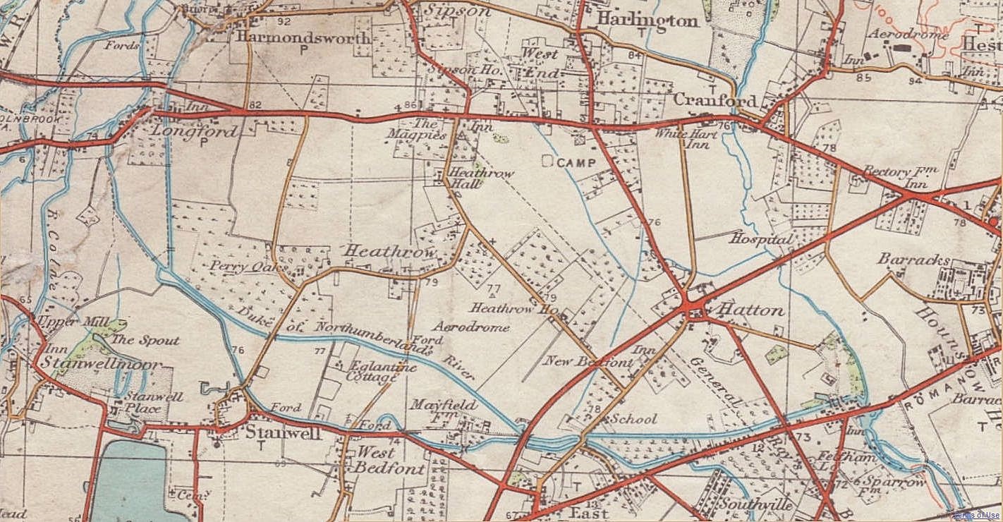
Beschrijving
This map is an extract of an old Ordnance Survey map from before World War II which is out of copyright. See Licensing below for details of the source of this image. --DavidCane 23:55, 18 February 2007 (UTC)
Caesar's Camp, wrongly attributed
The camp marked was one of the many supposed "Caesar's Camps", also called Schapsbury Hill and Shasbury Hill, a square, Early Iron Age, British (not Roman) fort site of c. 500 BC, south of Bath Road, about halfway between Heathrow Road and Hatton Road, and a bit north of due east of Heathrow Hall. It was about (90 m) square (c. 1820 measurement) or (120 m) square (1911 measurement). It survived because it was on common land until the enclosure of the Commons of Harmondsworth parish in 1819, after which the fort's ramparts were mostly and fairly quickly ploughed out.
It was excavated hurriedly in 1944: see timeline in the article on Heathrow (hamlet). Inside its rampart 15 circular hut sites were found, and a large rectangular building which was probably a temple. The east end of the north runway obliterated it.
Road names
- Red (arterial)
- Bath Road: the quite straight, east-west road. Note the slight fork formed by the 1926-built Colnbrook (and Longford) by-pass.
- Yellow (non-arterial)
- Cain's Lane: northeast of the aerodrome. It ran 1950 metres. Its south end stays as a suburban street in New Bedfont and opposite the Great South West Road for 150 metres as a Heathrow internal minor vehicle track. A farming family was associated with it including Isaac Cane or Cain. On Enclosure of the Commons into farmland in 1819, he was awarded land to found Cain's Farm.
- High Tree Lane: narrow lane west of the aerodrome. It ran 630 metres to a ford and footbridge over the Duke of Northumberland's River.
- That ford officially was called Goathouse Tree Ford, but the local people called the ford area High Tree River/Ford.
- Goathouse Road: runs 770 metres south from that ford into Long Lane (West Bedfont, Stanwell). May have been named after an enclosure called Goathouse Close which was in the area before.
- Heathrow Road: runs south past Heathrow Hall former farmstead, then turns west forking in Perry Oaks farm. A narrow yard east of The Three Magpies pub (into its car park) is a narrowed remnant of its north end: see Google Earth map link. It briefly dates to the era of road numbering, namely as the B379.
- Hatton Road: the road at a \-type angle to the right of the word CAMP and running to Hatton. Its ends exist now (see this Google Earth map). Vestiges persist: partly-overgrown tarmac and (as on Google Earth's files at 3 January 2012); a crop mark on grass at the east end of the north runway; alignments of airport service buildings; the south part of the airport internal road Eastchurch Road.
- Tithe Barn Lane: road from Perry Oaks almost due north.
- Oaks Road: road from Perry Oaks southward. A bit of its south end survives in Stanwell. Once part of the B379 road.
- White (tracks)
- Long Lane (Heathrow): lane or track leading west from Tithe Barn Lane then north to the Bath Road at the edge of Longford.
Licentie
- De gebruiker mag:
- Delen – het werk kopiëren, verspreiden en doorgeven
- Remixen – afgeleide werken maken
- Onder de volgende voorwaarden:
- naamsvermelding – U moet op een gepaste manier aan naamsvermelding doen, een link naar de licentie geven, en aangeven of er wijzigingen in het werk zijn aangebracht. U mag dit op elke redelijke manier doen, maar niet zodanig dat de indruk wordt gewekt dat de licentiegever instemt met uw werk of uw gebruik van zijn werk.
- Gelijk delen – Als u het werk heeft geremixt, veranderd, of erop heeft voortgebouwd, moet u het gewijzigde materiaal verspreiden onder dezelfde licentie als het oorspronkelijke werk, of een daarmee compatibele licentie.
Bestandsgeschiedenis
Klik op een datum/tijd om het bestand te zien zoals het destijds was.
| Datum/tijd | Miniatuur | Afmetingen | Gebruiker | Opmerking | |
|---|---|---|---|---|---|
| huidige versie | 4 dec 2013 11:08 | | 1.422 × 740 (398 kB) | Anthony Appleyard | The previous image, sharpened in Paintshop Pro, and some wear damage (to the original paper map) repaired along the river Colne near the west edge. |
| 5 feb 2012 14:05 |  | 1.422 × 740 (208 kB) | Anthony Appleyard | More area | |
| 5 okt 2008 00:35 |  | 525 × 368 (158 kB) | DavidCane | ==Summary== This map is an extract of an old Ordnance Survey map from before Word War II which is out of copyright. See Licensing below for details of the source of this image. --DavidCane 23:55, 18 February 2007 ( |
Bestandsgebruik
Dit bestand wordt op de volgende pagina gebruikt:
Globaal bestandsgebruik
De volgende andere wiki's gebruiken dit bestand:
- Gebruikt op de.wikipedia.org
- Gebruikt op en.wikipedia.org
- Gebruikt op ja.wikipedia.org
- Gebruikt op no.wikipedia.org
- Gebruikt op zh.wikipedia.org