Bestand:Halle (Westfalen) - land utilization.svg

Afmetingen van deze voorvertoning van het type PNG van dit SVG-bestand: 668 × 599 pixels Andere resoluties: 268 × 240 pixels | 535 × 480 pixels | 856 × 768 pixels | 1.142 × 1.024 pixels | 2.283 × 2.048 pixels | 1.020 × 915 pixels.
Oorspronkelijk bestand (SVG-bestand, nominaal 1.020 × 915 pixels, bestandsgrootte: 541 kB)
| Dit is een bestand van Wikimedia Commons. Onderstaande beschrijving komt van de beschrijving van het bestand daar. |
_-_land_utilization.svg)
| Beschrijving |
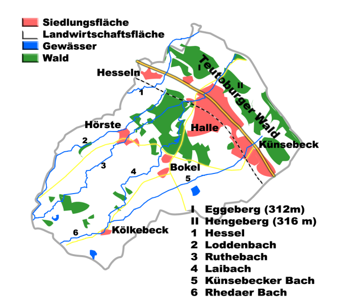
English: Land utilization in Halle (Westfalen), County of Gütersloh, Germany
Deutsch: Flächennutzung Halle (Westfalen), Kreis Gütersloh, Deutschland |
| Datum | |
| Bron | Eigen werk |
| Auteur | Hagar66 |
| Cameralocatie | | Deze en andere afbeeldingen in: OpenStreetMap |
|---|
_-_land_utilization.svg¶ms=052.060833_N_0008.359722_E_globe:Earth_type:camera__&language=nl)
Homemade maps cannot be 100% accurate. This is especially true for topographical data that is hard to incorporate 100% correctly in such maps. You are free to use the map as a starting point for your new improved versions.
Licentie
| Ik, de auteursrechthebbende van dit werk, geef dit werk vrij in het publieke domein. Dit is wereldwijd van toepassing. In sommige landen is dit wettelijk niet mogelijk; in die gevallen geldt: Ik sta iedereen toe dit werk voor eender welk doel te gebruiken, zonder enige voorwaarden, tenzij zulke voorwaarden door de wet worden voorgeschreven. |
Bestandsgeschiedenis
Klik op een datum/tijd om het bestand te zien zoals het destijds was.
| Datum/tijd | Miniatuur | Afmetingen | Gebruiker | Opmerking | |
|---|---|---|---|---|---|
| huidige versie | 26 apr 2009 22:32 | | 1.020 × 915 (541 kB) | Hagar66 | {{Information |Description= |Source= |Date= |Author= |Permission= |other_versions= }} |
| 31 dec 2008 21:47 |  | 902 × 832 (445 kB) | Hagar66 | {{Information |Description={{en|1=Land utilization in Halle (Westfalen), County of Gütersloh, Germany}} {{de|1=Flächennutzung Halle (Westfalen), Kreis Gütersloh, Deutschland}} |Source=Eigenes Werk (own work) |Author=Hagar66 |Date=31.12 |
Bestandsgebruik
Dit bestand wordt op de volgende pagina gebruikt:
Globaal bestandsgebruik
De volgende andere wiki's gebruiken dit bestand:
- Gebruikt op de.wikipedia.org
- Gebruikt op en.wikipedia.org
- Gebruikt op it.wikipedia.org
- Gebruikt op ja.wikipedia.org
_-_land_utilization.svg)