Bestand:Grand Staircase-big.jpg

Oorspronkelijk bestand (1.700 × 483 pixels, bestandsgrootte: 204 kB, MIME-type: image/jpeg)
| Dit is een bestand van Wikimedia Commons. Onderstaande beschrijving komt van de beschrijving van het bestand daar. |
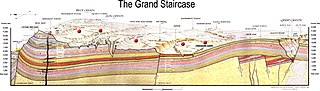
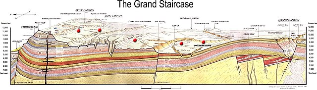
Beschrijving
NPS image from http://www.nps.gov/brca/geology_grand.html
(See: en:Aquarius Plateau)
Geology and Cross Section by Peter J. Coney / Revised; 1985. Artwork by Dick Beasley. Published by Zion Natural History Association, in Springdale. Original image is a scan of a separate map (41cm ×62cm, scale 1:435,000).
Depicts the Grand Canyon National Park, Cedar Breaks National Monument, Zion National Park
File modified from its original form.
Modifications
Cropped to remove detailed depictions of Bryce Canyon [and] Cedar Breaks Area, Zion Canyon Area, and Grand Canyon strata. Also cropped to remove quote:
- In this region the forces of erosion have laid bare over one billion fie undred million years of the Earth's history. The oldest rocks, those of the Archeozoic, Proterozoic and Paleozoic Eras are found in the walls of the Grand Canyon, where tracks of early amphibians and reptiles, primitive fish, trilobites, brachiopods and many other fossils have been discovered.
- The sheer walls, temples and towers of Zion Canyon are carved from rock layers of the Mesozoic Era. Other exposures of rocks of this era are along the Grey, White and Vermilion Cliffs. In these areas, the rocks contain bones and tracks of now-extinct dinosaurs as well as other reptiles, amphibians, ancient mammals and petrified wood.
- Younger rocks of the Cenozoic Era form the pinnacles of Cedar Breaks and Bryce Canyons. Presumably these layers as well as those of Mesozoic Age at Zion once extended over the Grand Canyon Region. However, the relentless wearing of the waters has since stripped these layers back to the north to for the celebrated "Great Rock Stairway" of the Vermilion, White, Gray and Pink Cliffs.
Other modifications include:
- Original title "Geologic Cross Section of the Cedar Breaks–Zion–Grand Canyon Region" blanked out and changed to "The Grand Staircase"
- In left & right margins, words "North" and "South" blanked out and both changed to "Elevation (feet)"
- Large red dots added near cliffs labels
- "Chocolate Cliffs" label added
Image labels
Strata
(given in stratigraphic order)
- V
- Brian Head [gray]
- Wasatch [light red, limestone]
- IV
- Kaiparowitz [lavender, sandstone]
- Straight Cliffs – Wahweap [gray, sandy siltstone]
- Coal [black]
- Tropic [gray, shale]
- Dakota [orange, sandstone]
- Carmel [lavender, sedimentary]
- Temple Cap [reddish white, crossbedding]
- Navajo [blended light red, crossbedding]
- Kayenta [lavender silty, sandstone]
- Moenave [dark orange, sandstone]
- Chinle [yellow, shale]
- Shinarump Member [tan, conglomerate]
- Moenkopi [dark red, shale]
- III
- Kaibab [tan, limestone]
- Toroweap [dark brown, limestone]
- Coconino [light tan, crossbedding]
- Hermit [light red, shale]
- Supai [light red, siltstone]
- Redwall [lavender, limestone]
- Temple Butte [purple, limestone]
- Muav [tan, limestone]
- Bright Angel [tan orange, shale]
- Tapeats [light brown, sandstone]
- II
- Dox [red orange, sandstone]
- Shinumo [orange tan, sandstone]
- Hakatai [deep red, shale]
- Diabase [light gray, intrusive igneous]
- Bass [white, limestone]
- I
- [Vishnu Group depicted (tan, foliated metamorphic)]
- [Zoroaster Granite depicted (white, granitic)]
Geography
(left to right)
- ↓ Cedar City 5800'
- I-15
- Coal Mines
- Hurricane Cliffs
- ↓ Cedar Breaks 10,350'
- ↓ Brian Head 11,307'
- Lava Flow
- ↓ Markagunt Plateau
- Panguitch Lake
- ← Navajo Lake
- Lava
- ← Red Canyon
- Long Valley Jct.
- ↓ Paunsaugunt Plateau
- Pink Cliffs
- ↓ Bryce Canyon 8500'
- ← Tropic
- ↓ Aquarius Plateau
- Grey Cliffs
- Sevier Fault ↓
- Sunset Cliffs
- Table Cliffs
- West Temple 7795' →
- Kolob Terrace
- ↓ Zion Canyon 4000'
- Mt. Carmel Junction
- White Cliffs
- Sevier Fault ↓
- ↓ Coral Pink Sand Dunes
- ↓ Pipe Spring 5000'
- ↓ Kanab
- Vermilion Cliffs
- Antelope Valley
- Fredonia
- U.S. 89
- U.S. 89 A
- ↓ Kaiparowits Plateau
- Paria River
- Chocolate Cliffs
- ↓ Colorado River
- Rainbow Bridge ↓
- ↓ Lake Powell
- ↓ Navajo Mountain 10,388'
- Glen Canyon Dam
- Page
- Echo Cliffs
- ↓ Jacob Lake
- Black Mesa →
- ↓ Kaibab Plateau
- Painted Desert
- ↓ North Rim 8000'
- ↓ Grand Canyon
- Cape Royal ←
- ↓ South Rim 7000'
Faults
(left to right)
- Hurricane Fault
- Sevier Fault
Licentie
| Dit beeld- of mediabestand bevat materiaal gebaseerd op een werk van een National Park Service medewerker, gemaakt als onderdeel van de officiële taken van die persoon. Als een werk van de Amerikaanse federale overheid, bevindt dergelijk werk zich in het publieke domein in de Verenigde Staten. Zie de NPS website en NPS copyright policy voor meer informatie. |
Bestandsgeschiedenis
Klik op een datum/tijd om het bestand te zien zoals het destijds was.
| Datum/tijd | Miniatuur | Afmetingen | Gebruiker | Opmerking | |
|---|---|---|---|---|---|
| huidige versie | 8 sep 2005 07:20 | 1.700 × 483 (204 kB) | Huebi~commonswiki | NPS image from [http://www.nps.gov/brca/geology_grand.html] {{PD-USGov-NPS}} category:US National Parks |
Bestandsgebruik
Dit bestand wordt op de volgende 3 pagina's gebruikt:
Globaal bestandsgebruik
De volgende andere wiki's gebruiken dit bestand:
- Gebruikt op ca.wikipedia.org
- Gebruikt op de.wikipedia.org
- Gebruikt op en.wikipedia.org
- Gebruikt op es.wikipedia.org
- Gebruikt op fr.wikipedia.org
- Gebruikt op he.wikipedia.org
- Gebruikt op hu.wikipedia.org
- Gebruikt op it.wikipedia.org
- Gebruikt op ja.wikipedia.org
- Gebruikt op no.wikipedia.org
- Gebruikt op pl.wikipedia.org
- Gebruikt op tr.wikipedia.org