Bestand:Golan heights rel89-orig.jpg

Grootte van deze voorvertoning: 474 × 599 pixels. Andere resoluties: 190 × 240 pixels | 380 × 480 pixels | 974 × 1.231 pixels.
Oorspronkelijk bestand (974 × 1.231 pixels, bestandsgrootte: 245 kB, MIME-type: image/jpeg)
| Dit is een bestand van Wikimedia Commons. Onderstaande beschrijving komt van de beschrijving van het bestand daar. |
| Beschrijving |
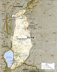
English: CIA map of the Golan Heights showing Israeli settlements and Syrian villages as of 1989 |
|||
| Datum | ||||
| Bron | http://www.lib.utexas.edu/maps/middle_east_and_asia/golan_heights_rel89.jpg | |||
| Auteur | CIA | |||
| Toestemming (Hergebruik van dit bestand) |
|

Bestandsgeschiedenis
Klik op een datum/tijd om het bestand te zien zoals het destijds was.
| Datum/tijd | Miniatuur | Afmetingen | Gebruiker | Opmerking | |
|---|---|---|---|---|---|
| huidige versie | 7 jul 2009 17:15 | | 974 × 1.231 (245 kB) | Nableezy | {{Information |Description={{en|1=CIA map of the Golan Height showing Israeli settlements and Syrian villages as of 1989}} |Source=http://www.lib.utexas.edu/maps/middle_east_and_asia/golan_heights_rel89.jpg |Author=CIA |Date=1989 |Permission={{PD-USGov-CI |
Bestandsgebruik
Dit bestand wordt op de volgende 2 pagina's gebruikt:
Globaal bestandsgebruik
De volgende andere wiki's gebruiken dit bestand:
- Gebruikt op ar.wikipedia.org
- Gebruikt op arz.wikipedia.org
- Gebruikt op be-tarask.wikipedia.org
- Gebruikt op bg.wikipedia.org
- Gebruikt op ca.wikipedia.org
- Gebruikt op csb.wikipedia.org
- Gebruikt op cs.wikipedia.org
- Gebruikt op da.wikipedia.org
- Gebruikt op en.wikipedia.org
- Gebruikt op es.wikipedia.org
- Gebruikt op fy.wikipedia.org
- Gebruikt op hi.wikipedia.org
- Gebruikt op hy.wikipedia.org
- Gebruikt op id.wikipedia.org
- Gebruikt op incubator.wikimedia.org
- Gebruikt op it.wikipedia.org
- Gebruikt op ka.wikipedia.org
- Gebruikt op lt.wikipedia.org
- Gebruikt op ms.wikipedia.org
- Gebruikt op nn.wikipedia.org
- Gebruikt op no.wikipedia.org
- Gebruikt op pl.wikipedia.org
- Gebruikt op pnb.wikipedia.org
- Gebruikt op pt.wikibooks.org
- Gebruikt op ru.wikipedia.org
- Gebruikt op uk.wikipedia.org
- Gebruikt op vi.wikipedia.org
- Gebruikt op www.wikidata.org
- Gebruikt op xmf.wikipedia.org
- Gebruikt op zh.wikipedia.org