Bestand:German Empire states map.svg

Afmetingen van deze voorvertoning van het type PNG van dit SVG-bestand: 496 × 600 pixels Andere resoluties: 198 × 240 pixels | 397 × 480 pixels | 635 × 768 pixels | 847 × 1.024 pixels | 1.694 × 2.048 pixels | 1.042 × 1.260 pixels.
Oorspronkelijk bestand (SVG-bestand, nominaal 1.042 × 1.260 pixels, bestandsgrootte: 2,31 MB)
| Dit is een bestand van Wikimedia Commons. Onderstaande beschrijving komt van de beschrijving van het bestand daar. |
Beschrijving
| Beschrijving |
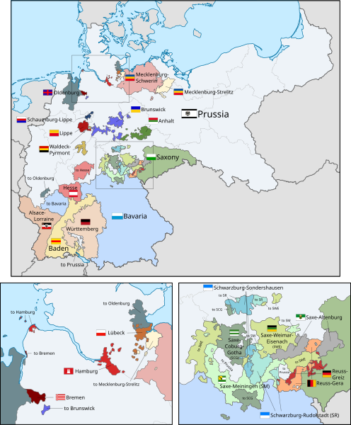
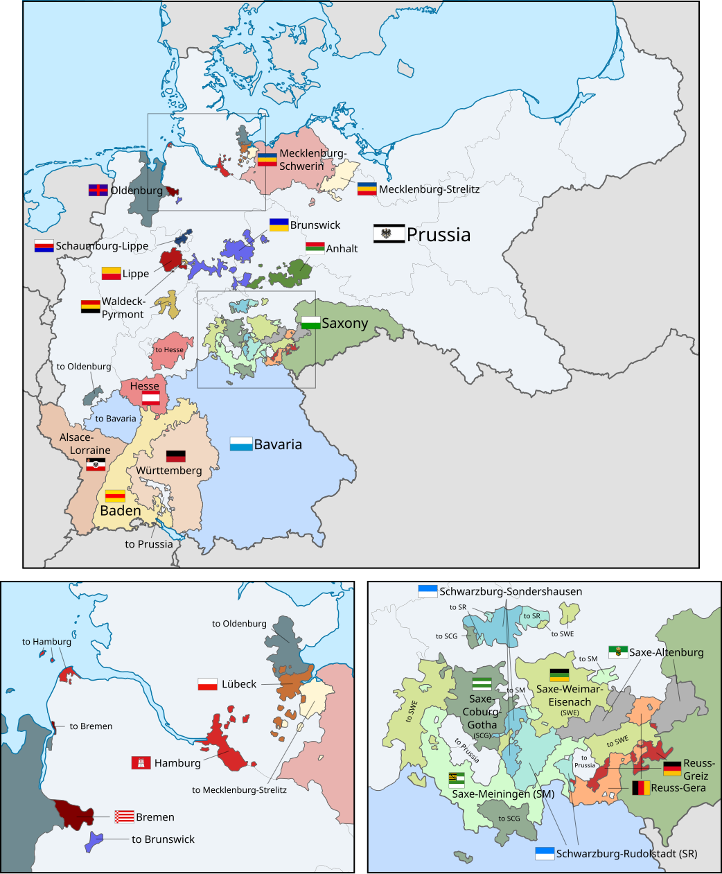
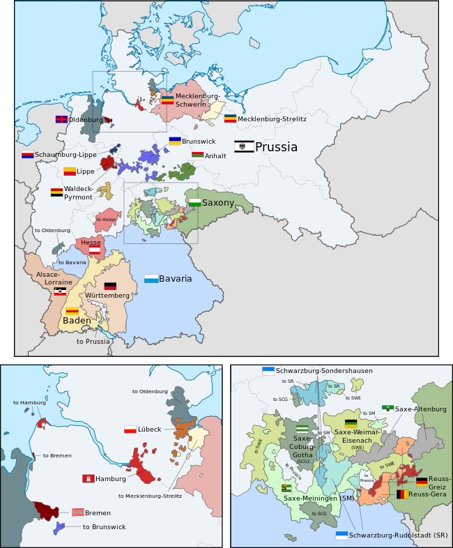
English: A map of the states of the German Empire, showing their location, flags and names in English. |
| Datum | |
| Bron |
Dit bestand is afgeleid van: German Empire blank map.svg: Deze vectorafbeelding bevat onderdelen die afkomstig zijn uit van: Deze vectorafbeelding bevat onderdelen die afkomstig zijn uit van: Deze vectorafbeelding bevat onderdelen die afkomstig zijn uit van: Deze vectorafbeelding bevat onderdelen die afkomstig zijn uit van: Deze vectorafbeelding bevat onderdelen die afkomstig zijn uit van: Deze vectorafbeelding bevat onderdelen die afkomstig zijn uit van: Deze vectorafbeelding bevat onderdelen die afkomstig zijn uit van: Deze vectorafbeelding bevat onderdelen die afkomstig zijn uit van: Deze vectorafbeelding bevat onderdelen die afkomstig zijn uit van: Deze vectorafbeelding bevat onderdelen die afkomstig zijn uit van: Deze vectorafbeelding bevat onderdelen die afkomstig zijn uit van: Deze vectorafbeelding bevat onderdelen die afkomstig zijn uit van: Deze vectorafbeelding bevat onderdelen die afkomstig zijn uit van: Deze vectorafbeelding bevat onderdelen die afkomstig zijn uit van: Deze vectorafbeelding bevat onderdelen die afkomstig zijn uit van: Deze vectorafbeelding bevat onderdelen die afkomstig zijn uit van: Deze vectorafbeelding bevat onderdelen die afkomstig zijn uit van: Deze vectorafbeelding bevat onderdelen die afkomstig zijn uit van: Deze vectorafbeelding bevat onderdelen die afkomstig zijn uit van: Deze vectorafbeelding bevat onderdelen die afkomstig zijn uit van: Deze vectorafbeelding bevat onderdelen die afkomstig zijn uit van: Deze vectorafbeelding bevat onderdelen die afkomstig zijn uit van: |
| Auteur |
|
| Andere versies |
|
| SVG ontwikkeling | De broncode van dit SVG-bestand is deugdelijk. Deze vlag is gemaakt met een onbekende SVG-editor This flag uses embedded text that can be easily translated using a text editor. |


.svg)
.svg)
.svg)
.svg)
.svg)
.svg)
Licentie
Ik, de auteursrechthebbende van dit werk, maak het hierbij onder de volgende licentie beschikbaar:
Dit bestand is gelicenseerd onder de Creative Commons-licentie Naamsvermelding-Gelijk delen 3.0 Unported
- De gebruiker mag:
- Delen – het werk kopiëren, verspreiden en doorgeven
- Remixen – afgeleide werken maken
- Onder de volgende voorwaarden:
- naamsvermelding – U moet op een gepaste manier aan naamsvermelding doen, een link naar de licentie geven, en aangeven of er wijzigingen in het werk zijn aangebracht. U mag dit op elke redelijke manier doen, maar niet zodanig dat de indruk wordt gewekt dat de licentiegever instemt met uw werk of uw gebruik van zijn werk.
- Gelijk delen – Als u het werk heeft geremixt, veranderd, of erop heeft voortgebouwd, moet u het gewijzigde materiaal verspreiden onder dezelfde licentie als het oorspronkelijke werk, of een daarmee compatibele licentie.
Code for clickable map
Bestandsgeschiedenis
Klik op een datum/tijd om het bestand te zien zoals het destijds was.
| Datum/tijd | Miniatuur | Afmetingen | Gebruiker | Opmerking | |
|---|---|---|---|---|---|
| huidige versie | 24 feb 2019 04:43 | | 1.042 × 1.260 (2,31 MB) | Alphathon | Corrected Brunswick territory accidentally given to Anhalt |
| 4 nov 2015 16:55 |  | 1.042 × 1.260 (2,39 MB) | Alphathon | Slight optimisation | |
| 4 nov 2015 03:33 |  | 1.042 × 1.260 (2,39 MB) | Alphathon | Another minor tweak | |
| 4 nov 2015 03:31 |  | 1.042 × 1.260 (2,39 MB) | Alphathon | Tweaked colours | |
| 4 nov 2015 00:25 |  | 1.042 × 1.260 (2,39 MB) | Alphathon | Corrected typo | |
| 3 nov 2015 13:51 |  | 1.042 × 1.260 (2,39 MB) | Alphathon | {{Information |Description={{en|A map of the states of the en:German Empire, showing their location, flags and names in English.}} |Source={{Derived from|File:German Empire blank map.svg|display=50}} {{AttribSVG|Flagge Herzogtum Anhalt.svg|David... |
Bestandsgebruik
Dit bestand wordt op de volgende 2 pagina's gebruikt:
Globaal bestandsgebruik
De volgende andere wiki's gebruiken dit bestand:
- Gebruikt op ar.wikipedia.org
- Gebruikt op ast.wikipedia.org
- Gebruikt op az.wikipedia.org
- Gebruikt op ca.wikipedia.org
- Gebruikt op en.wikipedia.org
- Gebruikt op es.wikipedia.org
- Gebruikt op fi.wikipedia.org
- Gebruikt op he.wikipedia.org
- Gebruikt op hu.wikipedia.org
- Gebruikt op it.wikipedia.org
- Gebruikt op pt.wikipedia.org
- Gebruikt op sr.wikipedia.org
- Gebruikt op th.wikipedia.org
- Gebruikt op zh.wikipedia.org