Bestand:FraMauro1420Ship.png

Oorspronkelijk bestand (1.286 × 768 pixels, bestandsgrootte: 2,12 MB, MIME-type: image/png)
| Dit is een bestand van Wikimedia Commons. Onderstaande beschrijving komt van de beschrijving van het bestand daar. |
Beschrijving
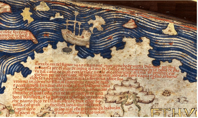
Portion of the Fra Mauro World Map (1450). Source: Piero Falchetta "Fra Mauro's World Map".
Text (Italian) [1] (10, A 13):
- "Circa hi ani del Signor 1420 una naue ouer çoncho de india discorse per una trauersa per el mar de india a la uia de le isole de hi homeni e de le done de fuora dal cauo de diab e tra le isole uerde e le oscuritade a la uia de ponente e de garbin per 40 çornade, non trouando mai altro che aiere e aqua, e per suo arbitrio iscorse 2000 mia e declinata la fortuna i fece suo retorno in çorni 70 fina al sopradito cauo de diab. E acostandose la naue a le riue per suo bisogno, i marinari ubitch uno ouo de uno oselo nominato chrocho, el qual ouo era de la grandeça de una bota d'anfora, e la grandeça de l'oselo era tanta che da uno piço de l'ala a l'altro se dice esser 60 passa, e con gran facillità lieua uno elefante e ogni altro grando animal e fa gran dano a li habitanti del paexe et è uelocissimo nel suo uolar".
Henry Davis gives this translation on his maps website archief kopie op de Wayback Machine:
- "About the year of Our Lord 1420 a ship, what is called an Indian junk [Zoncho de India], on a crossing of the Sea of India towards the Isle of Men and Women, was driven by a storm beyond the Cape of Diab, through the Green Isles, out into the Sea of Darkness on their way west and southwest. Nothing but air and water was seen for forty days and by their reckoning they ran 2,000 miles and fortune deserted them. When the stress of the weather had subsided they made the return to the said Cavo de Diab in seventy days and drawing near to the shore to supply their wants the sailors saw the egg of a bird called roc, the egg being as big as a seven gallon cask, and the size of the bird is such that from the point of one wing to another was sixty paces and it can quite easily lift an elephant or any other large animal. It does great damage to the inhabitants and is very fast in its flight".
Fra Mauro map has a label "Diab" on a region of South Africa which is either the Cape Peninsula or Madagascar.
"Isle of Men and Women" or "Male and Female Islands" (Imangla and Inebila) are two semi-mythical islands described by many early Arab travel narratives. Marco Polo places them in the Arabian Sea some 500 miles south of Makran (now a coastal region in Pakistan) in the neighborhood of Socotra. Fra Mauro places them south of Zanzibar. Other early travelers and cartographers proposed locations in Southeast Asia, as far east as Singapore. (Early mapping of Southeast Asia, Thomas Suárez, 1999)
"Green Isles" is an old term for Cape Verde.
The fragment discussing the 'roc' is possibly an exaggerated reference to extinct "elephant birds", which lived on Madagascar until some time before the 17th century.
Licentie
|
Dit werk bevindt zich in het publiek domein in landen en gebieden waar de auteursrechttermijn het leven van de auteur plus 70 jaar of minder is.
| |
| Van dit bestand is vastgesteld dat er geen bekende auteursrechtaanspraken op rusten, alle aanverwante en naburige rechten daarbij inbegrepen. | |
Bestandsgeschiedenis
Klik op een datum/tijd om het bestand te zien zoals het destijds was.
| Datum/tijd | Miniatuur | Afmetingen | Gebruiker | Opmerking | |
|---|---|---|---|---|---|
| huidige versie | 24 apr 2007 22:12 | | 1.286 × 768 (2,12 MB) | World Imaging | Portion of the Fra Mauro World Map (1450). Source: Piero Falchetta "Fra Mauro's World Map". |
Bestandsgebruik
Dit bestand wordt op de volgende pagina gebruikt:
Globaal bestandsgebruik
De volgende andere wiki's gebruiken dit bestand:
- Gebruikt op ar.wikipedia.org
- Gebruikt op cs.wikipedia.org
- Gebruikt op en.wikipedia.org
- Gebruikt op en.wikiquote.org
- Gebruikt op eo.wikipedia.org
- Gebruikt op es.wikipedia.org
- Gebruikt op he.wikipedia.org
- Gebruikt op ja.wikipedia.org
- Gebruikt op ml.wikipedia.org
- Gebruikt op my.wikipedia.org
- Gebruikt op pt.wikipedia.org
- Gebruikt op ru.wikipedia.org
- Gebruikt op sl.wikipedia.org
- Gebruikt op tr.wikipedia.org
- Gebruikt op uk.wikipedia.org
- Gebruikt op zh.wikipedia.org