Bestand:Flag of Bosnia and Herzegovina (construction sheet).svg

Oorspronkelijk bestand (SVG-bestand, nominaal 1.290 × 690 pixels, bestandsgrootte: 16 kB)
| Dit is een bestand van Wikimedia Commons. Onderstaande beschrijving komt van de beschrijving van het bestand daar. |
.svg)
Beschrijving
| Beschrijving |
English: Flag of Bosnia and Herzegovina — construction sheet |
| Datum | |
| Bron |
Eigen werk. This construction sheet is derived from multiple sources:
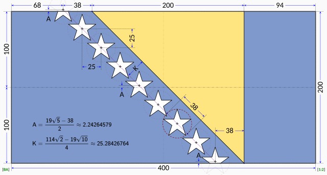
The specification drawing provides:
The triangle is isosceles with one edge running at 45° relative to the edges of the flag. According to the law, the stars are supposed to parallel to the triangle's edge, so it stands that the line of stars must run in a precise 45° line. The law does not explicitly dictate the precise placement of the stars. Close examination of the government EPS drawing reveals most of the intended geometry:
The only missing information is the precise horizontal positioning of the line of stars. Based on measurements from the government EPS drawing, the vertical centerline of the centre star is located at distance from the hoist that is roughly 42.4% of the length of the flag. The centre star was chosen for the measurement because the line of stars in the EPS drawing runs at about 45.5° instead of the 45° dictated by the law. The same measurement repeated on the specification drawing reveals a distance of about 41.8% of the length of the flag with the line of stars again at 45.5°. For the purpose of this Wikimedia construction sheet, the distance from the hoist to the vertical centerline of the centre star is assumed to be exactly 42.0% of the length of the flag. All the other stars are laid out with equal spacing on a precise 45° degree line. Vertical coordinates of the stars are controlled by the intersections of the top and bottom stars with the flag edges. |
| Auteur | MapGrid |
Licentie

|
Deze afbeelding toont een vlag, een wapen, een zegel of een ander officieel insigne. Voor het gebruik van dergelijke symbolen bestaan in veel landen wettelijke beperkingen. Deze beperkingen staan los van de auteursrechtelijke status. |
| Ik, de auteursrechthebbende van dit werk, geef dit werk vrij in het publieke domein. Dit is wereldwijd van toepassing. In sommige landen is dit wettelijk niet mogelijk; in die gevallen geldt: Ik sta iedereen toe dit werk voor eender welk doel te gebruiken, zonder enige voorwaarden, tenzij zulke voorwaarden door de wet worden voorgeschreven. |
Bestandsgeschiedenis
Klik op een datum/tijd om het bestand te zien zoals het destijds was.
| Datum/tijd | Miniatuur | Afmetingen | Gebruiker | Opmerking | |
|---|---|---|---|---|---|
| huidige versie | 17 jan 2023 15:58 | | 1.290 × 690 (16 kB) | MapGrid | Reverted to version as of 13:48, 17 January 2023 (UTC) |
| 17 jan 2023 15:51 |  | 1.290 × 690 (16 kB) | MapGrid | ... slightly darker vertical centerline. | |
| 17 jan 2023 15:48 |  | 1.290 × 690 (16 kB) | MapGrid | Added an opaque background. Added vertical centerline. No change to flag geometry. | |
| 23 jan 2022 18:00 |  | 1.290 × 690 (16 kB) | MapGrid | Uploaded own work with UploadWizard |
Bestandsgebruik
Dit bestand wordt op de volgende pagina gebruikt:
Globaal bestandsgebruik
De volgende andere wiki's gebruiken dit bestand:
- Gebruikt op af.wikipedia.org
- Gebruikt op cs.wikipedia.org
- Gebruikt op en.wikipedia.org
- Gebruikt op hr.wikipedia.org
- Gebruikt op uk.wikipedia.org
- Gebruikt op zh.wikipedia.org
.svg)