Bestand:FederationOfSouthArabiaMap.jpg
Grootte van deze voorvertoning: 800 × 506 pixels. Andere resoluties: 320 × 202 pixels | 640 × 405 pixels | 1.024 × 648 pixels | 1.280 × 809 pixels | 2.282 × 1.443 pixels.
Oorspronkelijk bestand (2.282 × 1.443 pixels, bestandsgrootte: 361 kB, MIME-type: image/jpeg)
| Dit is een bestand van Wikimedia Commons. Onderstaande beschrijving komt van de beschrijving van het bestand daar. |
Beschrijving

|
Bestand:Federation of South Arabia constituents map - ru.svg is een vectorversie van dit bestand. Indien niet van slechtere kwaliteit dient deze gebruikt te worden in plaats van deze rasterafbeelding.
File:FederationOfSouthArabiaMap.jpg → File:Federation of South Arabia constituents map - ru.svg
Zie Help:SVG voor meer informatie. |
 |
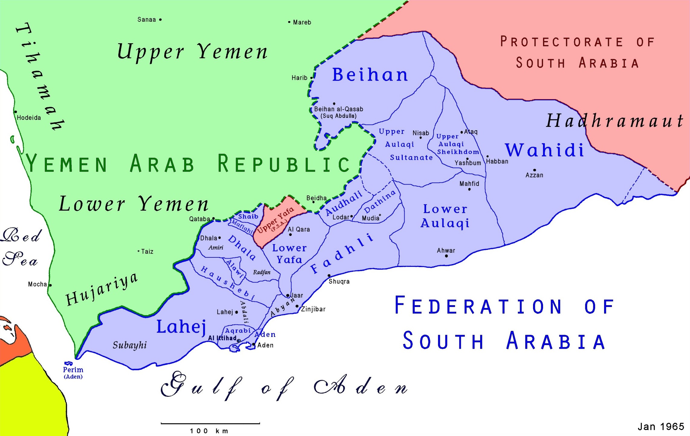
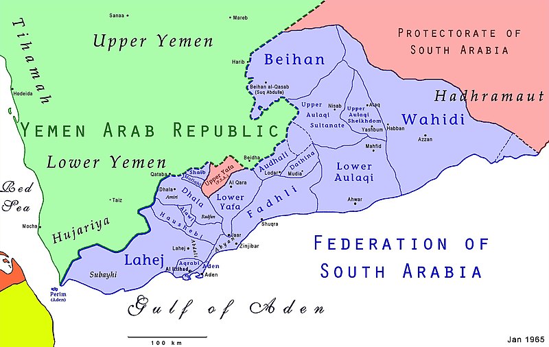
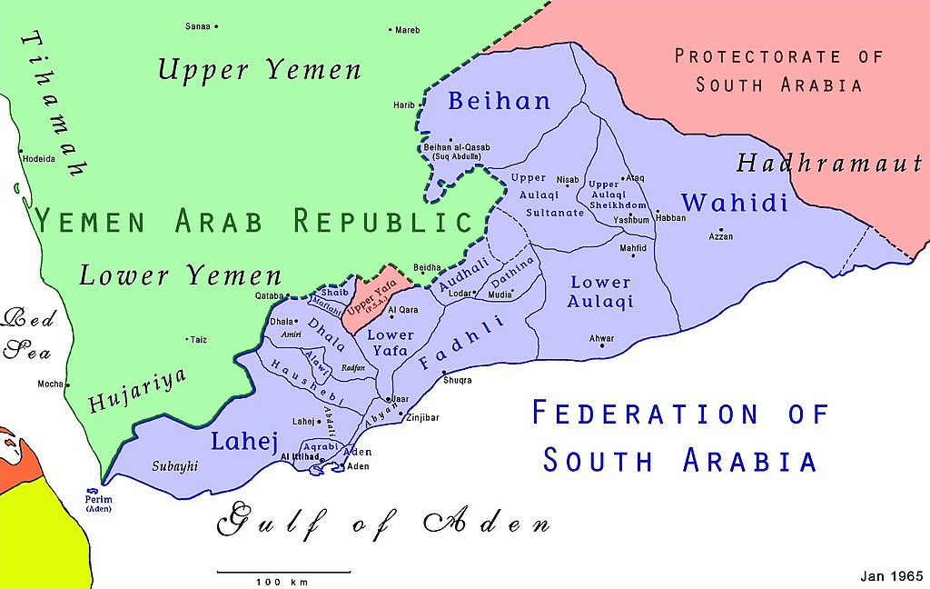
Map of the Federation of South Arabia in present-day Yemen. Uploader is author; based on US Dept of the Army information
Licentie

|
De auteursrechthebbende van deze afbeelding geeft hierbij onherroepelijk alle rechten erop vrij, waardoor deze vrijelijk kan worden gereproduceerd, gedistribueerd, verzonden, gebruikt, gewijzigd, voortgebouwd op of anderszins geëxploiteerd op welke manier dan ook door wie dan ook voor welk doel dan ook, commercieel of niet-commercieel. Uit beleefdheid zou een link terug naar Wikipedia (http://www.wikipedia.org/) echter op prijs worden gesteld.
|
Dit werk bevindt zich in het publieke domein in de Verenigde Staten omdat het is vervaardigd door een ambtenaar van de Amerikaanse federale overheid tijdens de uitoefening van zijn functie, en het daarmee volgens Titel 17, Hoofdstuk 1, Sectie 105 van de United States Code [Engelstalige link] een werk van de Amerikaanse federale overheid [Engelstalige link] is.
Nota bene: Het bovenstaande is alleen van toepassing op werken van de federale overheid of een van haar onderdelen, en niet op werken van een afzonderlijk(e) Staat, Territorium, Commonwealth, County, Gemeente, of enig andere bestuurlijke eenheid. Dit sjabloon is ook niet van toepassing op ontwerpen voor postzegels, door de United States Postal Service openbaar gemaakt sinds 1978 [Engelstalige link]. Zie Art. 206.02(b) van "Compendium II: Copyright Office Practices" (Engelstalig).
|
 | |
| Van dit bestand is vastgesteld dat er geen bekende auteursrechtaanspraken op rusten, alle aanverwante en naburige rechten daarbij inbegrepen. | ||
Bestandsgeschiedenis
Klik op een datum/tijd om het bestand te zien zoals het destijds was.
| Datum/tijd | Miniatuur | Afmetingen | Gebruiker | Opmerking | |
|---|---|---|---|---|---|
| huidige versie | 1 aug 2021 00:39 | | 2.282 × 1.443 (361 kB) | AjaxSmack | Reverted to version as of 02:00, 18 January 2010 (UTC) |
| 25 jul 2019 11:09 |  | 2.600 × 2.245 (584 kB) | Havsjö | clearer | |
| 18 jan 2010 04:00 |  | 2.282 × 1.443 (361 kB) | Anonimosanhueza | borders removed | |
| 18 dec 2006 00:56 |  | 2.297 × 1.459 (413 kB) | Electionworld | {{ew|en|AjaxSmack}} == Summary == Map of the {{link|Federation of South Arabia}} in present-day {{link|Yemen}}. Uploader is author; based on US Dept of the Army information {{CopyrightedFreeUse-Link}} == Licensing == {{PD-USGov}} |
Bestandsgebruik
Dit bestand wordt op de volgende 6 pagina's gebruikt:
Globaal bestandsgebruik
De volgende andere wiki's gebruiken dit bestand:
- Gebruikt op ar.wikipedia.org
- Gebruikt op azb.wikipedia.org
- Gebruikt op be.wikipedia.org
- Gebruikt op bn.wikipedia.org
- Gebruikt op ca.wikipedia.org
- Gebruikt op cs.wikipedia.org
- Gebruikt op de.wikipedia.org
- Gebruikt op en.wikipedia.org
Globaal gebruik van dit bestand bekijken.