Bestand:Farquhar atoll.jpg
Geen hogere resolutie beschikbaar.
Farquhar_atoll.jpg (407 × 431 pixels, bestandsgrootte: 38 kB, MIME-type: image/jpeg)
| Dit is een bestand van Wikimedia Commons. Onderstaande beschrijving komt van de beschrijving van het bestand daar. |
Beschrijving
| Beschrijving |
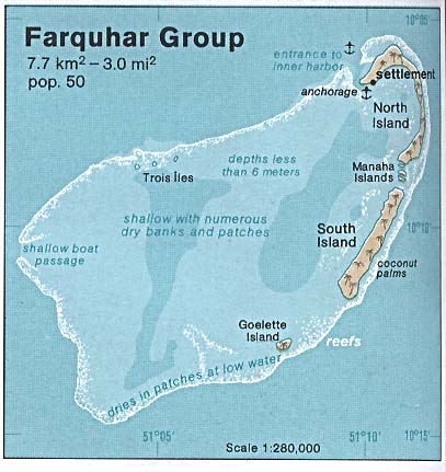
Deutsch: Karte des Farquhar-Atolls, Seychellen
English: Map of Farquhar Atoll, Outer Islands of Seychelles
Español: Mapa de Farquhar (Atolón de Farquhar), Archipiélago de Seychelles |
| Datum | |
| Bron | http://www.lib.utexas.edu/maps/islands_oceans_poles/farquhar_group_76.jpg |
| Auteur | Taken from Perry-Castañeda Library (PCL), originally from CIA Indian Ocean Atlas |
| Toestemming (Hergebruik van dit bestand) |
PD, see licensing |
Licentie
| This image is a work of a Central Intelligence Agency employee, taken or made as part of that person's official duties. As a Work of the United States Government, this image or media is in the public domain in the United States.
|

|
Oorspronkelijk uploadlogboek
Original Uploader was SDC (talk) at 3 July 2005.
- 15:09, 3 July 2005 . . SDC (Talk | contribs) . . 407×431 (38,797 bytes) (CIA Public Domain)
Bestandsgeschiedenis
Klik op een datum/tijd om het bestand te zien zoals het destijds was.
| Datum/tijd | Miniatuur | Afmetingen | Gebruiker | Opmerking | |
|---|---|---|---|---|---|
| huidige versie | 25 mei 2007 14:04 | | 407 × 431 (38 kB) | Telim tor | == Information == {{Information |Description=Map of Farquhar Atoll, Seychelles |Source=http://www.lib.utexas.edu/maps/islands_oceans_poles/farquhar_group_76.jpg |Date=1976 |Author=Taken from Perry-Castañeda Library (PCL), originally from CIA Indian Ocean |
Bestandsgebruik
Dit bestand wordt op de volgende 2 pagina's gebruikt:
Globaal bestandsgebruik
De volgende andere wiki's gebruiken dit bestand:
- Gebruikt op ca.wikipedia.org
- Gebruikt op de.wikipedia.org
- Gebruikt op en.wikipedia.org
- Gebruikt op fr.wikipedia.org
- Gebruikt op gl.wikipedia.org
- Gebruikt op hy.wikipedia.org
- Gebruikt op ka.wikipedia.org
- Gebruikt op no.wikipedia.org
- Gebruikt op pl.wikipedia.org
- Gebruikt op pt.wikipedia.org
- Gebruikt op ru.wikipedia.org
- Gebruikt op uk.wikipedia.org
- Gebruikt op zh.wikipedia.org