Bestand:Fangataufa.JPG

Grootte van deze voorvertoning: 600 × 600 pixels. Andere resoluties: 240 × 240 pixels | 480 × 480 pixels | 768 × 768 pixels | 1.024 × 1.024 pixels | 2.000 × 2.000 pixels.
Oorspronkelijk bestand (2.000 × 2.000 pixels, bestandsgrootte: 402 kB, MIME-type: image/jpeg)
| Dit is een bestand van Wikimedia Commons. Onderstaande beschrijving komt van de beschrijving van het bestand daar. |
Beschrijving
| Beschrijving |
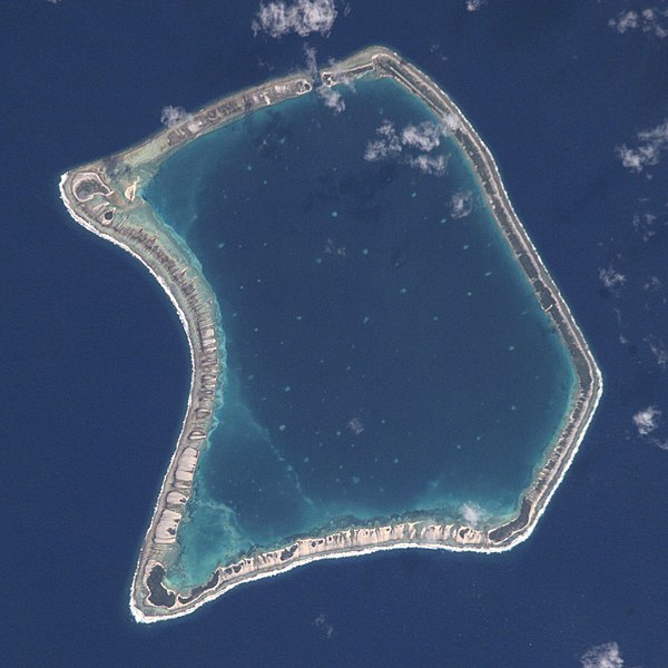
English: NASA Astronaut Image of Fangataufa Atoll (Tuamotu Archipelago, French Polynesia) in the Pacific Ocean
Русский: Космический снимок НАСА атолла Фангатауфа (архипелаг Туамоту, Французская Полинезия) в Тихом океане |
| Datum | |
| Bron | http://nix.larc.nasa.gov/info;jsessionid=1ci2vn53647eg?id=ISS002-E-7354&orgid=3 |
| Auteur | NASA Johnson Space Center - Earth Sciences and Image Analysis |
| Cameralocatie | | Deze en andere afbeeldingen in: OpenStreetMap |
|---|
Deze afbeelding of video is gecatalogiseerd door Johnson Space Center van de Verenigde Staten National Aeronautics and Space Administration (NASA)onder Foto ID: ISS002-E-7354.Deze banner zegt niets over de auteursrechten die van toepassing zijn. Een normale auteursrechten-tag is nodig. Zie Commons:Licensing voor meer informatie. Andere talen:
|
Licentie
This file is in the public domain in the United States because it was created by the Image Science & Analysis Laboratory, of the NASA Johnson Space Center. NASA copyright policy states that "NASA material is not protected by copyright unless noted". (NASA media use guidelines or Conditions of Use of Astronaut Photographs).
Photo source: ISS002-E-7354.
|

|
Deze afbeelding is beoordeeld op basis van de criteria voor waardevolle afbeeldingen en wordt beschouwd als de meest waardevolle afbeelding op Commons binnen het onderwerpgebied: Fangataufa atoll, French Polynesia - satellite view. Deze nominatie kan bekeken worden op Commons:Valued image candidates/Fangataufa.JPG. |
Bestandsgeschiedenis
Klik op een datum/tijd om het bestand te zien zoals het destijds was.
| Datum/tijd | Miniatuur | Afmetingen | Gebruiker | Opmerking | |
|---|---|---|---|---|---|
| huidige versie | 29 jun 2017 21:06 | | 2.000 × 2.000 (402 kB) | Szczureq | full resolution |
| 11 apr 2008 17:26 |  | 418 × 433 (53 kB) | Vriullop | cropped and rotated with north on top | |
| 15 okt 2007 20:35 |  | 640 × 437 (49 kB) | Переход Артур | {{Information |Description=TUAMOTU ARCHIPELAGO/FANGATAUFA ATOLL |Source= |Date=06.15.2001 |Author=NASA Johnson Space Center - Earth Sciences and Image Analysis |Permission= |other_versions= }} Category:Tuamotu |
Bestandsgebruik
Dit bestand wordt op de volgende 2 pagina's gebruikt:
Globaal bestandsgebruik
De volgende andere wiki's gebruiken dit bestand:
- Gebruikt op ast.wikipedia.org
- Gebruikt op bg.wikipedia.org
- Gebruikt op br.wikipedia.org
- Gebruikt op ca.wikipedia.org
- Gebruikt op ceb.wikipedia.org
- Gebruikt op cs.wikipedia.org
- Gebruikt op de.wikipedia.org
- Gebruikt op en.wikipedia.org
- Gebruikt op es.wikipedia.org
- Gebruikt op eu.wikipedia.org
- Gebruikt op fi.wikipedia.org
- Gebruikt op frr.wikipedia.org
- Gebruikt op fr.wikipedia.org
- Gebruikt op gl.wikipedia.org
- Gebruikt op id.wikipedia.org
- Gebruikt op it.wikipedia.org
- Gebruikt op ja.wikipedia.org
- Gebruikt op ko.wikipedia.org
- Gebruikt op lt.wikipedia.org
- Gebruikt op no.wikipedia.org
- Gebruikt op pap.wikipedia.org
- Gebruikt op pl.wikipedia.org
- Gebruikt op pl.wiktionary.org
- Gebruikt op pt.wikipedia.org
- Gebruikt op ru.wikipedia.org
- Gebruikt op simple.wikipedia.org
- Gebruikt op sk.wikipedia.org
- Gebruikt op sv.wikipedia.org
- Gebruikt op sv.wiktionary.org
- Gebruikt op sw.wikipedia.org
- Gebruikt op uk.wikipedia.org
- Gebruikt op www.wikidata.org
- Gebruikt op zh.wikipedia.org