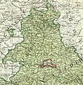
Bestand:Fürstentum Regensburg 1807.jpg

Grootte van deze voorvertoning: 591 × 599 pixels. Andere resoluties: 237 × 240 pixels | 473 × 480 pixels | 792 × 803 pixels.
Oorspronkelijk bestand (792 × 803 pixels, bestandsgrootte: 509 kB, MIME-type: image/jpeg)
Bestandsgeschiedenis
Klik op een datum/tijd om het bestand te zien zoals het destijds was.
| Datum/tijd | Miniatuur | Afmetingen | Gebruiker | Opmerking | |
|---|---|---|---|---|---|
| huidige versie | 27 mei 2015 03:34 |  | 792 × 803 (509 kB) | Lubiesque | User created page with UploadWizard |
Bestandsgebruik
Dit bestand wordt op de volgende pagina gebruikt:
Globaal bestandsgebruik
De volgende andere wiki's gebruiken dit bestand:
- Gebruikt op br.wikipedia.org
- Gebruikt op cs.wikipedia.org
- Gebruikt op de.wikipedia.org
- Gebruikt op en.wikipedia.org
- Gebruikt op es.wikipedia.org
- Gebruikt op fi.wikipedia.org
- Gebruikt op fr.wikipedia.org
- Gebruikt op it.wikipedia.org
- Gebruikt op ja.wikipedia.org
- Gebruikt op mk.wikipedia.org
- Gebruikt op vi.wikipedia.org
- Gebruikt op zh.wikipedia.org