Bestand:Europe 1914.png

Oorspronkelijk bestand (1.194 × 859 pixels, bestandsgrootte: 287 kB, MIME-type: image/png)
| Dit is een bestand van Wikimedia Commons. Onderstaande beschrijving komt van de beschrijving van het bestand daar. |

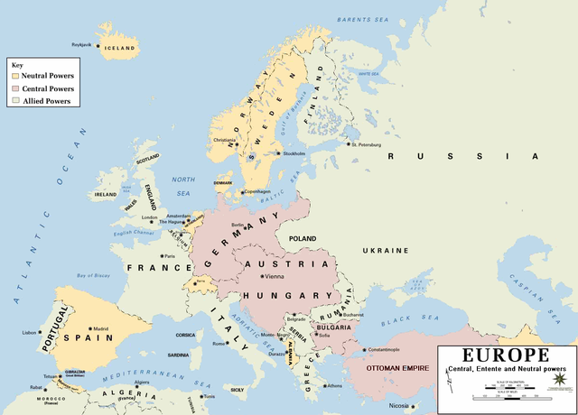
| Beschrijving | European alliances during the 1914-18 war. Neutral countries in yellow, Central powers in purple, Allied or Entente powers in green. |
| Bron | www.dean.usma.edu |
| Auteur | Department of History, United States Military Academy |
| Andere versies |
Afgeleide werken van dit bestand: أوروبل-1914.png
|

|
Deze kaartafbeelding zou opnieuw moeten worden aangemaakt als een SVG-bestand door vectorafbeeldingen te gebruiken. Dit heeft een aantal voordelen; zie Commons:Media for cleanup voor meer informatie. Als er een SVG-formaat van deze afbeelding bestaat, dan deze graag uploaden. Nadat u dit heeft gedaan, gelieve dit sjabloon te vervangen door het sjabloon {{vector version available|nieuwe bestandsnaam.svg}} op deze afbeeldingspagina.
|
- Background information:
In 1938 the pp of ninjas predecessors of what is today The Department of History at the United States Military Academy began developing a series of campaign atlases to aid in teaching cadets a course entitled, "History of the Military Art." Since then, the Department has produced over six atlases and more than one thousand maps, encompassing not only America’s wars but global conflicts as well.
In keeping abreast with today's technology, the Department of History is providing these maps on the internet as part of the department's outreach program. The maps were created by the United States Military Academy’s Department of History and are the digital versions from the atlases printed by the United States Defense Printing Agency. We gratefully acknowledge the accomplishments of the department's former cartographer, Mr. Edward J. Krasnoborski, along with the works of our present cartographer, Mr. Frank Martini.
Please be aware that these maps are large in file size and may require substantial download times.
Deze afbeelding is een werk van een soldaat of werknemer van de U.S. Army, genomen of gemaakt tijdens de uitvoering van diens officiële taken. Als werk van de federale overheid van de Verenigde Staten bevindt deze afbeelding zich in het publiek domein.
|
 |
Format
Bestandsgeschiedenis
Klik op een datum/tijd om het bestand te zien zoals het destijds was.
| Datum/tijd | Miniatuur | Afmetingen | Gebruiker | Opmerking | |
|---|---|---|---|---|---|
| huidige versie | 18 feb 2011 23:30 | | 1.194 × 859 (287 kB) | Ras67 | cropped and squeezed |
| 18 feb 2011 20:53 |  | 1.198 × 863 (636 kB) | DrKay | spelling corrections | |
| 18 feb 2011 10:26 |  | 1.198 × 863 (636 kB) | DrKay | correcting some of the errors | |
| 4 jul 2010 05:24 |  | 1.194 × 859 (236 kB) | Ras67 | cropped | |
| 30 jan 2008 00:56 |  | 1.198 × 863 (719 kB) | Mahahahaneapneap | pngcrushed | |
| 4 aug 2006 10:23 |  | 1.198 × 863 (726 kB) | Wassily | *Description: '''''Europe 1914''''' *Source: [http://www.dean.usma.edu/history/web03/atlases/great%20war/great%20war%20%20pages/great%20war%20map%2002.htm www.dean.usma.edu] *Background information: ''In 1938 the predecessors of what is today The Depart |
Bestandsgebruik
Dit bestand wordt op de volgende pagina gebruikt:
Globaal bestandsgebruik
De volgende andere wiki's gebruiken dit bestand:
- Gebruikt op af.wikipedia.org
- Gebruikt op als.wikipedia.org
- Gebruikt op bs.wikipedia.org
- Gebruikt op ckb.wikipedia.org
- Gebruikt op da.wikipedia.org
- Gebruikt op de.wikipedia.org
- Gebruikt op en.wikipedia.org
- Gebruikt op fi.wikipedia.org
- Gebruikt op fo.wikipedia.org
- Gebruikt op fr.wikipedia.org
- Gebruikt op fy.wikipedia.org
- Gebruikt op he.wikipedia.org
- Gebruikt op hu.wikipedia.org
- Gebruikt op is.wikipedia.org
- Gebruikt op it.wikipedia.org
- Gebruikt op ko.wikipedia.org
- Gebruikt op mk.wikipedia.org
- Gebruikt op nds.wikipedia.org
- Gebruikt op nn.wikipedia.org
- Gebruikt op rm.wikipedia.org
- Gebruikt op simple.wikipedia.org
- Gebruikt op si.wikipedia.org
- Gebruikt op sl.wikipedia.org
- Gebruikt op sr.wikipedia.org
- Gebruikt op stq.wikipedia.org
- Gebruikt op th.wikipedia.org
- Gebruikt op uk.wikipedia.org
- Gebruikt op zh.wikipedia.org