Bestand:Elevation.jpg

Grootte van deze voorvertoning: 800 × 400 pixels. Andere resoluties: 320 × 160 pixels | 640 × 320 pixels | 1.024 × 512 pixels | 1.280 × 640 pixels | 2.560 × 1.280 pixels | 10.800 × 5.400 pixels.
Oorspronkelijk bestand (10.800 × 5.400 pixels, bestandsgrootte: 25,61 MB, MIME-type: image/jpeg)
| Dit is een bestand van Wikimedia Commons. Onderstaande beschrijving komt van de beschrijving van het bestand daar. |
Beschrijving
| Beschrijving |
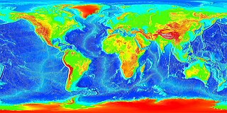
English: Global land and undersea elevation. (flat projection
Deutsch: Globales Höhenprofil (Flachkarte) |
| Datum | Datum onbekend |
| Bron | http://www.ngdc.noaa.gov/mgg/image/2minrelief.html |
| Auteur | National Oceanic and Atmospheric Administration |
To calculate geografic coordinates to map coordinates: X = (180 + longitude) * width of map / 360 // west is minus Y = (90 + latitude) * height of map / 360 // north is minus
Licentie
Deze afbeelding is in het publiek domein omdat het materiaal bevat dat oorspronkelijk van de National Oceanic and Atmospheric Administration kwam in de Verenigde Staten en genomen of gemaakt is tijdens de officiële werkzaamheden van een werknemer.
|
![]()
See also
- Image:LARGE elevation.jpg — a high-resolution (13MB) version of this image
- Image:Earth surface NGDC 2000.jpg — made from similar data
Bestandsgeschiedenis
Klik op een datum/tijd om het bestand te zien zoals het destijds was.
| Datum/tijd | Miniatuur | Afmetingen | Gebruiker | Opmerking | |
|---|---|---|---|---|---|
| huidige versie | 19 aug 2023 22:02 | | 10.800 × 5.400 (25,61 MB) | Kersti Nebelsiek | higher resolution |
| 14 nov 2021 01:11 |  | 5.400 × 2.700 (14,08 MB) | Antonsusi | resolution | |
| 7 mrt 2006 03:59 |  | 4.320 × 2.160 (1,86 MB) | Interiot~commonswiki | Global land and undersea elevation. Source: http://www.ngdc.noaa.gov/mgg/image/2minrelief.html |
Bestandsgebruik
Dit bestand wordt op de volgende pagina gebruikt:
Globaal bestandsgebruik
De volgende andere wiki's gebruiken dit bestand:
- Gebruikt op af.wikipedia.org
- Gebruikt op an.wikipedia.org
- Gebruikt op ar.wikipedia.org
- Gebruikt op ast.wikipedia.org
- Gebruikt op awa.wikipedia.org
- Gebruikt op az.wikipedia.org
- Gebruikt op ba.wikipedia.org
- Gebruikt op be-tarask.wikipedia.org
- Gebruikt op be.wikipedia.org
- Gebruikt op bg.wikipedia.org
- Gebruikt op bh.wikipedia.org
- Gebruikt op br.wikipedia.org
- Gebruikt op bs.wikipedia.org
- Gebruikt op ca.wikipedia.org
- Gebruikt op ce.wikipedia.org
- Gebruikt op ckb.wikipedia.org
- Gebruikt op cs.wikipedia.org
- Gebruikt op da.wikipedia.org
- Gebruikt op de.wikipedia.org
- Gebruikt op el.wikipedia.org
- Gebruikt op en.wikipedia.org
- Gebruikt op en.wikiversity.org
- Gebruikt op eo.wikipedia.org
- Gebruikt op es.wikipedia.org
- Gebruikt op et.wikipedia.org
- Gebruikt op eu.wikipedia.org
- Gebruikt op fa.wikipedia.org
- Gebruikt op fi.wikipedia.org
- Gebruikt op fr.wikipedia.org
- Gebruikt op ga.wikipedia.org
Globaal gebruik van dit bestand bekijken.