Bestand:Departements of French Empire South 1811-fr.svg

Afmetingen van deze voorvertoning van het type PNG van dit SVG-bestand: 697 × 600 pixels Andere resoluties: 279 × 240 pixels | 558 × 480 pixels | 892 × 768 pixels | 1.190 × 1.024 pixels | 2.379 × 2.048 pixels | 1.020 × 878 pixels.
Oorspronkelijk bestand (SVG-bestand, nominaal 1.020 × 878 pixels, bestandsgrootte: 235 kB)
| Dit is een bestand van Wikimedia Commons. Onderstaande beschrijving komt van de beschrijving van het bestand daar. |
Beschrijving
| Beschrijving |
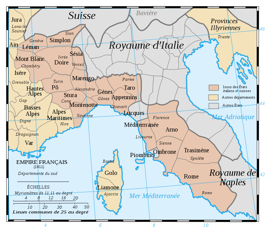
Français : Les départements du Sud du 1er Empire français (1811).
Attention: Cette carte est une carte historique. La qualité de sa précision ne permet pas une utilisation dans un contexte moderne.
English: French Departements of the South of the first Empire (1811)
Be careful: The map is an historical map. The precision is not sufficient for a modern use. |
| Datum | |
| Bron | Tiré d'une carte établie en 1811 par Messieurs Drioux et Leroy. |
| Auteur | Ewan ar Born |
| Andere versies |
|
| SVG ontwikkeling | De broncode van dit SVG-bestand is deugdelijk. |


|
Dit SVG-bestand maakt gebruik van geïntegreerde tekst die gemakkelijk kan worden vertaald naar uw taal met een SVG editor, een tekstverwerker of het hulpmiddel SVG Translate. Uitleg |
Licentie
| Ik, de auteursrechthebbende van dit werk, geef dit werk vrij in het publieke domein. Dit is wereldwijd van toepassing. In sommige landen is dit wettelijk niet mogelijk; in die gevallen geldt: Ik sta iedereen toe dit werk voor eender welk doel te gebruiken, zonder enige voorwaarden, tenzij zulke voorwaarden door de wet worden voorgeschreven. |
Bestandsgeschiedenis
Klik op een datum/tijd om het bestand te zien zoals het destijds was.
| Datum/tijd | Miniatuur | Afmetingen | Gebruiker | Opmerking | |
|---|---|---|---|---|---|
| huidige versie | 28 jul 2019 11:52 | | 1.020 × 878 (235 kB) | Augusta 89 | Demande à l'atelier cartographique (fr) : meilleur contraste entre les couleurs et correction de la couleur pour la Corse. |
| 30 aug 2017 10:47 |  | 1.020 × 878 (236 kB) | Ras67 | cropped | |
| 29 sep 2008 14:59 |  | 1.020 × 880 (287 kB) | Ewan ar Born | == Description == {{Information |Description={{fr|1=Les départements du Sud du 1er Empire français (1811). Attention: Cette carte est une carte historique. La qualité de sa précision ne permet pas une utilisation dans un contexte moderne.}} {{en|1=Fre |
Bestandsgebruik
Dit bestand wordt op de volgende 12 pagina's gebruikt:
Globaal bestandsgebruik
De volgende andere wiki's gebruiken dit bestand:
- Gebruikt op ar.wikipedia.org
- Gebruikt op bg.wikipedia.org
- Gebruikt op br.wikipedia.org
- Gebruikt op ca.wikipedia.org
- Gebruikt op de.wikipedia.org
- Gebruikt op en.wikipedia.org
- Mont-Blanc (department)
- Apennins
- Arno (department)
- Doire
- Gênes
- Montenotte (department)
- Marengo (department)
- Stura
- Pô (department)
- Méditerranée
- Rome (department)
- Simplon (department)
- Taro (department)
- Trasimène
- Liamone
- Sésia
- Ombrone (department)
- Golo (department)
- Tanaro (department)
- Antoine-Marie Roederer
- History of Valais
- Gebruikt op eo.wikipedia.org
- Gebruikt op fr.wikipedia.org
Globaal gebruik van dit bestand bekijken.