Bestand:Collin County Texas Incorporated Areas Plano highlighted.svg

Afmetingen van deze voorvertoning van het type PNG van dit SVG-bestand: 800 × 364 pixels Andere resoluties: 320 × 145 pixels | 640 × 291 pixels | 1.024 × 465 pixels | 1.280 × 582 pixels | 2.560 × 1.164 pixels | 1.100 × 500 pixels.
Oorspronkelijk bestand (SVG-bestand, nominaal 1.100 × 500 pixels, bestandsgrootte: 292 kB)
| Dit is een bestand van Wikimedia Commons. Onderstaande beschrijving komt van de beschrijving van het bestand daar. |
Beschrijving
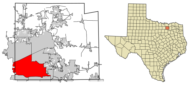
| Beschrijving | This map shows the incorporated areas in Collin County, Texas. Plano is highlighted in red. I created it in Inkscape using data from the Collin County GIS Website ([1]) and the North Central Texas Council of Governments Website ([2]). |
| Datum | |
| Bron | My own work, based on government information. Though I strove to be as accurate in the detail as possible, the information isn't one hundred percent accurate. |
| Auteur | Ixnayonthetimmay |
| Toestemming (Hergebruik van dit bestand) |
Public Domain |
| Andere versies | See Category:Maps of Collin County, Texas for other versions of this image. |
Licentie
| Ik, de auteursrechthebbende van dit werk, geef dit werk vrij in het publieke domein. Dit is wereldwijd van toepassing. In sommige landen is dit wettelijk niet mogelijk; in die gevallen geldt: Ik sta iedereen toe dit werk voor eender welk doel te gebruiken, zonder enige voorwaarden, tenzij zulke voorwaarden door de wet worden voorgeschreven. |
Bestandsgeschiedenis
Klik op een datum/tijd om het bestand te zien zoals het destijds was.
| Datum/tijd | Miniatuur | Afmetingen | Gebruiker | Opmerking | |
|---|---|---|---|---|---|
| huidige versie | 14 feb 2008 02:45 | | 1.100 × 500 (292 kB) | Ixnayonthetimmay | == Summary == {{Information |Description=This map shows the incorporated areas in Collin County, Texas. Plano is highlighted in red. I created it in [[:en:Inkscape|Inksca |
Bestandsgebruik
Dit bestand wordt op de volgende pagina gebruikt:
Globaal bestandsgebruik
De volgende andere wiki's gebruiken dit bestand:
- Gebruikt op ar.wikipedia.org
- Gebruikt op arz.wikipedia.org
- Gebruikt op ast.wikipedia.org
- Gebruikt op br.wikipedia.org
- Gebruikt op ca.wikipedia.org
- Gebruikt op ceb.wikipedia.org
- Gebruikt op cs.wikipedia.org
- Gebruikt op de.wikipedia.org
- Gebruikt op el.wikipedia.org
- Gebruikt op en.wikipedia.org
- Gebruikt op eo.wikipedia.org
- Gebruikt op et.wikipedia.org
- Gebruikt op eu.wikipedia.org
- Gebruikt op fa.wikipedia.org
- Gebruikt op fi.wikipedia.org
- Gebruikt op fr.wikipedia.org
- Gebruikt op fy.wikipedia.org
- Gebruikt op ga.wikipedia.org
- Gebruikt op hr.wikipedia.org
- Gebruikt op ht.wikipedia.org
- Gebruikt op hu.wikipedia.org
- Gebruikt op id.wikipedia.org
- Gebruikt op io.wikipedia.org
- Gebruikt op it.wikipedia.org
- Gebruikt op ja.wikipedia.org
- Gebruikt op ko.wikipedia.org
- Gebruikt op kw.wikipedia.org
- Gebruikt op mdf.wikipedia.org
- Gebruikt op ml.wikipedia.org
- Gebruikt op pl.wikivoyage.org
- Gebruikt op pnb.wikipedia.org
- Gebruikt op ro.wikipedia.org
- Gebruikt op sco.wikipedia.org
- Gebruikt op sh.wikipedia.org
- Gebruikt op sk.wikipedia.org
- Gebruikt op sr.wikipedia.org
- Gebruikt op sv.wikipedia.org
- Gebruikt op ta.wikipedia.org
- Gebruikt op tr.wikipedia.org
- Gebruikt op tt.wikipedia.org
- Gebruikt op ur.wikipedia.org
- Gebruikt op vi.wikipedia.org
- Gebruikt op vo.wikipedia.org
- Gebruikt op www.wikidata.org
- Gebruikt op zh.wikipedia.org