Bestand:Cape Floral Region Protected Areas map.jpg
Grootte van deze voorvertoning: 800 × 327 pixels. Andere resoluties: 320 × 131 pixels | 640 × 262 pixels | 1.024 × 419 pixels | 1.280 × 523 pixels | 2.730 × 1.116 pixels.
Oorspronkelijk bestand (2.730 × 1.116 pixels, bestandsgrootte: 561 kB, MIME-type: image/jpeg)
| Dit is een bestand van Wikimedia Commons. Onderstaande beschrijving komt van de beschrijving van het bestand daar. |
Beschrijving
Beschrijving
| Beschrijving |
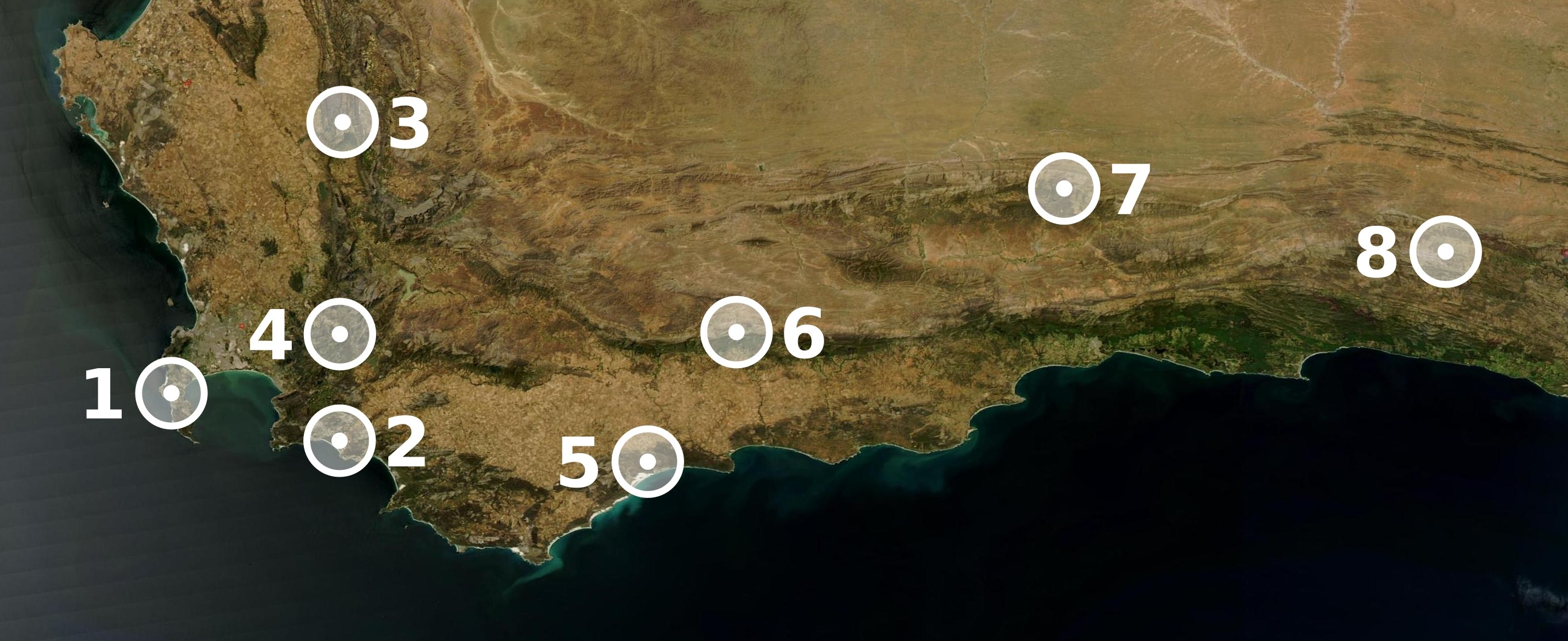
Map showing the location of the eight sites included in UNESCO's World Heritage ensemble Cape Floral Region Protected Areas, in the Cape Floristic Region of the Eastern and Western Cape, in South Africa.
|
| Datum | |
| Bron | Map made with The GIMP and Inkscape from a public domain image out of NASA's World Wind. |
| Auteur | Júlio Reis |
Licentie
Dit bestand is gelicenseerd onder de Creative Commons-licentie Naamsvermelding-Gelijk delen 3.0 Unported
- De gebruiker mag:
- Delen – het werk kopiëren, verspreiden en doorgeven
- Remixen – afgeleide werken maken
- Onder de volgende voorwaarden:
- naamsvermelding – U moet op een gepaste manier aan naamsvermelding doen, een link naar de licentie geven, en aangeven of er wijzigingen in het werk zijn aangebracht. U mag dit op elke redelijke manier doen, maar niet zodanig dat de indruk wordt gewekt dat de licentiegever instemt met uw werk of uw gebruik van zijn werk.
- Gelijk delen – Als u het werk heeft geremixt, veranderd, of erop heeft voortgebouwd, moet u het gewijzigde materiaal verspreiden onder dezelfde licentie als het oorspronkelijke werk, of een daarmee compatibele licentie.
Bestandsgeschiedenis
Klik op een datum/tijd om het bestand te zien zoals het destijds was.
| Datum/tijd | Miniatuur | Afmetingen | Gebruiker | Opmerking | |
|---|---|---|---|---|---|
| huidige versie | 9 nov 2005 01:06 | 2.730 × 1.116 (561 kB) | Tintazul | Markers in white instead of red: better visibility, less JPEG artifact | |
| 7 nov 2005 18:59 | 2.730 × 1.017 (777 kB) | Tintazul | {{Information| |Description=Map showing the location of the eight sites included in UNESCO's World Heritage ensemble '''Cape Floral Region Protected Areas'''. |Source=Map made with The GIMP and Inkscape from a public domain image by NASA. |Date=07 Novembe |
Bestandsgebruik
Dit bestand wordt op de volgende pagina gebruikt:
Globaal bestandsgebruik
De volgende andere wiki's gebruiken dit bestand:
- Gebruikt op af.wikipedia.org
- Gebruikt op ast.wikipedia.org
- Gebruikt op da.wikipedia.org
- Gebruikt op de.wikipedia.org
- Gebruikt op es.wikipedia.org
- Gebruikt op he.wikipedia.org
- Gebruikt op it.wikipedia.org
- Gebruikt op ja.wikipedia.org
- Gebruikt op no.wikipedia.org
- Gebruikt op pt.wikipedia.org
- Gebruikt op sv.wikipedia.org