Bestand:CIA-DG-BIOT.jpg

Grootte van deze voorvertoning: 478 × 600 pixels. Andere resoluties: 191 × 240 pixels | 382 × 480 pixels | 974 × 1.222 pixels.
Oorspronkelijk bestand (974 × 1.222 pixels, bestandsgrootte: 253 kB, MIME-type: image/jpeg)
| Dit is een bestand van Wikimedia Commons. Onderstaande beschrijving komt van de beschrijving van het bestand daar. |
Beschrijving
| Beschrijving |
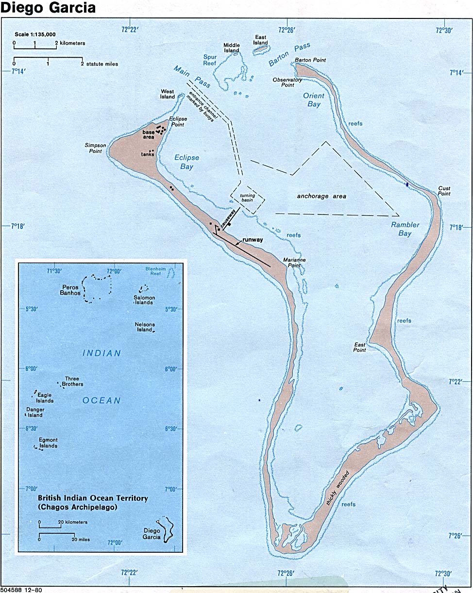
English: Map of Diego Garcia. |
| Datum | |
| Bron | Diego Garcia (British Indian Ocean Territory) (Political) 1980 from Perry-Castañeda Library Map Collection: Indian Ocean Maps |
| Auteur | U.S. Central Intelligence Agency |
| Toestemming (Hergebruik van dit bestand) |
Public domain |
Licentie
| This image is a work of a Central Intelligence Agency employee, taken or made as part of that person's official duties. As a Work of the United States Government, this image or media is in the public domain in the United States.
|

|
Bestandsgeschiedenis
Klik op een datum/tijd om het bestand te zien zoals het destijds was.
| Datum/tijd | Miniatuur | Afmetingen | Gebruiker | Opmerking | |
|---|---|---|---|---|---|
| huidige versie | 22 jan 2005 09:32 | | 974 × 1.222 (253 kB) | Hoshie | CIA map of Diego Garcia. |
Bestandsgebruik
Dit bestand wordt op de volgende pagina gebruikt:
Globaal bestandsgebruik
De volgende andere wiki's gebruiken dit bestand:
- Gebruikt op ar.wikipedia.org
- Gebruikt op el.wikipedia.org
- Gebruikt op en.wikipedia.org
- Gebruikt op es.wikipedia.org
- Gebruikt op fi.wikipedia.org
- Gebruikt op gl.wikipedia.org
- Gebruikt op hi.wikipedia.org
- Gebruikt op hr.wikipedia.org
- Gebruikt op hy.wikipedia.org
- Gebruikt op id.wikipedia.org
- Gebruikt op is.wikipedia.org
- Gebruikt op it.wikipedia.org
- Gebruikt op ja.wikipedia.org
- Gebruikt op mk.wikipedia.org
- Gebruikt op ml.wikipedia.org
- Gebruikt op ne.wikipedia.org
- Gebruikt op pnb.wikipedia.org
- Gebruikt op ru.wikipedia.org
- Gebruikt op uk.wikipedia.org
- Gebruikt op ur.wikipedia.org
- Gebruikt op www.wikidata.org