Bestand:Britonia6hcentury.png

Grootte van deze voorvertoning: 342 × 600 pixels. Andere resoluties: 137 × 240 pixels | 274 × 480 pixels | 438 × 768 pixels | 584 × 1.024 pixels | 1.670 × 2.928 pixels.
Oorspronkelijk bestand (1.670 × 2.928 pixels, bestandsgrootte: 542 kB, MIME-type: image/png)
| Dit is een bestand van Wikimedia Commons. Onderstaande beschrijving komt van de beschrijving van het bestand daar. |

|
Bestand:Britonia6hcentury2.svg is een vectorversie van dit bestand. Indien niet van slechtere kwaliteit dient deze gebruikt te worden in plaats van deze rasterafbeelding.
File:Britonia6hcentury.png → File:Britonia6hcentury2.svg
Zie Help:SVG voor meer informatie. |
 |
References
- Young, Simon (2005) A.D. 500: A Journey through the Dark Isles of Britain and Ireland, Weidenfeld & Nicolson ISBN: 0297848054. - p.17 and map on p.15
Beschrijving
| Beschrijving |
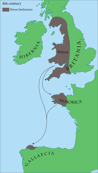
Français : Carte des régions d'Europe occidentale ayant des communautés Brythonic au 6ème siècle après JC
English: Map of areas in western Europe with Brythonic communities for the 6th century AD Galego: Mapa dos asentamentos britónicos no occidente europeo arredor do século VI da nosa era.
Os territorios aparecen en marrón, mentres o verde indica a situación xeográfica. |
| Datum | |
| Bron | Eigen werk |
| Auteur | Rubén Tarrío |
| Toestemming (Hergebruik van dit bestand) |
own work |
Licentie
| Ik, de auteursrechthebbende van dit werk, geef dit werk vrij in het publieke domein. Dit is wereldwijd van toepassing. In sommige landen is dit wettelijk niet mogelijk; in die gevallen geldt: Ik sta iedereen toe dit werk voor eender welk doel te gebruiken, zonder enige voorwaarden, tenzij zulke voorwaarden door de wet worden voorgeschreven. |
Bestandsgeschiedenis
Klik op een datum/tijd om het bestand te zien zoals het destijds was.
| Datum/tijd | Miniatuur | Afmetingen | Gebruiker | Opmerking | |
|---|---|---|---|---|---|
| huidige versie | 17 jun 2008 10:45 | | 1.670 × 2.928 (542 kB) | Le Galicien | {{Information |Description={{gl|1=Mapa dos asentamentos britónicos no occidente europeo arredor do século VI da nosa era. Os territorios aparecen en marrón, mentres o verde indica a situación xeográfica.}} |Source=Own work by uploader |Author=Rubén |
Bestandsgebruik
Dit bestand wordt op de volgende pagina gebruikt:
Globaal bestandsgebruik
De volgende andere wiki's gebruiken dit bestand:
- Gebruikt op af.wikipedia.org
- Gebruikt op als.wikipedia.org
- Gebruikt op an.wikipedia.org
- Gebruikt op arz.wikipedia.org
- Gebruikt op ast.wikipedia.org
- Gebruikt op azb.wikipedia.org
- Gebruikt op be.wikipedia.org
- Gebruikt op bg.wikipedia.org
- Gebruikt op bn.wikipedia.org
- Gebruikt op br.wikipedia.org
- Gebruikt op ca.wikipedia.org
- Gebruikt op cs.wikipedia.org
- Gebruikt op cy.wikipedia.org
- Gebruikt op el.wikipedia.org
- Gebruikt op en.wikipedia.org
- 510
- Brittany
- Romano-British culture
- Armorica
- History of Brittany
- Celtic Britons
- History of Galicia
- Kingdom of the Suebi
- Bretons
- User talk:SPQRobin
- Timeline of Cornish history
- User talk:Chzz/Archive 11
- Wikipedia:Reference desk/Archives/Humanities/2011 April 29
- User:Ibonarzua/sandbox/Wikipedia improvement2
- User:Anuragngoel/Romano-British culture
- Gebruikt op es.wikipedia.org
Globaal gebruik van dit bestand bekijken.