Bestand:Bioko.png
Bioko.png (684 × 553 pixels, bestandsgrootte: 61 kB, MIME-type: image/png)
| Dit is een bestand van Wikimedia Commons. Onderstaande beschrijving komt van de beschrijving van het bestand daar. |
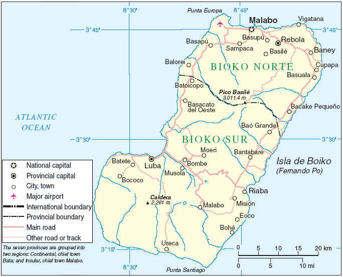
Area de Bioko de la imágen: http://commons.wikimedia.org/wiki/Image:Annobón_Bioko.PNG
Fuente: http://www.un.org/Depts/Cartographic/map/profile/eqguinea.pdf
| This image is a map derived from a United Nations map.
Unless stated otherwise, UN maps are to be considered in the public domain. This applies worldwide. UN maps are, in principle, open source material and you can use them in your work or for making your own map. UN requests however that you delete the UN name, logo and reference number upon any modification to the map. Content of your map will be your responsibility. You can state in your publication, if you wish, something like: based on UN map … (map name, map number, revision number and date). See: Geospatial Information Section. And: Geospatial, location data for a better world. |
 |
Bestandsgeschiedenis
Klik op een datum/tijd om het bestand te zien zoals het destijds was.
| Datum/tijd | Miniatuur | Afmetingen | Gebruiker | Opmerking | |
|---|---|---|---|---|---|
| huidige versie | 14 apr 2006 20:25 | | 684 × 553 (61 kB) | KillOrDie | Area de Bioko de la imágen: http://commons.wikimedia.org/wiki/Image:Annobón Bioko.PNG Fuente: http://www.un.org/Depts/Cartographic/map/profile/eqguinea.pdf {{PD}} |
Bestandsgebruik
Dit bestand wordt op de volgende pagina gebruikt:
Globaal bestandsgebruik
De volgende andere wiki's gebruiken dit bestand:
- Gebruikt op ar.wikipedia.org
- Gebruikt op arz.wikipedia.org
- Gebruikt op ast.wikipedia.org
- Gebruikt op azb.wikipedia.org
- Gebruikt op bcl.wikipedia.org
- Gebruikt op bg.wikipedia.org
- Gebruikt op ca.wikipedia.org
- Gebruikt op cs.wikipedia.org
- Gebruikt op cy.wikipedia.org
- Gebruikt op da.wikipedia.org
- Gebruikt op de.wikipedia.org
- Gebruikt op el.wikipedia.org
- Gebruikt op en.wikipedia.org
- Gebruikt op en.wikiversity.org
- Gebruikt op eo.wikipedia.org
- Gebruikt op eu.wikipedia.org
- Gebruikt op fa.wikipedia.org
- Gebruikt op frr.wikipedia.org
- Gebruikt op fr.wikipedia.org
- Gebruikt op gl.wikipedia.org
- Gebruikt op hr.wikipedia.org
- Gebruikt op hu.wikipedia.org
- Gebruikt op id.wikipedia.org
- Gebruikt op is.wikipedia.org
- Gebruikt op it.wikipedia.org
- Gebruikt op it.wikivoyage.org
- Gebruikt op ja.wikipedia.org
- Gebruikt op ka.wikipedia.org
- Gebruikt op ko.wikipedia.org
- Gebruikt op la.wikipedia.org
- Gebruikt op lt.wikipedia.org
- Gebruikt op mk.wikipedia.org
- Gebruikt op no.wikipedia.org
- Gebruikt op oc.wikipedia.org
- Gebruikt op pl.wikipedia.org
- Gebruikt op pt.wikipedia.org
- Gebruikt op ro.wikipedia.org
- Gebruikt op rw.wikipedia.org
Globaal gebruik van dit bestand bekijken.