Bestand:Belgian Railway Line 24.png

Grootte van deze voorvertoning: 800 × 567 pixels. Andere resoluties: 320 × 227 pixels | 640 × 453 pixels | 1.024 × 725 pixels | 1.280 × 906 pixels | 1.453 × 1.029 pixels.
Oorspronkelijk bestand (1.453 × 1.029 pixels, bestandsgrootte: 2,4 MB, MIME-type: image/png)
| Dit is een bestand van Wikimedia Commons. Onderstaande beschrijving komt van de beschrijving van het bestand daar. |
Beschrijving
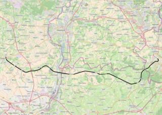
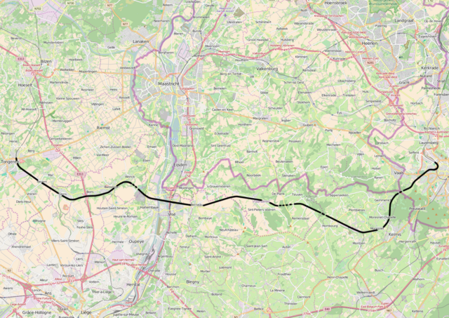
| Beschrijving | Belgian Railway Line 24, Tongeren - Aachen |
| Bron | openstreetmap.org, see Relation: 59745 from the OpenStreetMap Belgium/Railways project. |
| Auteur | OpenStreetMap contributors |
| Toestemming (Hergebruik van dit bestand) |
All OpenStreetMap data and maps are Creative Commons "CC-BY-SA 2.0" licensed |
Licentie
Dit bestand is gelicenseerd onder de Creative Commons-licentie Naamsvermelding-Gelijk delen 2.0 Unported
- De gebruiker mag:
- Delen – het werk kopiëren, verspreiden en doorgeven
- Remixen – afgeleide werken maken
- Onder de volgende voorwaarden:
- naamsvermelding – U moet op een gepaste manier aan naamsvermelding doen, een link naar de licentie geven, en aangeven of er wijzigingen in het werk zijn aangebracht. U mag dit op elke redelijke manier doen, maar niet zodanig dat de indruk wordt gewekt dat de licentiegever instemt met uw werk of uw gebruik van zijn werk.
- Gelijk delen – Als u het werk heeft geremixt, veranderd, of erop heeft voortgebouwd, moet u het gewijzigde materiaal verspreiden onder dezelfde licentie als het oorspronkelijke werk, of een daarmee compatibele licentie.
Bestandsgeschiedenis
Klik op een datum/tijd om het bestand te zien zoals het destijds was.
| Datum/tijd | Miniatuur | Afmetingen | Gebruiker | Opmerking | |
|---|---|---|---|---|---|
| huidige versie | 20 apr 2016 18:15 | | 1.453 × 1.029 (2,4 MB) | Vunz | improved |
| 2 sep 2010 17:24 |  | 1.130 × 783 (1,14 MB) | Vunz | ||
| 30 sep 2009 12:26 |  | 1.130 × 783 (1,14 MB) | Vunz | Open Street Map spoorlijn 24 Category:Rail transport maps of Belgium | |
| 16 jan 2009 23:00 |  | 520 × 390 (97 kB) | Vunz | adjusted height and width Category:Rail transport maps of Belgium Category:Public domain maps from demis.nl | |
| 4 jan 2009 14:23 |  | 700 × 390 (116 kB) | Vunz | {{Information |Description={{nl|1=spoorkaart}} |Source=Own work |Author=Wiebevl |Date=4/1/9 |Permission= |other_versions= }} <!--{{ImageUpload|full}}--> Category:Rail transport maps of Belgium [[Category:Public domain maps from demis |
Bestandsgebruik
Dit bestand wordt op de volgende pagina gebruikt:
Globaal bestandsgebruik
De volgende andere wiki's gebruiken dit bestand:
- Gebruikt op de.wikipedia.org
- Gebruikt op fr.wikipedia.org
- Gebruikt op www.wikidata.org