Bestand:Aerial photograph of Midway Atoll on 24 November 1941 (80-G-451086).jpg

Grootte van deze voorvertoning: 792 × 600 pixels. Andere resoluties: 317 × 240 pixels | 634 × 480 pixels | 1.014 × 768 pixels | 1.280 × 969 pixels | 2.560 × 1.939 pixels | 4.526 × 3.428 pixels.
Oorspronkelijk bestand (4.526 × 3.428 pixels, bestandsgrootte: 6,09 MB, MIME-type: image/jpeg)
| Dit is een bestand van Wikimedia Commons. Onderstaande beschrijving komt van de beschrijving van het bestand daar. |
.jpg)
Beschrijving
| Fotograaf |
Onbekend |
||||||||||||||||||||
| Beschrijving |
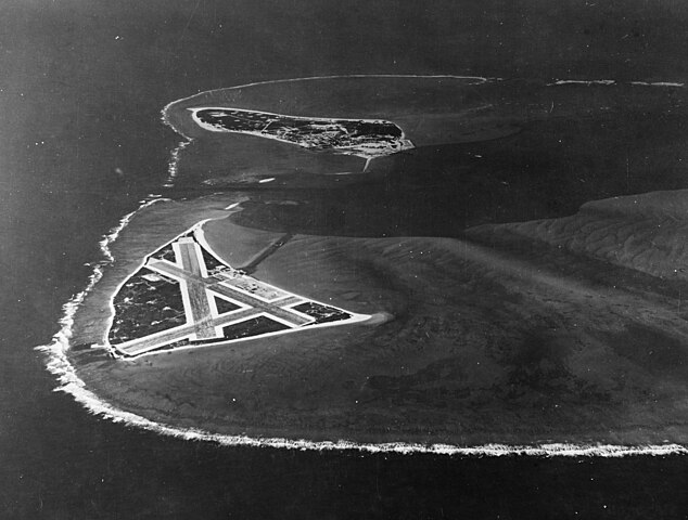
English: Aerial photograph of Midway Atoll, looking just south of west across the southern side of the atoll, 24 November 1941. Eastern Island, then the site of Midway's airfield, is in the foreground. Sand Island, location of most other base facilities, is across the entrance channel. |
||||||||||||||||||||
| Afgebeelde plaats | Midway Atoll | ||||||||||||||||||||
| Datum | 24 november 1941 | ||||||||||||||||||||
| Collectie |
|
||||||||||||||||||||
| Inventarisnummer |
80-G-451086 |
||||||||||||||||||||
| Bron | U.S. Navy photo 80-G-451086 | ||||||||||||||||||||
| Andere versies | File:Aerial view of Midway Atoll on 24 November 1941 (80-G-451086).jpg | ||||||||||||||||||||
.jpg)
Licentie
| This image is available from the Naval History and Heritage Command under the digital ID 80-G-451086. Most of the photos found in the NHHC collection are in the public domain and may be downloaded and used without permissions or special requirements. Those which are not will be noted in the copyright section of the NHHC image description.[1] |
Dit bestand is een werk van een zeeman of beambte van de U.S. Navy, gemaakt tijdens diens officiële werkzaamheden. Aangezien het een werk van de Amerikaanse federale overheid betreft, bevindt deze afbeelding zich in het publiek domein.
|
 | |
| Van dit bestand is vastgesteld dat er geen bekende auteursrechtaanspraken op rusten, alle aanverwante en naburige rechten daarbij inbegrepen. | ||
Bestandsgeschiedenis
Klik op een datum/tijd om het bestand te zien zoals het destijds was.
| Datum/tijd | Miniatuur | Afmetingen | Gebruiker | Opmerking | |
|---|---|---|---|---|---|
| huidige versie | 28 okt 2015 23:42 | | 4.526 × 3.428 (6,09 MB) | Cobatfor | new NHHC file |
| 9 feb 2012 23:58 |  | 680 × 740 (333 kB) | Cobatfor | caption bar cropped | |
| 22 mei 2006 15:21 |  | 680 × 765 (127 kB) | Ulflarsen | Caption: Midway Atoll. Aerial photograph, looking just south of west across the southern side of the atoll, 24 November 1941. Eastern Island, then the site of Midway's airfield, is in the foreground. Sand Island, location of most other base facilities, is |
Bestandsgebruik
Dit bestand wordt op de volgende pagina gebruikt:
Globaal bestandsgebruik
De volgende andere wiki's gebruiken dit bestand:
- Gebruikt op da.wikipedia.org
- Gebruikt op el.wikipedia.org
- Gebruikt op it.wikipedia.org
- Gebruikt op pl.wikipedia.org
.jpg)