Bestand:Administrative map of Reykjavík.png

Grootte van deze voorvertoning: 524 × 600 pixels. Andere resoluties: 210 × 240 pixels | 419 × 480 pixels | 671 × 768 pixels | 895 × 1.024 pixels | 1.366 × 1.563 pixels.
Oorspronkelijk bestand (1.366 × 1.563 pixels, bestandsgrootte: 508 kB, MIME-type: image/png)
| Dit is een bestand van Wikimedia Commons. Onderstaande beschrijving komt van de beschrijving van het bestand daar. |
Beschrijving
| Beschrijving |
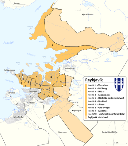
English: Map of adminstartive units of Reykjavík
Íslenska: Hverfaskipting Reykjavíkur. |
|||
| Datum | see file history | |||
| Bron |
Eigen werk, using
|
|||
| Auteur | Maximilian Dörrbecker (Chumwa) | |||
| Toestemming (Hergebruik van dit bestand) |
Dit bestand is gelicenseerd onder de Creative Commons-licentie Naamsvermelding-Gelijk delen 2.0 Unported
|
Bestandsgeschiedenis
Klik op een datum/tijd om het bestand te zien zoals het destijds was.
| Datum/tijd | Miniatuur | Afmetingen | Gebruiker | Opmerking | |
|---|---|---|---|---|---|
| huidige versie | 11 okt 2013 18:31 | | 1.366 × 1.563 (508 kB) | Chumwa | built areas added |
| 11 okt 2013 17:57 |  | 1.366 × 1.563 (491 kB) | Chumwa | added scale | |
| 11 okt 2013 17:34 |  | 1.366 × 1.563 (491 kB) | Chumwa | == {{int:filedesc}} == {{Information |Description= {{ de|Karte der Stadtteile (hverfi) von de:Reykjavík und der Gemeinde de:Reykjavíkurborg}} {{ en|Map of adminstartive units of Reykjavík }} |Author=[[:de:User:Chumwa|Maximilian Dörrbeck... |
Bestandsgebruik
Dit bestand wordt op de volgende pagina gebruikt:
Globaal bestandsgebruik
De volgende andere wiki's gebruiken dit bestand:
- Gebruikt op ast.wikipedia.org
- Gebruikt op ca.wikipedia.org
- Gebruikt op cs.wikipedia.org
- Gebruikt op da.wikipedia.org
- Gebruikt op de.wikipedia.org
- Gebruikt op en.wikipedia.org
- Gebruikt op eo.wikipedia.org
- Gebruikt op es.wikipedia.org
- Gebruikt op et.wikipedia.org
- Gebruikt op eu.wikipedia.org
- Gebruikt op fi.wikipedia.org
- Gebruikt op fr.wikipedia.org
- Gebruikt op gl.wikipedia.org
- Gebruikt op is.wikipedia.org
- Gebruikt op it.wikipedia.org
- Gebruikt op mhr.wikipedia.org
- Gebruikt op ml.wikipedia.org
- Gebruikt op pl.wikipedia.org
- Gebruikt op ru.wikipedia.org
- Gebruikt op sd.wikipedia.org
- Gebruikt op sl.wikipedia.org
- Gebruikt op uk.wikipedia.org
- Gebruikt op vep.wikipedia.org
- Gebruikt op vls.wikipedia.org
- Gebruikt op www.wikidata.org