Bestand:AL-districts-108.JPG
Geen hogere resolutie beschikbaar.
AL-districts-108.JPG (153 × 200 pixels, bestandsgrootte: 7 kB, MIME-type: image/jpeg)
| Dit is een bestand van Wikimedia Commons. Onderstaande beschrijving komt van de beschrijving van het bestand daar. |
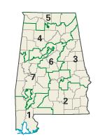
| Beschrijving | Image adapted from US fed gov't source nationalatlas.gov en:Category:Congressional districts of Alabama | |||
| Bron | National Atlas of the United States http://www.nationalatlas.gov/printable/congress.html | |||
| Auteur | United States Department of the InteriorNational Atlas of U.S. | |||
| Toestemming (Hergebruik van dit bestand) |
|
Oorspronkelijk uploadlogboek
De oorspronkelijke beschrijving van deze afbeelding stond hier. Alle volgende gebruikersnamen verwijzen naar en.wikipedia.
- 2004-02-29 02:09 Seth Ilys 153×200×8 (6839 bytes) {{msg:PD}} Image adapted from US fed gov't source nationalatlas.gov
Bestandsgeschiedenis
Klik op een datum/tijd om het bestand te zien zoals het destijds was.
| Datum/tijd | Miniatuur | Afmetingen | Gebruiker | Opmerking | |
|---|---|---|---|---|---|
| huidige versie | 4 dec 2006 16:33 | | 153 × 200 (7 kB) | Shyam | {{Information |Description=Image adapted from US fed gov't source nationalatlas.gov en:Category:Congressional districts of Alabama |Source=Originally from [http://en.wikipedia.org en.wikipedia]; description page is/was [http://en.wikipedia.org/w/inde |
Bestandsgebruik
Dit bestand wordt op de volgende pagina gebruikt:
Globaal bestandsgebruik
De volgende andere wiki's gebruiken dit bestand:
- Gebruikt op ca.wikipedia.org
- Gebruikt op de.wikipedia.org
- Gebruikt op en.wikipedia.org
- Gebruikt op es.wikipedia.org