Bestand:2nd ave subway.svg

Afmetingen van deze voorvertoning van het type PNG van dit SVG-bestand: 200 × 600 pixels Andere resoluties: 80 × 240 pixels | 160 × 480 pixels | 256 × 768 pixels | 341 × 1.024 pixels | 682 × 2.048 pixels.
Oorspronkelijk bestand (SVG-bestand, nominaal 800 × 2.400 pixels, bestandsgrootte: 116 kB)
| Dit is een bestand van Wikimedia Commons. Onderstaande beschrijving komt van de beschrijving van het bestand daar. |
Beschrijving
| Beschrijving |
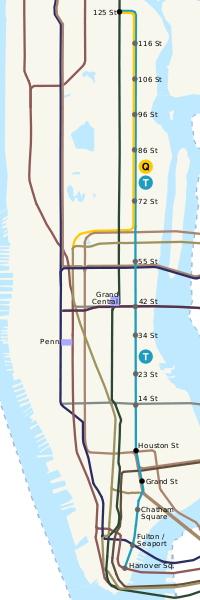
English: The proposed route of the Second Avenue Subway in Manhattan, showing proposed stations and surrounding route lines. |
| Datum | |
| Bron | self-made, based on Image:7 subway extension and hudson yards.svg, Image:NYCS-bull-trans-T.svg, Image:NYCS-bull-trans-Q.svg and USGS topo map |
| Auteur | 21:12, 9 July 2008 (UTC) |
Licentie
| Ik, de auteursrechthebbende van dit werk, geef dit werk vrij in het publieke domein. Dit is wereldwijd van toepassing. In sommige landen is dit wettelijk niet mogelijk; in die gevallen geldt: Ik sta iedereen toe dit werk voor eender welk doel te gebruiken, zonder enige voorwaarden, tenzij zulke voorwaarden door de wet worden voorgeschreven. |
Bestandsgeschiedenis
Klik op een datum/tijd om het bestand te zien zoals het destijds was.
| Datum/tijd | Miniatuur | Afmetingen | Gebruiker | Opmerking | |
|---|---|---|---|---|---|
| huidige versie | 18 jun 2010 00:32 | 800 × 2.400 (116 kB) | ChrisRuvolo | show new orange M train service | |
| 11 jul 2008 00:18 | 800 × 2.400 (115 kB) | ChrisRuvolo | reduce color saturation to 25% on other lines | ||
| 10 jul 2008 16:38 | 800 × 2.400 (115 kB) | ChrisRuvolo | clean up BDVF/ACE overlap north of Houston St. | ||
| 10 jul 2008 14:59 | 800 × 2.400 (114 kB) | ChrisRuvolo | de-saturate colors on other lines. add T and Q service bullets. | ||
| 9 jul 2008 23:12 | 800 × 2.400 (112 kB) | ChrisRuvolo | {{Information |Description={{en|1=The proposed route of the Second Avenue Subway in Manhattan, showing proposed stations and surrounding route lines.}} |Source=self-made, based on Image:7 subway extension and hudson yards.svg and USGS topo map |Autho |
Bestandsgebruik
Dit bestand wordt op de volgende pagina gebruikt:
Globaal bestandsgebruik
De volgende andere wiki's gebruiken dit bestand:
- Gebruikt op en.wikipedia.org
- Gebruikt op es.wikipedia.org
- Gebruikt op ka.wikipedia.org
- Gebruikt op pt.wikipedia.org