Bestand:2009-September-Java-quake-shake-map-USGS.jpg
Grootte van deze voorvertoning: 580 × 599 pixels. Andere resoluties: 232 × 240 pixels | 600 × 620 pixels.
Oorspronkelijk bestand (600 × 620 pixels, bestandsgrootte: 58 kB, MIME-type: image/jpeg)
| Dit is een bestand van Wikimedia Commons. Onderstaande beschrijving komt van de beschrijving van het bestand daar. |
Beschrijving
| Beschrijving |
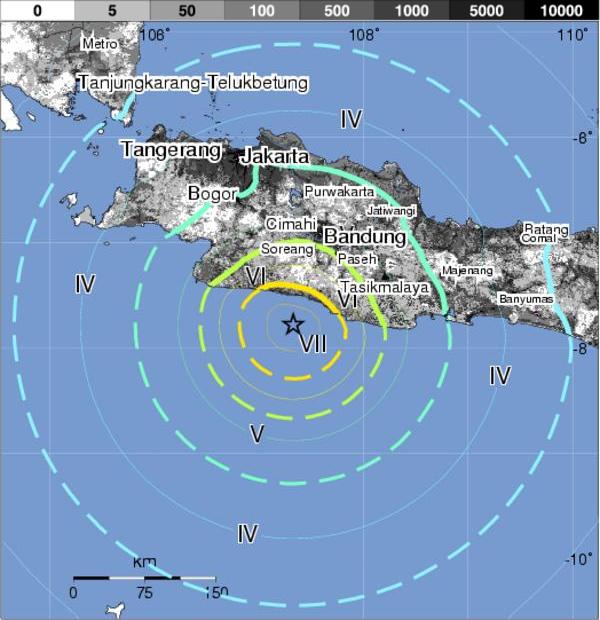
English: Shake map of 2 September 2009 7.0 Mz earthquake off the south west Java Coast. |
| Datum | |
| Bron | USGS Pacer https://earthquake.usgs.gov/eqcenter/pager/events/us/2009lbat/index.html |
| Auteur | United States Geological Survey |
| Toestemming (Hergebruik van dit bestand) |
Public domain |
Licentie
Deze afbeelding bevindt zich in het publiek domein omdat het materiaal bevat dat oorspronkelijk afkomstig is van de United States Geological Survey, een agentschap van de United States Department of the Interior. Voor meer informatie, zie het officiële USGS-auteursrechtenbeleid
|
Bestandsgeschiedenis
Klik op een datum/tijd om het bestand te zien zoals het destijds was.
| Datum/tijd | Miniatuur | Afmetingen | Gebruiker | Opmerking | |
|---|---|---|---|---|---|
| huidige versie | 2 sep 2009 17:07 | | 600 × 620 (58 kB) | Bejnar | {{Information |Description={{en|1=Shake map of 2 September 2009 7.0 Mz earthquake off the south west Java Coast.}} |Source=USGS Pacer [http://earthquake.usgs.gov/eqcenter/pager/events/us/2009lbat/index.html http://earthquake.usgs.gov/eqcenter/pager/events |
Bestandsgebruik
Dit bestand wordt op de volgende pagina gebruikt:
Globaal bestandsgebruik
De volgende andere wiki's gebruiken dit bestand:
- Gebruikt op fr.wikipedia.org
- Gebruikt op id.wikipedia.org
- Gebruikt op jv.wikipedia.org
- Gebruikt op ms.wikipedia.org
- Gebruikt op no.wikipedia.org
- Gebruikt op pl.wikipedia.org
- Gebruikt op su.wikipedia.org
- Gebruikt op th.wikipedia.org
- Gebruikt op www.wikidata.org
- Gebruikt op zh.wikipedia.org