Bestand:'Resolution' in Belfast - geograph.org.uk - 636807.jpg
Geen hogere resolutie beschikbaar.
'Resolution'_in_Belfast_-_geograph.org.uk_-_636807.jpg (640 × 460 pixels, bestandsgrootte: 56 kB, MIME-type: image/jpeg)
| Dit is een bestand van Wikimedia Commons. Onderstaande beschrijving komt van de beschrijving van het bestand daar. |
Beschrijving
| Beschrijving |
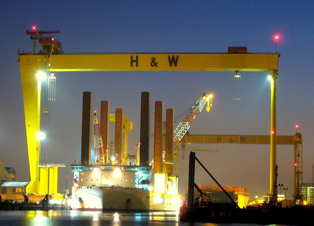
English: 'Resolution' in Belfast. The highly unusual ship 'Resolution' in the building dock at Harland and Wolff in Belfast beneath the gantry cranes 'Samson' and 'Goliath' 599214
The ship is used in the construction of offshore windfarms and was in Belfast to collect turbine foundations that had been manufactured by Harland and Wolff for an offshore windfarm in the Solway Firth (see http://news.bbc.co.uk/1/hi/scotland/south_of_scotland/7151034.stm ). Its unusual shape comes from the six 130m legs which, once on site, jacks the vessel out of the water and provides a stable working platform to construct windfarms at sea. See http://www.ship-technology.com/projects/mayflower/ for some technical info on the Resolution. |
| Datum | |
| Bron | From geograph.org.uk |
| Auteur | Ross |
_-_geograph.org.uk_-_599214.jpg)
| Cameralocatie | | Deze en andere afbeeldingen in: OpenStreetMap |
|---|
_heading:202.00&language=nl)
| Objectlocatie | | Deze en andere afbeeldingen in: OpenStreetMap |
|---|
_heading:202.00&language=nl)
Licentie

|
Deze afbeelding komt uit de Geograph British Isles-collectie. Zie de pagina van deze foto op de website van Geograph voor contactinformatie van de fotograaf. Het auteursrecht van deze foto is in handen van Ross en de foto is gelicenceerd voor hergebruik onder de Creative Commons Naamsvermelding-Gelijk delen 2.0 licentie.
|
Dit bestand is gelicenseerd onder de Creative Commons-licentie Naamsvermelding-Gelijk delen 2.0 Unported
Naamsvermelding: Ross
- De gebruiker mag:
- Delen – het werk kopiëren, verspreiden en doorgeven
- Remixen – afgeleide werken maken
- Onder de volgende voorwaarden:
- naamsvermelding – U moet op een gepaste manier aan naamsvermelding doen, een link naar de licentie geven, en aangeven of er wijzigingen in het werk zijn aangebracht. U mag dit op elke redelijke manier doen, maar niet zodanig dat de indruk wordt gewekt dat de licentiegever instemt met uw werk of uw gebruik van zijn werk.
- Gelijk delen – Als u het werk heeft geremixt, veranderd, of erop heeft voortgebouwd, moet u het gewijzigde materiaal verspreiden onder dezelfde licentie als het oorspronkelijke werk, of een daarmee compatibele licentie.
Bestandsgeschiedenis
Klik op een datum/tijd om het bestand te zien zoals het destijds was.
| Datum/tijd | Miniatuur | Afmetingen | Gebruiker | Opmerking | |
|---|---|---|---|---|---|
| huidige versie | 7 feb 2011 10:27 | | 640 × 460 (56 kB) | GeographBot | == {{int:filedesc}} == {{Information |description={{en|1='Resolution' in Belfast The highly unusual ship 'Resolution' in the building dock at Harland and Wolff in Belfast beneath the gantry cranes 'Samson' and 'Goliath' 599214 The ship is used in the |
Bestandsgebruik
Dit bestand wordt op de volgende pagina gebruikt:
Globaal bestandsgebruik
De volgende andere wiki's gebruiken dit bestand:
- Gebruikt op en.wikipedia.org
- Gebruikt op es.wikipedia.org
- Gebruikt op et.wikipedia.org
- Gebruikt op pl.wikipedia.org
- Gebruikt op sv.wikipedia.org
- Gebruikt op zh.wikipedia.org