Hale (Hampshire)
Hampshire
Hale is een civil parish in het bestuurlijke gebied New Forest, in het Engelse graafschap Hampshire.
-
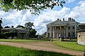 Hale House

| Civil parish in Engeland | |||
|---|---|---|---|
 | |||
| Situering | |||
| Regio | South East England | ||
| Graafschap | Hampshire | ||
| District | New Forest | ||
| Coördinaten | 50° 58' NB, 1° 43' WL | ||
| Algemeen | |||
| Oppervlakte | 7,4615 km² | ||
| Inwoners (2011) |
519 (70 inw./km²) | ||
| Overig | |||
| Postcode(s) | SO42 | ||
| Netnummer(s) | 01590 | ||
| Grid code | SU1947318945 | ||
| Post town | FORDINGBRIDGE | ||
| ONS-code | E04004570 | ||
| Foto's | |||

| |||
| H.-Mariakerk. | |||
| |||
Geplaatst op:
12-8-2010 |
Dit artikel is een beginnetje over landen & volken. U wordt uitgenodigd om op bewerken te klikken om uw kennis aan dit artikel toe te voegen. |