Bestand:Zaire, Shaba region. LOC 82691524.tif

Afmetingen van deze voorvertoning van het type JPG van dit TIF-bestand: 800 × 585 pixels Andere resoluties: 320 × 234 pixels | 640 × 468 pixels | 1.024 × 749 pixels | 1.280 × 936 pixels | 2.560 × 1.872 pixels | 9.957 × 7.280 pixels.
Oorspronkelijk bestand (9.957 × 7.280 pixels, bestandsgrootte: 207,39 MB, MIME-type: image/tiff)
| Dit is een bestand van Wikimedia Commons. Onderstaande beschrijving komt van de beschrijving van het bestand daar. |
Beschrijving
| Beschrijving |
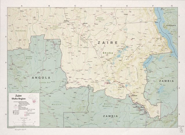
English: Shows roads, railroads, airfields, and major mines. "504765 (543942) 4-81." Relief shown by shading and spot heights. Includes location map. Index on verso. Available also through the Library of Congress Web site as a raster image. |
||
| Title | Zaire, Shaba region. | ||
| Shelf ID | G8653.S5 1981 .U5 | ||
| Datum | |||
| Bron | https://www.loc.gov/item/82691524/ | ||
| Auteur | United States. Central Intelligence Agency | ||
| Toestemming (Hergebruik van dit bestand) |
|
||
| Andere versies |
|
||
| Location | Katanga · Congo · Democratic Republic | ||
| Part of | American Memory · General Maps · Catalog · Geography And Map Division | ||
| Subject | Katanga · Congo (Democratic Republic) · Mines And Mineral Resources · Maps · Congo · Katanga (Congo) |


Licentie
| This image is a work of a Central Intelligence Agency employee, taken or made as part of that person's official duties. As a Work of the United States Government, this image or media is in the public domain in the United States.
|

|
Bestandsgeschiedenis
Klik op een datum/tijd om het bestand te zien zoals het destijds was.
| Datum/tijd | Miniatuur | Afmetingen | Gebruiker | Opmerking | |
|---|---|---|---|---|---|
| huidige versie | 13 jun 2018 00:00 |  | 9.957 × 7.280 (207,39 MB) | Fæ | LOC Maps https://www.loc.gov/item/82691524/ #13361 |
Bestandsgebruik
Dit bestand wordt op de volgende pagina gebruikt: