Bestand:Wilton Crescent.jpg
Geen hogere resolutie beschikbaar.
Wilton_Crescent.jpg (640 × 480 pixels, bestandsgrootte: 91 kB, MIME-type: image/jpeg)
| Dit is een bestand van Wikimedia Commons. Onderstaande beschrijving komt van de beschrijving van het bestand daar. |
Beschrijving
| Beschrijving |
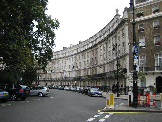
English: Belgravia: Wilton Crescent, SW1 Wilton Crescent, to the north-west of Belgrave Square was laid out in 1827 as part of the new Grosvenor Estate, built on the lands of the Duke of Westminster. The buildings in this part of the crescent were refaced with stone in the early 1900s, making them look different from the stuccoed terraces which are a characteristic feature of the rest of the estate.
The red and white flag is that of the Singaporean High Commission at 9 Wilton Crescent. This view is of the western arc of the crescent. Danny's 213435 shows the eastern arc. |
| Datum | |
| Bron | From geograph.org.uk |
| Auteur | Nigel Cox |
| Naamsvermelding (required by the license) | Nigel Cox / Belgravia: Wilton Crescent, SW1 / |
| Cameralocatie | | Deze en andere afbeeldingen in: OpenStreetMap |
|---|
Licentie

|
Deze afbeelding komt uit de Geograph British Isles-collectie. Zie de pagina van deze foto op de website van Geograph voor contactinformatie van de fotograaf. Het auteursrecht van deze foto is in handen van Nigel Cox en de foto is gelicenceerd voor hergebruik onder de Creative Commons Naamsvermelding-Gelijk delen 2.0 licentie.
|
Dit bestand is gelicenseerd onder de Creative Commons-licentie Naamsvermelding-Gelijk delen 2.0 Unported
Naamsvermelding: Nigel Cox
- De gebruiker mag:
- Delen – het werk kopiëren, verspreiden en doorgeven
- Remixen – afgeleide werken maken
- Onder de volgende voorwaarden:
- naamsvermelding – U moet op een gepaste manier aan naamsvermelding doen, een link naar de licentie geven, en aangeven of er wijzigingen in het werk zijn aangebracht. U mag dit op elke redelijke manier doen, maar niet zodanig dat de indruk wordt gewekt dat de licentiegever instemt met uw werk of uw gebruik van zijn werk.
- Gelijk delen – Als u het werk heeft geremixt, veranderd, of erop heeft voortgebouwd, moet u het gewijzigde materiaal verspreiden onder dezelfde licentie als het oorspronkelijke werk, of een daarmee compatibele licentie.
Bestandsgeschiedenis
Klik op een datum/tijd om het bestand te zien zoals het destijds was.
| Datum/tijd | Miniatuur | Afmetingen | Gebruiker | Opmerking | |
|---|---|---|---|---|---|
| huidige versie | 20 nov 2009 16:09 | | 640 × 480 (91 kB) | Himalayan Explorer | {{Information |Description={{en|1=k}} |Source=k |Author=k |Date=k |Permission= |other_versions= }} |
Bestandsgebruik
Dit bestand wordt op de volgende pagina gebruikt:
Globaal bestandsgebruik
De volgende andere wiki's gebruiken dit bestand:
- Gebruikt op azb.wikipedia.org
- Gebruikt op de.wikipedia.org
- Gebruikt op en.wikipedia.org
- Gebruikt op it.wikipedia.org
- Gebruikt op ja.wikipedia.org
- Gebruikt op no.wikipedia.org
- Gebruikt op vi.wikipedia.org
- Gebruikt op www.wikidata.org
- Gebruikt op zh.wikipedia.org