Bestand:Werther (Westf.) - land utilization.svg

Afmetingen van deze voorvertoning van het type PNG van dit SVG-bestand: 639 × 600 pixels Andere resoluties: 256 × 240 pixels | 512 × 480 pixels | 818 × 768 pixels | 1.091 × 1.024 pixels | 2.183 × 2.048 pixels | 860 × 807 pixels.
Oorspronkelijk bestand (SVG-bestand, nominaal 860 × 807 pixels, bestandsgrootte: 277 kB)
| Dit is een bestand van Wikimedia Commons. Onderstaande beschrijving komt van de beschrijving van het bestand daar. |
_-_land_utilization.svg)
Beschrijving
| Beschrijving |
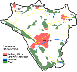
English: Land utilization in Werther (Westf.)
Deutsch: Flächennutzung in Werther (Westf.) |
| Datum | |
| Bron | Eigen werk |
| Auteur | Hagar66 |
| Cameralocatie | | Deze en andere afbeeldingen in: OpenStreetMap |
|---|
_-_land_utilization.svg¶ms=052.076389_N_0008.413611_E_globe:Earth_type:camera__&language=nl)
Homemade maps cannot be 100% accurate. This is especially true for topographical data that is hard to incorporate 100% correctly in such maps. You are free to use the map as a starting point for your new improved versions.
Licentie
| Ik, de auteursrechthebbende van dit werk, geef dit werk vrij in het publieke domein. Dit is wereldwijd van toepassing. In sommige landen is dit wettelijk niet mogelijk; in die gevallen geldt: Ik sta iedereen toe dit werk voor eender welk doel te gebruiken, zonder enige voorwaarden, tenzij zulke voorwaarden door de wet worden voorgeschreven. |
Bestandsgeschiedenis
Klik op een datum/tijd om het bestand te zien zoals het destijds was.
| Datum/tijd | Miniatuur | Afmetingen | Gebruiker | Opmerking | |
|---|---|---|---|---|---|
| huidige versie | 6 jan 2009 17:37 | | 860 × 807 (277 kB) | Hagar66 | {{Information |Description={{en|1=Land utilization in Werther (Westf.)}} {{de|1=Flächennutzung in Werther (Westf.)}} |Source=Eigenes Werk (own work) |Author=Hagar66 |Date=6. January 2008 |
Bestandsgebruik
Dit bestand wordt op de volgende pagina gebruikt:
Globaal bestandsgebruik
De volgende andere wiki's gebruiken dit bestand:
- Gebruikt op azb.wikipedia.org
- Gebruikt op de.wikipedia.org
- Gebruikt op ja.wikipedia.org
_-_land_utilization.svg)