Bestand:Wales Administrative Map 2009.png
Grootte van deze voorvertoning: 380 × 599 pixels. Andere resoluties: 152 × 240 pixels | 304 × 480 pixels | 487 × 768 pixels | 649 × 1.024 pixels | 2.150 × 3.389 pixels.
Oorspronkelijk bestand (2.150 × 3.389 pixels, bestandsgrootte: 1,09 MB, MIME-type: image/png)
| Dit is een bestand van Wikimedia Commons. Onderstaande beschrijving komt van de beschrijving van het bestand daar. |
Beschrijving
| Beschrijving |
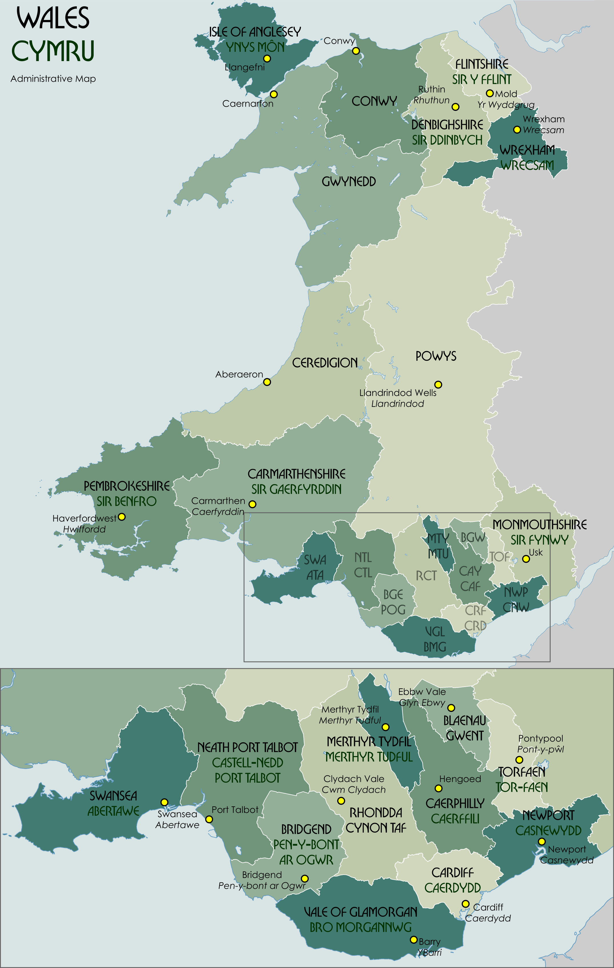
English: Administrative map showing the unitary authorities of Wales and their administrative HQs. |
| Datum | |
| Bron | Eigen werk |
| Auteur | XrysD |
Code for clickable map

Licentie
Ik, de auteursrechthebbende van dit werk, maak het hierbij onder de volgende licentie beschikbaar:

|
Toestemming wordt verleend voor het kopiëren, verspreiden en/of wijzigen van dit document onder de voorwaarden van de GNU-licentie voor vrije documentatie, versie 1.2 of enige latere versie als gepubliceerd door de Free Software Foundation; zonder Invariant Sections, zonder Front-Cover Texts, en zonder Back-Cover Texts. Een kopie van de licentie is opgenomen in de sectie GNU-licentie voor vrije documentatie. |
Bestandsgeschiedenis
Klik op een datum/tijd om het bestand te zien zoals het destijds was.
| Datum/tijd | Miniatuur | Afmetingen | Gebruiker | Opmerking | |
|---|---|---|---|---|---|
| huidige versie | 30 nov 2021 14:33 | | 2.150 × 3.389 (1,09 MB) | XrysD | Correct version |
| 30 nov 2021 14:28 |  | 2.150 × 3.389 (951 kB) | XrysD | Fixed typo (Gaerfyddin->Caerfyrddin for the city) | |
| 25 mei 2016 19:43 |  | 2.150 × 3.389 (1,18 MB) | XrysD | Change Monmouthshire admin HQ from Cwmbran to Usk. | |
| 26 sep 2012 20:22 |  | 2.150 × 3.389 (1,16 MB) | XrysD | Fixed typo (Gaerfyddin->Gaerfyrddin) | |
| 26 sep 2012 13:51 |  | 2.150 × 3.389 (1,14 MB) | Citypeek | removal watermark | |
| 4 sep 2010 00:18 |  | 2.150 × 3.389 (1,17 MB) | XrysD | Fixed order of NTL/CTL ISO 3166-2 code. | |
| 4 sep 2010 00:09 |  | 2.150 × 3.389 (1,17 MB) | XrysD | Fixed Torfaen so that English/Welsh names in correct order. Minor change to title font size. | |
| 3 sep 2010 23:54 |  | 2.150 × 3.389 (1,17 MB) | XrysD | Changed Celtic Hand font to Bullion to improve legibility. Rationalised names so that format is English over Welsh for UA and admin centres. Changed Welsh UA names to green colour adopting system used for railway signs in Wales. | |
| 16 jan 2010 13:18 |  | 2.150 × 3.389 (1,12 MB) | XrysD | Made spelling corrections and colour changes | |
| 16 jan 2010 12:03 |  | 2.150 × 3.389 (1,13 MB) | XrysD | Removed Cardiganshire as alternative name for Ceredigion. Added sig. Moved label for Swansea slightly. |
Bestandsgebruik
Dit bestand wordt op de volgende pagina gebruikt:
Globaal bestandsgebruik
De volgende andere wiki's gebruiken dit bestand:
- Gebruikt op af.wikipedia.org
- Gebruikt op ar.wikipedia.org
- Gebruikt op ast.wikipedia.org
- Gebruikt op bxr.wikipedia.org
- Gebruikt op ca.wikipedia.org
- Gebruikt op cy.wikipedia.org
- Gebruikt op en.wikipedia.org
- Gebruikt op es.wikipedia.org
- Gebruikt op eu.wikipedia.org
- Gebruikt op fa.wikipedia.org
- Gebruikt op fi.wikipedia.org
- Gebruikt op fr.wikipedia.org
- Gebruikt op fr.wiktionary.org
- Gebruikt op ga.wikipedia.org
- Gebruikt op gd.wikipedia.org
- Gebruikt op id.wikipedia.org
- Gebruikt op is.wikipedia.org
- Gebruikt op it.wikipedia.org
- Gebruikt op ja.wikipedia.org
- Gebruikt op kn.wikipedia.org
- Gebruikt op ko.wikipedia.org
- Gebruikt op lld.wikipedia.org
- Gebruikt op mn.wikipedia.org
- Gebruikt op mt.wikipedia.org
- Gebruikt op mzn.wikipedia.org
- Gebruikt op no.wikipedia.org
- Gebruikt op ps.wikipedia.org
- Gebruikt op sco.wikipedia.org
- Gebruikt op simple.wikipedia.org
- Gebruikt op sr.wikipedia.org
- Gebruikt op test2.wikipedia.org
- Gebruikt op tr.wikipedia.org
- Gebruikt op vi.wikipedia.org
- Gebruikt op zh.wikipedia.org
Globaal gebruik van dit bestand bekijken.